 Old Cumbria Gazetteer
 |
 |
|
| Heron Island, Rydal Water | ||
| Heron Island | ||
| site name:- | Rydal Water | |
| civil parish:- | Lakes (formerly Westmorland) | |
| county:- | Cumbria | |
| locality type:- | island | |
| coordinates:- | NY35580623 | |
| 1Km square:- | NY3506 | |
| 10Km square:- | NY30 | |
|
|
||
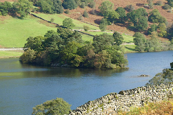 BPS14.jpg The larger island is Heron Island, with a tiny rock beside it at this level of water. (taken 7.10.2008) 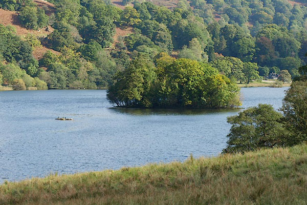 BPS15.jpg There is a smaller island to the SW. (taken 7.10.2008) |
||
|
|
||
| evidence:- | old map:- OS County Series (Wmd 26 1) placename:- Heron Island |
|
| source data:- | Maps, County Series maps of Great Britain, scales 6 and 25
inches to 1 mile, published by the Ordnance Survey, Southampton,
Hampshire, from about 1863 to 1948. |
|
|
|
||
| evidence:- | probably old map:- Saxton 1579 |
|
| source data:- | Map, hand coloured engraving, Westmorlandiae et Cumberlandiae Comitatus ie Westmorland
and Cumberland, scale about 5 miles to 1 inch, by Christopher Saxton, London, engraved
by Augustinus Ryther, 1576, published 1579-1645. Sax9NY30.jpg Lake and island. item:- private collection : 2 Image © see bottom of page |
|
|
|
||
| evidence:- | probably old map:- Jansson 1646 |
|
| source data:- | Map, hand coloured engraving, Cumbria and Westmoria, ie
Cumberland and Westmorland, scale about 3.5 miles to 1 inch, by
John Jansson, Amsterdam, Netherlands, 1646. JAN3NY30.jpg Island; assuming the lake is Rydal Water. item:- JandMN : 88 Image © see bottom of page |
|
|
|
||
| evidence:- | probably old map:- Morden 1695 (Cmd) |
|
| source data:- | Map, uncoloured engraving, Cumberland, scale about 4 miles to 1
inch, by Robert Morden, 1695, published by Abel Swale, the
Unicorn, St Paul's Churchyard, Awnsham, and John Churchill, the
Black Swan, Paternoster Row, London, 1695-1715.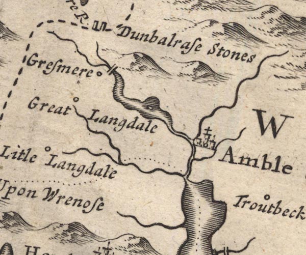 MD12NY30.jpg In Rydal Water. item:- JandMN : 90 Image © see bottom of page |
|
|
|
||
| evidence:- | old map:- Morden 1695 (Wmd) |
|
| source data:- | Map, hand coloured engraving, Westmorland, scale about 2.5 miles to 1 inch, by Robert
Morden, published by Abel Swale, the Unicorn, St Paul's Churchyard, Awnsham, and John
Churchill, the Black Swan, Paternoster Row, London, 1695.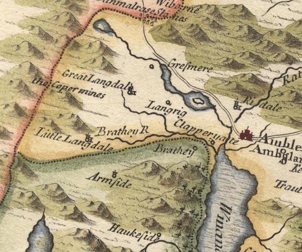 MD10NY30.jpg Island in Rydal Water. item:- JandMN : 24 Image © see bottom of page |
|
|
|
||
| evidence:- | old text:- Clarke 1787 |
|
| source data:- | Guide book, A Survey of the Lakes of Cumberland, Westmorland,
and Lancashire, written and published by James Clarke, Penrith,
Cumberland, and in London etc, 1787; published 1787-93. goto source goto sourcePage 125:- "..." "... the largest island is covered with wood, and has a small house upon it, ..." |
|
|
|
||
| evidence:- | old map:- Clarke 1787 map (Ambleside to Keswick) |
|
| source data:- | Map, A Map of the Roads Lakes etc between Keswick and Ambleside,
scale about 2.5 ins to 1 mile, by James Clarke, engraved by S J
Neele, 352 Strand, published by James Clarke, Penrith,
Cumberland and in London etc, 1787. CL9NY30N.jpg In Rydal Water. item:- private collection : 10.9 Image © see bottom of page |
|
|
|
||
| evidence:- | old text:- Wordsworth 1810 |
|
| source data:- | Guide book, A Description of the Scenery of the Lakes, later A
Guide through the District of The Lakes, by William Wordsworth,
1810-35. goto source page 120 "... and, far advanced as the season was, the trees on the larger Island of Rydal-mere retained a splendour which did not need the heightening of sunshine. We noticed, as we passed, that the line of the grey rocky shore of that island, shaggy with variegated bushes and shrubs, and spotted and striped with purplish brown heath, indistinguishably blending with its image reflected in the still water, produced a curious resemblance, both in form and colour, to a richly-coated caterpillar, as it might appear through a magnifying glass of extraordinary power. ..." |
|
|
|
||
| evidence:- | descriptive text:- Otley 1823 (5th edn 1834) item:- heronry |
|
| source data:- | Guide book, A Concise Description of the English Lakes, the
mountains in their vicinity, and the roads by which they may be
visited, with remarks on the mineralogy and geology of the
district, by Jonathan Otley, published by the author, Keswick,
Cumberland now Cumbria, by J Richardson, London, and by Arthur
Foster, Kirkby Lonsdale, Cumbria, 1823; published 1823-49,
latterly as the Descriptive Guide to the English Lakes. goto source Page 109:- "... Rydal Water, with the heronry upon one of its islands; ..." |
|
|
|
||
| evidence:- | old text:- Martineau 1855 item:- heronry |
|
| source data:- | Guide book, A Complete Guide to the English Lakes, by Harriet
Martineau, published by John Garnett, Windermere, Westmorland,
and by Whittaker and Co, London, 1855; published 1855-76. goto source Page 53:- "... The islands are wooded; and on one of them is a heronry; and the grey bird, with its long flapping wings, is most likely visible, either in flight, or perched on a tree near its nest, or fishing in the shallows. ..." |
|
|
|
||
| evidence:- | perhaps old print:- Robertson 1911 |
|
| source data:- | Print, lithograph? Rydal Water, from a watercolour by Arthur Tucker, published by
Chatto and Windus, London, 1911.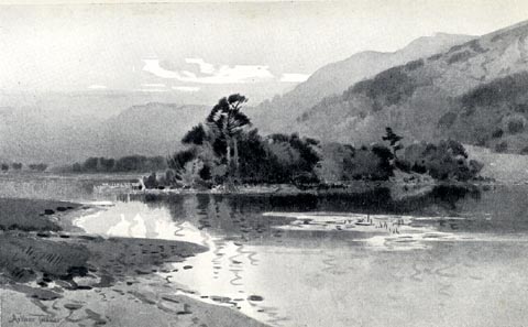 click to enlarge click to enlargeRSN140.jpg Tipped in opposite p.266 of Wordsworthshire by Eric Robertson. Heron Island in the middle ground? printed at bottom:- "RYDAL WATER" signed at painting lower left:- "Arthur Tucker" item:- JandMN : 197.44 Image © see bottom of page |
|
|
|
||
| evidence:- | old print:- Payn 1860s-70s placename:- Heron Island |
|
| source data:- | Print, colour printed, Heron Island, Rydal Water, Westmorland, published by John Garnett,
Windermere, Westmorland, and by Simpkin, Marshall and Co, London, 1860s-70s?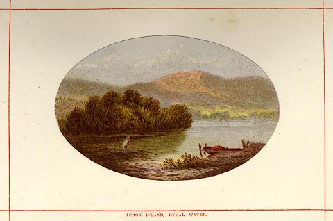 click to enlarge click to enlargePN0106.jpg Tipped in opposite p.24 of England's Lakeland, a Tour Therein, by James Payn. printed at bottom:- "HERON ISLAND, RYDAL WATER." item:- Armitt Library : A1183.6 Image © see bottom of page |
|
|
|
||
| evidence:- | outline view:- Tattersall 1836 (version 1869) |
|
| source data:- | Print, hand coloured, Rydal Water, from the South East, Westmorland, drawn by George
Tattersall, 1836, engraved by W F Topham, published by T J Allman, 463 Oxford Street,
London, 1869.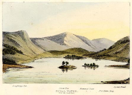 click to enlarge click to enlargeTAT206.jpg Included in The Lakes of England, by W F Topham. printed at bottom:- "RYDAL WATER, / from the South East." printed at bottom:- "Loughrigg Fell. / Silver How. / Hammar Scarr. / Pt. of Helm Crag. / Rydal Head." item:- Armitt Library : A1067.6 Image © see bottom of page |
|
|
|
||
| evidence:- | outline view:- Tattersall 1836 |
|
| source data:- | Print, engraving, Rydal Water, from the South East, Westmorland, drawn by George Tattersall,
engraved by W F Topham, published by Sherwood and Co, Paternoster Row, London, about
1836.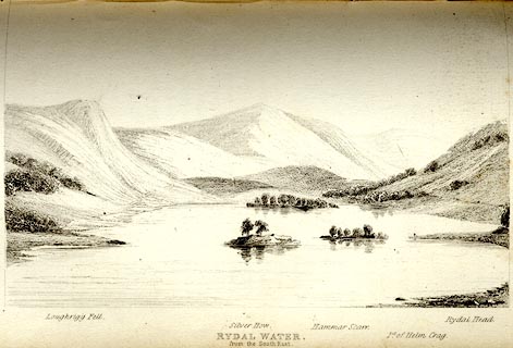 click to enlarge click to enlargeTAT111.jpg The print is captioned with mountain names and acts as an outline view. Tipped in opposite p.44 of The Lakes of England, by George Tattersall. printed at bottom:- "RYDAL WATER, / from the South East." printed at bottom left to right:- "Loughrigg Fell. / Silver How. / Hammar Scarr. / Pt. of Helm Crag. / Rydal Head." item:- Armitt Library : A1204.12 Image © see bottom of page |
|
|
|
||
Lakes Guides menu.