 Old Cumbria Gazetteer
 |
 |
|
| Furness | ||
| High Furness | ||
| Low Furness | ||
| county:- | Cumbria (Lancashire) | |
| locality type:- | locality (ill defined) | |
| 10Km square:- | SD27 (etc) | |
| 1Km square:- | SD2070 | |
| 10Km square:- | SD26 | |
| 10Km square:- | SD27 | |
| 10Km square:- | SD28 | |
| 10Km square:- | SD29 | |
|
|
||
| evidence:- | old map:- Paris 1240s placename:- Furneis |
|
| source data:- | Map, version B, northern England, Scotland and part of Wales, by Matthew Paris, 1240s.
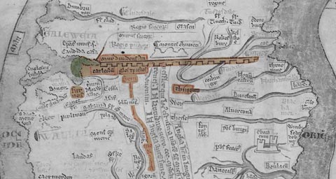 click to enlarge click to enlargePAR2Cm.jpg "fur / neis" derived from copyright image, courtesy of Corpus Christi College item:- Corpus Christi, Cambridge : MS16.f4.5 Image © see bottom of page |
|
|
|
||
| evidence:- | old map:- Lloyd 1573 placename:- Furnes |
|
| source data:- | Map, hand coloured copper plate engraving, Angliae Regni,
Kingdom of England, with Wales, scale about 24 miles to 1 inch, authored by Humphrey
Lloyd, Denbigh, Clwyd, drawn and engraved
by Abraham Ortelius, Netherlands, 1573. click to enlarge click to enlargeLld1Cm.jpg "Furnes" item:- Hampshire Museums : FA1998.69 Image © see bottom of page |
|
|
|
||
| evidence:- | poem:- Drayton 1612/1622 text placename:- Furnesse |
|
| source data:- | Poem, Poly Olbion, by Michael Drayton, published by published by
John Marriott, John Grismand and Thomas Dewe, and others?
London, part 1 1612, part 2 1622. goto source goto sourcepage 135:- "... then Furnesse whose sterne face, With Mountaines set like Warts, which Nature as a grace Bestow'd upon this Tract, whose Browes doe looke so sterne, That when the Nymphs of Sea did first her Front discerne, Amazedly they fled, to Amphitrite's Bower. Her grim aspect to see, which seem'd to them so sower, ..." goto sourcepage 136:- "... That when the Saxons here their forces first did plant, And from the Inner-land the ancient Britains drave, To their distrest estate it no lesse succour gave, Then the trans-Severn'd Hills, which their old stocke yet stores, Which now we call the Welsh, or the Cornubian Shores, What Countrey lets ye see those soyles within her Seat, But shee in little hath, what it can shew in great." |
|
|
|
||
| evidence:- | old map:- West 1784 map placename:- Low Furness |
|
| source data:- | Map, hand coloured engraving, A Map of the Lakes in Cumberland,
Westmorland and Lancashire, scale about 3.5 miles to 1 inch,
engraved by Paas, 53 Holborn, London, about 1784.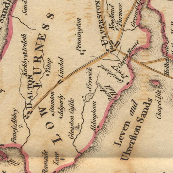 Ws02SD27.jpg "LOW FURNESS" item:- Armitt Library : A1221.1 Image © see bottom of page |
|
|
|
||
| evidence:- | old text:- Camden 1789 placename:- Foreness placename:- Fourness |
|
| source data:- | Book, Britannia, or A Chorographical Description of the Flourishing Kingdoms of England,
Scotland, and Ireland, by William Camden, 1586, translated from the 1607 Latin edition
by Richard Gough, published London, 1789. goto source Page 131:- "..." "While I was looking round from this hill [in Lancaster] for the mouth of the Lone which empties itself not much below, Forness, the other part of this county, almost torn off by the sea, presented itself to my view. For the shore here running out a great way to the west, the sea, as if enraged at it, lashes it more furiously, and, in high tides. has even devoured the shore, and made three large bays, viz. Kentsand, into which the river Ken empties itself, Levensand and Duddensand, between which the land projects in such a manner that it has its name thence, Foreness and Foreland signifying the same with us as Promontorium anterius in Latin." |
|
|
|
||
| evidence:- | old text:- Camden 1789 (Gough Additions) item:- slate; furnace; holly; oak; tree; tanning; charcoal |
|
| source data:- | Book, Britannia, or A Chorographical Description of the Flourishing Kingdoms of England,
Scotland, and Ireland, by William Camden, 1586, translated from the 1607 Latin edition
by Richard Gough, published London, 1789. goto source Page 142:- "..." "Mr. Camden speaks of Furness as almost separated from Lancashire by the encroachment of the sea. He might have affirmed that it is no where else connected with any part of the county. ..." goto sourcePage 142:- "..." "The low or plain part of Furness, which is so called to distinguish it from the woody or mountainous part, produces all sorts of grain, but principally oats, whereof the bread eaten in this country is generally made; and there are found here veins of a very rich iron ore, which is not only melted and wrought here, but great quantities are exported to other parts to mix with poorer ores." "In the mountainous parts of this country are found quarries of a fine durable blue slate to cover buildings with, which are made use of in many other parts of the kingdom; and here are several cotton-mills lately erected; and if fuel for fire were more plentiful, the trade in this country would much increase; but there being no coals nearer than Wigan or Whitehaven, and the coast duties high, firing is rather scarce, the country people using only turf or peat, and that begins to be more scarce than formerly." "Bishop Gibson derives the name of Fourness from the numerous furnaces there antiently, whose rents and services called Bloomsmithy rent are still annually paid." "In the mosses of Furness much fir is found, but more oak: the trunks in general lie with their heads to the east, the high winds having been from the west. High Furness has ever had great quantities of sheep which browse upon the hollies left in great numbers for them; and produces charcoal for melting iron ore, and oak bark for tanners' use in great abundance. Low Furness was applied to the uses of agriculture. The forests abounded with deer and wild boars, and the legh or scofe or large stags, whose horns are frequently found underground here." |
|
|
|
||
| evidence:- | old map:- Close 1805 placename:- Furness |
|
| source data:- | Map, uncoloured engraving, A Map of Furness, Lancashire, scale
about 4 miles to 1 inch, by William Close, engraved by R Hixon,
355 Strand, London, published 1805. "A MAP of FURNESS" 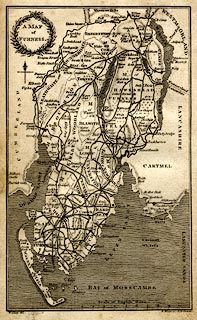 click to enlarge click to enlargeCS02.jpg item:- private collection : 202.1 Image © see bottom of page |
|
|
|
||
| evidence:- | old text:- Capper 1808 placename:- Furness item:- charcoal; coppicing |
|
| source data:- | Gazetteer, A Topographical Dictionary of the United Kingdom,
compiled by Benjamin Pitts Capper, published by Richard
Phillips, Bridge Street, Blackfriars, London, 1808; published
1808-29. goto source "[Hawkshead] ... Hawkshead is the principal town in what is called the district of Furness, or woody fells; the woods are chiefly charred here at the growth of about 15 years, for the uses of the numerous forges and founderies in the neighbourhood. The mountains, although of unpromising appearance, produce plenty of slate and copper ore, and their rugged sides furnish food to great numbers of sheep, whose wool produces both employment and clothing to the poorer inhabitants. ..." |
|
|
|
||
| evidence:- | old text:- Wordsworth 1810 placename:- Low Furness placename:- High Furness item:- sheep; holly trees; ash trees |
|
| source data:- | Guide book, A Description of the Scenery of the Lakes, later A
Guide through the District of The Lakes, by William Wordsworth,
1810-35. goto source page 43 "..." ""While the villains of Low Furness were thus distributed over the land, and employed in agriculture; those of High Furness were charged with the care of flocks and herds, to protect them from the wolves which lurked in the thickets, and in winter to browze them with the tender sprouts of hollies and ash. This custom was not till lately discontinued in High Furness; and holly-trees were carefully preserved for that purpose when all other wood was cleared off; large tracts of common being so covered with these trees, as to have the appearance of a forest of hollies. At the Shepherd's call, the flocks surrounded the holly-bush, and received the croppings at his hand, which they greedily nibbled up, bleating for" |
|
|
|
||
| evidence:- | old text:- Martineau 1855 item:- drawing |
|
| source data:- | Guide book, A Complete Guide to the English Lakes, by Harriet
Martineau, published by John Garnett, Windermere, Westmorland,
and by Whittaker and Co, London, 1855; published 1855-76. goto source Page 22:- "..." "All the way to Furness, ... There are few objects more picturesque, to this day, than the huts of the woodcutters, who remain on a particular spot till their work is done. Upon piled stems of trees heather is heaped, to make a shaggy" goto sourcePage 23:- "thatch; and when the smoke is oozing out, thin and blue, from the hole in the centre, or the children are about the fire in front, where the great pot is boiling, the sketcher cannot but stop and dash down the scene in his book. The children will say he is "spying fancies," - as they say of every one who sketches, botanizes, or in any way explores; and perhaps somebody may have the good taste to advise him to come at night, when the glow from the fires makes the thicket a scene of singular wildness and charm. A sad story about a charcoal-burner belongs to this neighbourhood. On two farms lived families which were about to be connected by marriage. The young lover was a "coaler," - a charcoal-burner; and one stormy day, when he was watching his fire, and sitting on a stone near his hut to take his dinner, he was struck dead by lightning. The poor crazed survivor, his Kitty Dawson, went to that hut after the funeral, and would never leave it again. She did nothing but sit on that stone, or call his name through the wood. She was well cared for. There was always food in the hut, and some kind eye daily on the watch,- though with care not to intrude. One day in winter, some sportsmen who were passing took the opportunity of leaving some provision in the hut. They became silent, and silenced their dogs. But she could never more be disturbed. They found her dead." |
|
|
|
||
| evidence:- | text:- Mason 1907 (edn 1930) |
|
| source data:- | Text book, The Ambleside Geography Books bk.III, The Counties of
England, by Charlotte M Mason, published by Kegan Paul, Trench,
Trubner and Co, Broadway House, 68-74 Carter Lane, and the
Parents' Educational Union Office, 26 Victoria Street, London,
edn 1930. MSN1P031.txt Page 31:- "..." "FURNESS is a bit of Lancashire entirely separated from the rest of the county by the waters of Morecambe Bay. The little Winster stream alone divides it from Westmoreland, and the Duddon from Cumberland; but nowhere does it touch the shire of which it forms a part." "Furness is in every way like the two counties between which it is wedged; it is a bit of mountain country, full of slate mountains of the Cumbrian group. Like Scotland, it consists of highlands and lowlands: Low Furness is the peninsula at the end of the district, which has low shores and low islands lying off the shores; the largest of these is Walney Isle. Slate is quarried in the slate mountains of High Furness, and veins of lead and copper are worked. In Low Furness, where the rocks are not of slate, but of mountain limestone, a great treasure has been found of late years, enormous beds of iron-ore, which yields iron of the very best kind. This valuable "find" has changed much of Low Furness into a Black Country, full of smoke, and noisy with the roar of blast furnaces and the clang of many hammers. ..." |
|
|
|
||
Lakes Guides menu.