 Old Cumbria Gazetteer
 |
 |
|
| English Gate, Carlisle | ||
| gone | ||
| English Gate | ||
| site name:- | City Walls | |
| locality:- | Carlisle | |
| civil parish:- | Carlisle (formerly Cumberland) | |
| county:- | Cumbria | |
| locality type:- | town gate | |
| coordinates:- | NY40185561 (estimate) | |
| 1Km square:- | NY4055 | |
| 10Km square:- | NY45 | |
| SummaryText:- | Built 1542 to take on the function of Bochard Gate which had become part of the new Citadel. | |
| SummaryText:- | English Gate is often plotted on maps at the Bochard Gate location. | |
|
|
||
| evidence:- | old map:- Ogilby 1675 (plate 86) placename:- English Gate |
|
| source data:- | Road strip map, uncoloured engraving, the Road from Tinmouth ...
to Carlisle, scale about 1 inch to 1 mile, by John Ogilby,
London, 1675.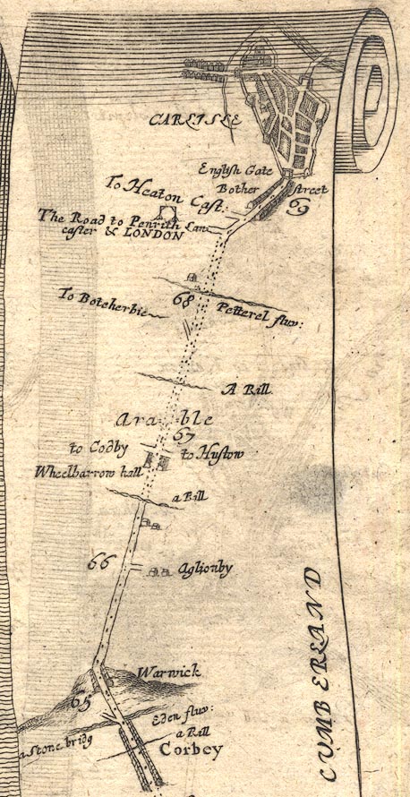 OG86m065.jpg In mile 69, Cumberland. "English Gate" the gate arch drawn over the road. item:- JandMN : 73 Image © see bottom of page |
|
|
|
||
| evidence:- | old map:- Ogilby 1675 (plate 96) placename:- English Gate |
|
| source data:- | Road strip map, hand coloured engraving, the Road from Kendal to
Cockermouth, and the Road from Egremond to Carlisle, scale about
1 inch to 1 mile, by John Ogilby, London, 1675.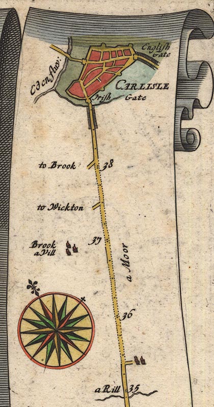 OG96Bm35.jpg In mile 39, Cumberland. "English Gate" through the town walls on the right (south east) of the town. item:- JandMN : 22 Image © see bottom of page |
|
|
|
||
| evidence:- | old map:- Ogilby 1675 (plate 38) placename:- English Gate |
|
| source data:- | Road strip map, hand coloured engraving, continuation of the
Road from London to Carlisle, scale about 1 inch to 1 mile, by
John Ogilby, London, 1675.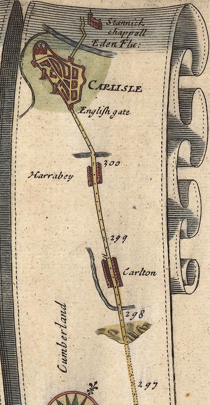 OG38m297.jpg In mile 300, Cumberland. enter Carlisle by:- "English gate" item:- JandMN : 21 Image © see bottom of page |
|
|
|
||
| evidence:- | descriptive text:- Fiennes 1698 |
|
| source data:- | Travel book, manuscript record of Journeys through England
including parts of the Lake District, by Celia Fiennes, 1698. "... you enter [Carlisle] over the bridge and double gates which are iron-grates and lined with a case of doores of thick timber; there are 3 gates to the town one called the English gate at which I entred, ..." |
|
|
|
||
| evidence:- | old text:- Ogilby 1699 (edn 1712) placename:- Bother Gate placename:- English Gate |
|
| source data:- | Road book, itineraries and map, The Traveller's Guide, by John
Ogilby, published by Abel Swall, Tim Child, White Hart, and R
Knaplock, the Angel and Crown, St Paul's Churchyard, London,
1699. OGY7p072.txt page 72 "... Carlile ... having 3 Gates, viz. the Caldo or Irish-Gate, Bother or English-Gate, and Rickard or Scotch-Gate." |
|
|
|
||
| evidence:- | old map:- Bowen 1720 (plate 261) placename:- English Gate |
|
| source data:- | Road strip map, uncoloured engraving, pl.261, the end of the
road from Kendal to Cockermouth and the road from Egremont to
Carlisle, scale about 2 miles to 1 inch, published by Emanuel
Bowen, St Katherines, London, 1720.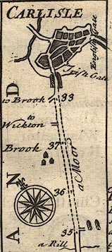 B261m35.jpg The Egremont road shown entering Carlisle by Irish Gate; English Gate to right item:- Dove Cottage : Lowther.36 Image © see bottom of page |
|
|
|
||
| evidence:- | old map:- Bowen 1720 (plate 94) placename:- English Gate |
|
| source data:- | Strip maps, uncoloured engravings, road maps, The Road from
London to Carlisle, scale about 2 miles to 1 inch, with sections
in Lancashire and Westmorland, published by Emanuel Bowen, St
Katherines, London, 1720.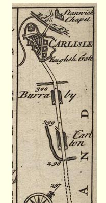 B094m297.jpg Drawn in the town walls, the road entering by English Gate. item:- Dove Cottage : 2007.38.100 Image © see bottom of page |
|
|
|
||
| evidence:- | old map:- Bowen 1720 (plate 161) placename:- English Gate |
|
| source data:- | Road strip map, uncoloured engraving, pl.161, part of The Road
from Carlisle to Barwick, scale about 2 miles to 1 inch, with
sections in Cumberland, and Scotland, published by Emanuel
Bowen, St Katherines, London, 1720. B161m00.jpg "English Gate" item:- JandMN : 65.161 Image © see bottom of page |
|
|
|
||
| evidence:- | old map:- Bowen 1720 (plate 232) placename:- English Gate |
|
| source data:- | Road strip map, road map, pl.232, part of The Road from Tinmouth
to Carlisle, scale about 2 miles to 1 inch, with sections in
Northumberland and Cumberland, published by Emanuel Bowen, St
Katherines, London, 1720.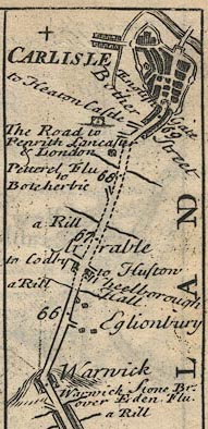 B232m65.jpg "English Gate" Mile 69. item:- JandMN : 65.232 Image © see bottom of page |
|
|
|
||
| evidence:- | old text:- Gents Mag placename:- Bother Gate placename:- English Gate |
|
| source data:- | Magazine, The Gentleman's Magazine or Monthly Intelligencer or
Historical Chronicle, published by Edward Cave under the
pseudonym Sylvanus Urban, and by other publishers, London,
monthly from 1731 to 1922. goto source goto sourceGentleman's Magazine 1745 p.674 "..." "It is at present a wealthy and populous place, the houses are well built, and city walled in, having three gates, viz. the Caldo or Irish gate on the S. West, the Bother or English gate on the South, and the Rickard or Scotch gate towards the North. ..." "..." "This observation is made by the reverend compiler of the Magna Britannia antiqua et nova, from whom the foregoing description is taken, except a correction of him with regard to the situation of the place, all our news papers following this writer (who might have informed himself better from honest Speed) having turned the city about and placed the English gate in the West and the Irish in the South." |
|
|
|
||
| evidence:- | old map:- Donald 1774 (Cmd) placename:- English Gate |
|
| source data:- | Map, hand coloured engraving, 3x2 sheets, The County of Cumberland, scale about 1
inch to 1 mile, by Thomas Donald, engraved and published by Joseph Hodskinson, 29
Arundel Street, Strand, London, 1774.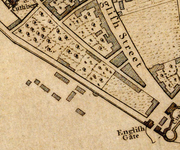 D44055D.jpg "English Gate" town gate item:- Carlisle Library : Map 2 Image © Carlisle Library |
|
|
|
||
| evidence:- | descriptive text:- Baker 1802 placename:- |
|
| source data:- | Perspective road map with sections in Lancashire, Westmorland,
and Cumberland, by J Baker, London 1802. Page 27:- "... [Carlisle] hath three entrances by gates, strongly fortified; that to the west is called the English gate, one to the south is called the Irish gate, and another northward is called the Scotch gate. ..." |
|
|
|
||
| evidence:- | old print:- Thurnam 1835 placename:- English Gate |
|
| source data:- | Print, uncoloured lithograph, The English Gate and Old Gaol, Carlisle, Cumberland,
drawn by M E Nutter, lithographed by Giles, published by Charles Thurnam, Carlisle,
Cumberland, by Ackermann and Co, by Hodgson, Boys, and Graves, and by Charles Tilt,
London, 1835.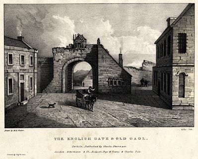 click to enlarge click to enlargeTHM104.jpg Printed by Graf and Soret. Included in Carlisle in the Olden Time. printed at bottom:- "Drawn by M. E. Nutter. / Giles lith. / THE ENGLISH GATE & OLD GAOL. / Published by Charles Thurnam. / London. Ackermann & Co. - Hodgson, Boys, and Graves & Charles Tilt. / Printed by Graf &Soret." item:- Dove Cottage : 2008.123.4 Image © see bottom of page |
|
|
|
||
| evidence:- | old painting:- placename:- English Gate |
|
| source data:- | Painting, watercolour, The English Gate and Gaol, Carlisle, Cumberland, by Robert
Carlyle snr, 1791.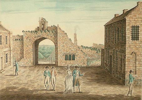 click to enlarge click to enlargePR0908.jpg Courtyard framed on two sides by English Gate to rear and the jail, which stands at right angles to it, to right. In centre foreground stand four figures; a lady and three gentlemen. To far right of composition a man walks past, reading a pamphlet (?) as he walks; a dead rabbit hangs limply from his right hand. To left, an elderly man approaches the doorway of the building which stands opposite the jail. Wooded landscape lies beyond. One of a set of 11 original drawings for proposed aquatints The Antiquities of the City of Carlisle, 1791 inscribed at bottom centre:- "The ENGLISH GATE and GAOL, CARLISLE." item:- Tullie House Museum : 1935.80.3 Image © Tullie House Museum |
|
|
|
||
| evidence:- | old painting:- |
|
| source data:- | Painting, watercolour, The English Gate, Carlisle, Cumberland, by W Hetherington,
about 1880.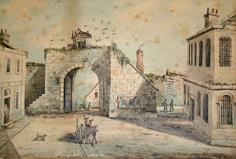 click to enlarge click to enlargePR1357.jpg View of the English Gate in the centre of the composition with Carlisle Gaol to the right and buildings to the left. A chimney produces smoke from a building beyond the Gate. A small building has been erected on top of the English Gate. A man draws a horse and cart in the foreground. Based on original watercolour by Robert Carlyle dated 1791. signed at bottom right:- "W Hetherington" item:- Tullie House Museum : 2004.1.20 Image © Tullie House Museum |
|
|
|
||
| notes:- |
gateway, demolished |
|
| Perriam, D R &Robinson, J: 1998: Medieval Fortified Buildings of Cumbria: CWAAS::
ISBN 1 873124 23 6; plan and illustration |
||
|
|
||
Lakes Guides menu.