 Old Cumbria Gazetteer
 |
 |
|
| Cunningarth, Westward | ||
| Cunningarth | ||
| civil parish:- | Westward (formerly Cumberland) | |
| county:- | Cumbria | |
| locality type:- | buildings | |
| coordinates:- | NY26714643 | |
| 1Km square:- | NY2646 | |
| 10Km square:- | NY24 | |
|
|
||
| evidence:- | old map:- OS County Series (Cmd 29 10) placename:- Cunningarth |
|
| source data:- | Maps, County Series maps of Great Britain, scales 6 and 25
inches to 1 mile, published by the Ordnance Survey, Southampton,
Hampshire, from about 1863 to 1948. |
|
|
|
||
| evidence:- | old text:- Gents Mag placename:- Coning Garth item:- roman finds; roman inscription |
|
| source data:- | Magazine, The Gentleman's Magazine or Monthly Intelligencer or
Historical Chronicle, published by Edward Cave under the
pseudonym Sylvanus Urban, and by other publishers, London,
monthly from 1731 to 1922. goto source goto sourceGentleman's Magazine 1748 p.179 "Mr URBAN," "I SEnd you some pieces of antiquity, which I lately discovered in the wall and adjoining houses of an obscure farm at Coning-garth, about 2 short miles southward from Wigton, in Cumberland, and not far from a large Roman encampment, called Old Carlisle, on the military way leading to Ellenborough." "Old Carlisle has been variously understood by antiquaries; but Mr Horsley's opinion, that it was the Roman Olenacum, seems to have the greatest weight, where the Ala Herculea encamp'd at the time of the Notitia." 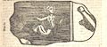 click to enlarge click to enlargeG748E05.jpg "FIG. I. is a Triton; the stone is about 21/2foot by 16 inches; whether there has been any figure on the other sides cannot be learn'd, as 'tis built in the wall; it is in full demi-relievo, and tolerably well executed, at least much better than many sculptures of those times, but 'tis imperfect; below the tail has been another figure, but the stone is broke off; and, facing the Triton a third also defac'd and imperfect." 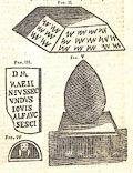 click to enlarge click to enlargeG748E06.jpg "FIG. II. is the corner stone of a stable, or barn, at the very foundation, probably a pedestal to a funeral monument. The figures on it resemble scales, or waves, and whether it has been a plinth for the Triton, and the whole a sepulchral pillar, is not now to be determin'd." "FIG III. is an inscription, now placed horizontally, as the upper lintel of a window near the Triton, by which it seems probable that the Ala Augusta had some time garrison'd this place; it is of the funeral kind, and dedicated to the Dis Manibus. I hope the curious will oblige us with their reading and interpretation of it." "FIG. IV. is a view of a stone, which I take to be the capital of the whole monument; the length of the plinth is 171/2inches, breadth 12, height 7 inches, of which 2 are edg'd away in a slope moulding, and the spheroid on the plinth is 20 inches" |
|
|
|
||
| evidence:- | old text:- Gents Mag 1748 |
|
| source data:- | goto source Gentleman's Magazine 1748 p.180 "high, 14 inches diameter one way, and 12 the other, exactly equal to the breadth of the base, and wrought over with a kind of net-work, probably taken from the cone of a fir-apple. Its most singular curiosity is, that plinth and spheroid make but one entire stone, contrary to the custom of the moderns spiking their globes. I am persuaded if the whole funeral obelisk had been entire, it would have been one of the most curious of the kind yet discovered. At present it lies in a back yard, useless and disregarded." "Yours, &c. G.S." "... ..." |
|
|
|
||
| evidence:- | old map:- Donald 1774 (Cmd) placename:- Cunningarth |
|
| source data:- | Map, hand coloured engraving, 3x2 sheets, The County of Cumberland, scale about 1
inch to 1 mile, by Thomas Donald, engraved and published by Joseph Hodskinson, 29
Arundel Street, Strand, London, 1774.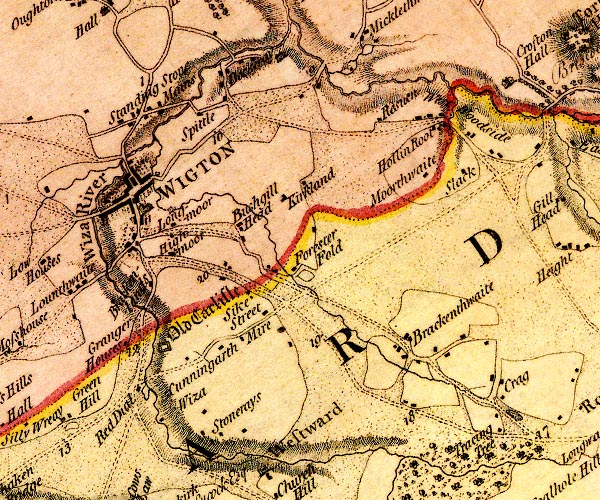 D4NY24NE.jpg "Cunningarth" block or blocks, labelled in lowercase; a hamlet or just a house item:- Carlisle Library : Map 2 Image © Carlisle Library |
|
|
|
||
Lakes Guides menu.