button to main menu  Old Cumbria Gazetteer
Castlesteads, Stainton
Castlesteads
site name:-   Helm, The
civil parish:-   Stainton (formerly Westmorland)
civil parish:-   Kendal (formerly Westmorland)
county:-   Cumbria
locality type:-   earthwork
locality type:-   hillfort (?) 
coordinates:-   SD53088876
1Km square:-   SD5388
10Km square:-   SD58

evidence:-   old map:- OS County Series (Wmd 39 13) 
placename:-  Castle Steads
placename:-  Castrum Exploratorium
source data:-   Maps, County Series maps of Great Britain, scales 6 and 25 inches to 1 mile, published by the Ordnance Survey, Southampton, Hampshire, from about 1863 to 1948.
"Castle Steads (CASTRUM EXPLORATORIUM)"

evidence:-   descriptive text:- West 1778 (11th edn 1821) 
placename:-  Castle Steads
source data:-   Guide book, A Guide to the Lakes, by Thomas West, published by William Pennington, Kendal, Cumbria once Westmorland, and in London, 1778 to 1821.
image WS21P014, button  goto source
Page 14:-  "... the castellum on the summit of a hill that rises immediately above Watercrook, at present called Castle Steads."
"..."
image WS21P184, button  goto source
Page 184:-  "... on the crest of a green hill, on the left, called Helm, are the vestiges of a castellum, called Castle-steads, which, during the residence of the watchmen at Watercrook, corresponded (by smoke in the day, and flame in the night) with the garrison at Lancaster, by the beacon on Warton-crag. There is a house at a distance to the north, called Watch-house, where Roman coins have been found."

evidence:-   probably old text:- Camden 1789 (Gough Additions) 
placename:-  Castle Steeds
source data:-   Book, Britannia, or A Chorographical Description of the Flourishing Kingdoms of England, Scotland, and Ireland, by William Camden, 1586, translated from the 1607 Latin edition by Richard Gough, published London, 1789.
image CAM2P152, button  goto source
Page 152:-  "..."
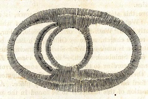
"About a mile and an half from this fort was the castrum exploratorum, now called Castle Steeds, 60 feet by 120, having two ditches on the south end and three on the north; the other sides steep. At the bottom of the hill a large spring."

evidence:-   old print:- 
placename:-  Castlesteads
item:-  roman
source data:-   Print, uncoloured engraving, plan of Castlesteads on The Helm, published by Hudson and Nicholson, Kendal, Westmorland, 1832.
image  click to enlarge
PR0734.jpg
On p.14 of The Annals of Kendal by Cornelius Nicholson. 
item:-  private collection : 125.7
Image © see bottom of page

evidence:-   site plan:- Historical Monuments 1936
placename:-  Castlesteads
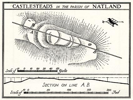
source data:-   Site plan, uncoloured lithograph, Castlesteads in the Parish of Natland, Stainton, Westmorland, scale about 1 to 1100, published by Royal Commission on Historical Monuments England, London, 1936.
image  click to enlarge
HMW109.jpg
On p.181 of the Inventory of the Historical Monuments in Westmorland. 
printed, top  "CASTLESETADS IN THE PARISH OF NATLAND"
RCHME no. Wmd, Natland 8 
item:-  Armitt Library : A745.110
Image © see bottom of page

button to lakes menu  Lakes Guides menu.