Old Cumbria Gazetteer
 |
 |
|
||
| Brackenthwaite, Buttermere | ||||
| Brackenthwaite | ||||
| civil parish:- | Buttermere (formerly Cumberland) | |||
| county:- | Cumbria | |||
| locality type:- | locality | |||
| locality type:- | buildings | |||
| coordinates:- | NY15362219 (etc etc) | |||
| 1Km square:- | NY1522 | |||
| 10Km square:- | NY12 | |||
|
|
||||
| evidence:- | old map:- OS County Series (Cmd 63 10) placename:- Brackenthwaite |
|||
| source data:- | Maps, County Series maps of Great Britain, scales 6 and 25
inches to 1 mile, published by the Ordnance Survey, Southampton,
Hampshire, from about 1863 to 1948. |
|||
|
|
||||
| evidence:- | old map:- Saxton 1579 placename:- Brakenthwate |
|||
| source data:- | Map, hand coloured engraving, Westmorlandiae et Cumberlandiae Comitatus ie Westmorland
and Cumberland, scale about 5 miles to 1 inch, by Christopher Saxton, London, engraved
by Augustinus Ryther, 1576, published 1579-1645.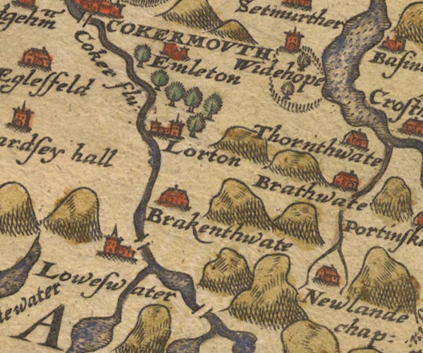 Sax9NY12.jpg Building, symbol for a hamlet, which may or may not have a nucleus. "Brakenthwate" item:- private collection : 2 Image © see bottom of page |
|||
|
|
||||
| evidence:- | old map:- Mercator 1595 (edn?) placename:- Brakenthwate |
|||
| source data:- | Map, hand coloured engraving, Northumbria, Cumberlandia, et
Dunelmensis Episcopatus, ie Northumberland, Cumberland and
Durham etc, scale about 6.5 miles to 1 inch, by Gerard Mercator,
Duisberg, Germany, about 1595. MER8CumE.jpg "Brakenthwate" circle item:- JandMN : 169 Image © see bottom of page |
|||
|
|
||||
| evidence:- | old map:- Speed 1611 (Cmd) placename:- Brakenthwate |
|||
| source data:- | Map, hand coloured engraving, Cumberland and the Ancient Citie
Carlile Described, scale about 4 miles to 1 inch, by John Speed,
1610, published by J Sudbury and George Humble, Popes Head
Alley, London, 1611-12.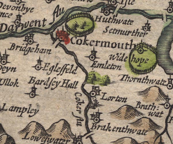 SP11NY12.jpg "Brakenthwate" circle, building, tower item:- private collection : 16 Image © see bottom of page |
|||
|
|
||||
| evidence:- | possibly table of distances:- Simons 1635 placename:- Brakenthwate |
|||
| source data:- | Table of distances, uncoloured engraving, Cumberland, with a
thumbnail map, scale about 41 miles to 1 inch, by Mathew Simons,
published in A Direction for the English Traviller, 1635.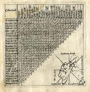 click to enlarge click to enlargeSIM4.jpg "Brake~thwate SW" and tabulated distances; B on thumbnail map item:- private collection : 50.11 Image © see bottom of page |
|||
|
|
||||
| evidence:- | old map:- Jansson 1646 placename:- Brakentwate |
|||
| source data:- | Map, hand coloured engraving, Cumbria and Westmoria, ie
Cumberland and Westmorland, scale about 3.5 miles to 1 inch, by
John Jansson, Amsterdam, Netherlands, 1646.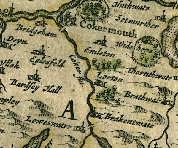 JAN3NY12.jpg "Brakentwate" Buildings and tower. item:- JandMN : 88 Image © see bottom of page |
|||
|
|
||||
| evidence:- | old map:- Morden 1695 (Cmd) placename:- Brakenthwate |
|||
| source data:- | Map, uncoloured engraving, Cumberland, scale about 4 miles to 1
inch, by Robert Morden, 1695, published by Abel Swale, the
Unicorn, St Paul's Churchyard, Awnsham, and John Churchill, the
Black Swan, Paternoster Row, London, 1695-1715.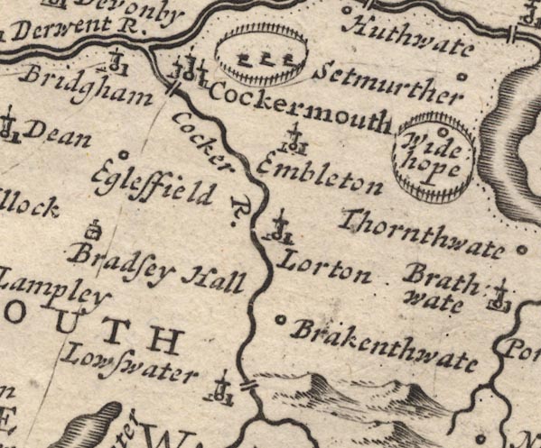 MD12NY12.jpg "Brakenthwate" Circle. item:- JandMN : 90 Image © see bottom of page |
|||
|
|
||||
| evidence:- | old map:- Bowen and Kitchin 1760 placename:- Brackenthwate |
|||
| source data:- | Map, hand coloured engraving, A New Map of the Counties of
Cumberland and Westmoreland Divided into their Respective Wards,
scale about 4 miles to 1 inch, by Emanuel Bowen and Thomas
Kitchin et al, published by T Bowles, Robert Sayer, and John
Bowles, London, 1760. BO18NY12.jpg "Brackenthwate" circle, tower item:- Armitt Library : 2008.14.10 Image © see bottom of page |
|||
|
|
||||
| evidence:- | old text:- Gents Mag item:- rain; storm, 1760; flood, 1760 |
|||
| source data:- | Magazine, The Gentleman's Magazine or Monthly Intelligencer or
Historical Chronicle, published by Edward Cave under the
pseudonym Sylvanus Urban, and by other publishers, London,
monthly from 1731 to 1922. goto source goto sourceGentleman's Magazine 1760 p.520 "An authentic Account of a Water-Spout, which mostly fell upon Brackenthwaite in the County of Cumberland, on Sept. 19, 1760; by an Eye-witness." "THE village of Brackenthwaite, which is part of a large valley extending from N. to S. about five miles in length, and one and a half in breadth, is bounded on the E. by a ridge of very lofty mountains, running from N. to S. the southermost of which, Grassmere, is reputed the highest in England, except Skeddow: its top is quite level, and exceeding spacious, so as almost to equal its base; northward of it there are three others, which rise regularly, and unite in one narrow summit, somewhat lower than Grassmere; with the extremity of which it is connected by a narrow inclined plain. Down the gullies, between these mountains, descend three small brooks, Lizza, Hopebeck, and Habcorton, in streams little more than sufficient to turn an ordinary mill; the first of these enters the plain about the middle; the second at the most northern part of Brackenthwaite; and the third farther northward, at the village of Larton. On the summit, which is common to all the three mountains, and forms as it were their joint top, seems to have been one of the breakings, or falls of water, as all the three brooks were affected by it, nearly all in the same degree. But what made the mischief produced by the others less condsiderable than that by the Lizza, was a second spout on the extremity of the top of Grassmere, the whole of whose waters fell into its channel. This second was the chief cause of the damage which ensued in" |
|||
| source data:- | goto source Gentleman's Magazine 1760 p.521 "the valley, not only by producing a much greater quantity of water than the other, but principally by the vast quantity of rubbish which it brought along with it, the whole side of the mountain, down which it rushed with inconceivable rapidity, being covered with vast heaps of stones, beds of gravel, sand,and earth, which lying loose were easily carried away with so impetuous a torrent. Such a mixture, carried with the velocity which it must necessarily acquire down a slope of a mile in length, and so steep as to make an angle of 60 degrees with the horizon, could not but make terrible havock in the valley. The channel of the brook being rocky, and its bank rising to a considerable height on each side from the place of the water of the second spout's falling into Lizza, and mixing with that of the other down to the plain, it was so far kept within pretty good bounds; but it was no sooner freed from these restraints, than it made the most dreadful devastation. Of the first field it entered, it has swept away both the soil and the gravel quite to the rock; and the second, consisting of ten or twelve acres, is entirely burried under a sand-bank of such a thickness, as never to be removed. Instead of the old channel, which did not exceed five or six feet in breadth, and one in depth, a new one is now made at least 18 or 20 yards in breadth, and one and half deep. Notwithstanding which, it overflowed its bank on each side, in such a prodigious stream, as to be able, at the distance of a quarter of a mile, to wash away a remarkably thick and strong wall; and what is more wonderful, on the other side, even where, on the smooth surface of the meadow, there seemed nothing to resist its progress, in some places, to tear up vast masses of earth, which can no where be found, so as to leave a pit of two yards and half in depth, and of 800 or 1000 yards in area. Several other pits, it is thought, were made, and afterwards filled up again with stones and sand, otherwise it is difficult to imagine how the vast quantities of stone, which composed the walls near the brook, not one of which is remaining, should have disappeared." "Such was the ruin it made in the meadows and arable ground, when at full liberty to spread itself. But it was no sooner, by the inclination of the ground, reduced within more scanty limits, than it began to rage with redoubled fury. Two meadows were entirely taken away, and a bed of sand left in their place, Its course being afterward through a wood, not a tree within its reach was left standing. Two stone bridges, well built and exceedingly strong, were carried away with the torrent, and not one remnant of the materials which composed them to be found: nay, what is more strange, a causeway of prodigious breadth, supported by a most enormous bank of earth, which is remembered these hundred years, has been swept from its foundation, and its place left floated by the stream. In short, nothing which fell in its way was able to resist it; but earth, trees, hedges, stones, walls, bridges, piers and mounds were swept away, till it reached the place where the brook discharges itself into the river Cocker. Here an end was put to its fury; for though the channel of the river was far from being capacious enough to receive the whole of the water, on account of the vast level plain on each side, its overflowings did no damage, as it could only deluge to be stagnant. Happily no houses were within its reach, though one very narrowly escaped, the ground being all carried away to a considerable depth within two yards of it, where the solid rock began, on which the house was founded; and a mill escaped, only by the channel's accidentally diverting its force from it to the opposite bank, which was all torn to pieces." "I endeavoured, but in vain, to get data sufficient on which to build a calculation of the quantity of water which came down; for, as it happened at midnight, neither the time of its continuance could be ascertained, nor could it be determined whether it was constant and regular or variable. A clergyman in the neighbourhood was of opinion, that all the water of Crummack, an adjacent lake of two square miles surface, and very deep, could not have done half so much harm. It is certain, indeed, from one circumstance, that it must have been very great; as the water remained the next morning, in a widow's cottage, twelve feet perpendicular above the ordinary surface of the water, and at the distance of thirty yards from the brook; and as the ground was lower on the opposite bank to the distance of fifty yards, there must have been a stream of at least 4 or 5 yards deep, and 80 or 90 in breadth; and this" |
|||
| source data:- | goto source Gentleman's Magazine 1760 p.522 "where it run with the greatest rapidity at the foot of the mountain." "The effects of the brooks of Hopebeck and Habcorton need not to be so particularly described, being of the same kind with the other, only inferior in degree, both on account of their being swelled by one of the spouts only, &their channels being deeper. However, the damage done by those, tho' inferior to the other, was by no means inconsiderable. One circumstance relative to that of Hopebeck may perhaps deserve to be mentioned: having burst its banks just at the place of crossing the highway, it continued its course along a lane to a considerable distance before it found a passage into the fields; and when the brook subsided, and the supply failed, much water remained stagnant in the hollows of the lane, particularly one before the door of a house, situated on the road. At this the people, not knowing how it could possibly come there, were greatly surprized; but much more, when they found in it a very fine dish of trout." "With regard to the physical cause of this uncommon phaenomenon, there are some circumstances preceding it which seem irrenconcileable with either of the two theories I have seen. The cause assigned in the first theory, viz. various and contrary winds, could not be the real cause, as there was very little wind all the day preceding the event; what there was came constantly from the same quarter, and it entirely ceased in the evening. Neither was there more probability in the other cause's operation, viz. an extraordinary rarefraction of the air by igneous meteors, as there was not the least lightning seen, or thunder heard, nor any other diagnostic of the atmosphere's being charged with a more than ordinary stock of sulphureous exhalations, and nitrous acids at that time." "ROB. DIXON." |
|||
|
|
||||
| evidence:- | old map:- Donald 1774 (Cmd) placename:- Brackenthwaite |
|||
| source data:- | Map, hand coloured engraving, 3x2 sheets, The County of Cumberland, scale about 1
inch to 1 mile, by Thomas Donald, engraved and published by Joseph Hodskinson, 29
Arundel Street, Strand, London, 1774.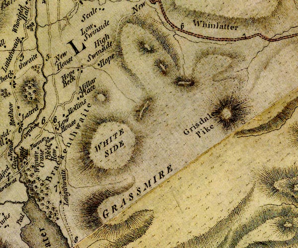 D4NY12SE.jpg "Brackenthwaite" area item:- Carlisle Library : Map 2 Image © Carlisle Library |
|||
|
|
||||
| evidence:- | old map:- Crosthwaite 1783-94 (But/Cru/Low) placename:- Brackenthwaite |
|||
| source data:- | Map, uncoloured engraving, An Accurate Map of Buttermere,
Crummock and Loweswater Lakes, scale about 3 inches to 1 mile,
by Peter Crosthwaite, Keswick, Cumberland, 1794, version
published 1800. CT8NY12K.jpg "Brackenthwaite" item:- Armitt Library : 1959.191.2 Image © see bottom of page |
|||
|
|
||||
| evidence:- | old map:- West 1784 map placename:- Brackenthwaite |
|||
| source data:- | Map, hand coloured engraving, A Map of the Lakes in Cumberland,
Westmorland and Lancashire, scale about 3.5 miles to 1 inch,
engraved by Paas, 53 Holborn, London, about 1784. Ws02NY12.jpg item:- Armitt Library : A1221.1 Image © see bottom of page |
|||
|
|
||||
| evidence:- | old map:- Ford 1839 map placename:- Brackenthwaite |
|||
| source data:- | Map, uncoloured engraving, Map of the Lake District of
Cumberland, Westmoreland and Lancashire, scale about 3.5 miles
to 1 inch, published by Charles Thurnam, Carlisle, and by R
Groombridge, 5 Paternoster Row, London, 3rd edn 1843.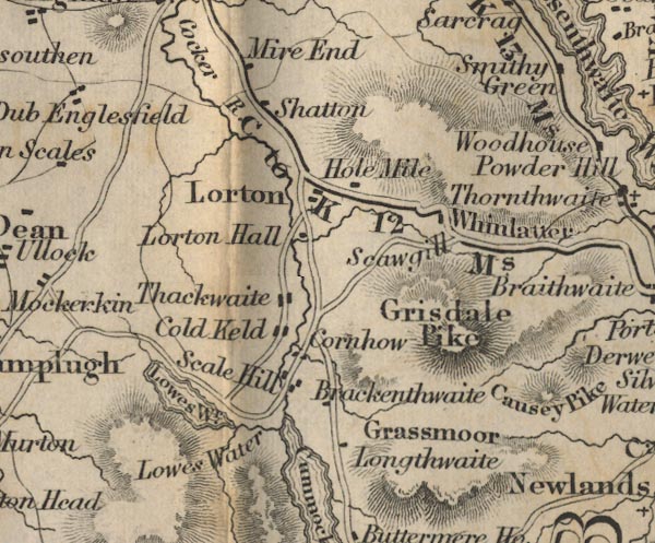 FD02NY12.jpg "Brackenthwaite" item:- JandMN : 100.1 Image © see bottom of page |
|||
|
|
||||
 Martineau Directory 1855 Martineau Directory 1855 |
||||
|
|
||||
| evidence:- | old text:- Martineau 1855 item:- storm, 1760; waterspout; flood, 1760; weather |
|||
| source data:- | Guide book, A Complete Guide to the English Lakes, by Harriet
Martineau, published by John Garnett, Windermere, Westmorland,
and by Whittaker and Co, London, 1855; published 1855-76. goto source Page 131:- "... The most tremendous waterspout remembered in the region of the lakes, descended the ravine between Grassmoor and Whiteside, in 1760. It swept the whole side of Grassmoor at midnight, and carried down everything that was lying loose all through the vale below, and" goto sourcePage 132:- "... The village of Brackenthwaite, which stood directly in its course, was saved by being built on a stone platform,- a circumstance unknown to the inhabitants till they now saw themselves left safe on a promontory, while the soft soil was swept away from beside their very doors, leaving a chasm where the flood had been turned aside by the resistance of their rock. ..." |
|||
|
|
||||
| places:- |
|
|||
|
||||
|
||||
|
||||
|
||||
|
||||
|
||||
|
||||
|
||||
|
||||
|
||||
|
||||
|
||||
|
||||
|
||||
|
||||
|
||||
|
||||
|
||||
|
||||
|
||||
|
||||
|
||||
|
||||
|
||||
|
||||
|
||||
|
||||
|
||||
|
||||
Lakes Guides menu.