 Old Cumbria Gazetteer
 |
 |
|
||
| Bolton-le-Sands, Lancashire | ||||
| Bolton-le-Sands | ||||
| county:- | Lancashire | |||
| locality type:- | locality | |||
| locality type:- | buildings | |||
| coordinates:- | SD48386774 (etc) | |||
| 1Km square:- | SD4867 | |||
| 10Km square:- | SD46 | |||
|
|
||||
| evidence:- | old map:- Ogilby 1675 (plate 38) placename:- Boulton |
|||
| source data:- | Road strip map, hand coloured engraving, continuation of the
Road from London to Carlisle, scale about 1 inch to 1 mile, by
John Ogilby, London, 1675.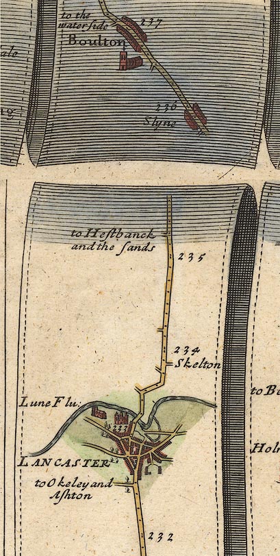 OG38m232.jpg In mile 236, Lancashire. "Boulton" row of houses each side of the road. item:- JandMN : 21 Image © see bottom of page |
|||
|
|
||||
| evidence:- | descriptive text:- West 1778 (11th edn 1821) placename:- Bolton |
|||
| source data:- | Guide book, A Guide to the Lakes, by Thomas West, published by
William Pennington, Kendal, Cumbria once Westmorland, and in
London, 1778 to 1821. goto source goto sourceAddendum; Mr Gray's Journal, 1769 Page 215:- "..." "Oct. 10. I proceeded by Burton to Lancaster, ... Four miles north of Lancaster, on a rising ground, called Bolton (pronounced Bouton) we had a full view of Cartmel sands, with here and there a passenger riding over them (it being low water) the points of Furness shooting far into the sea, and lofty mountains, partly covered with clouds," goto sourcePage 216:- "extending north of them. Lancaster also appeared very conspicuous and fine; for its most distinguished features, the castle and church, mounted on a green eminence, were all that could be seen." |
|||
|
|
||||
| evidence:- | old map:- West 1784 map placename:- Bolton |
|||
| source data:- | Map, hand coloured engraving, A Map of the Lakes in Cumberland,
Westmorland and Lancashire, scale about 3.5 miles to 1 inch,
engraved by Paas, 53 Holborn, London, about 1784.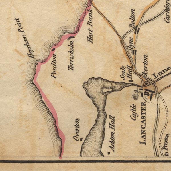 Ws02SD45.jpg item:- Armitt Library : A1221.1 Image © see bottom of page |
|||
|
|
||||
| evidence:- | road book:- Cary 1798 (2nd edn 1802) placename:- Bolton |
|||
| source data:- | Road book, itineraries, Cary's New Itinerary, by John Cary, 181
Strand, London, 2nd edn 1802. goto source click to enlarge click to enlargeC38267.jpg page 267-268 "Bolton - Bull" item:- JandMN : 228.1 Image © see bottom of page |
|||
|
|
||||
| evidence:- | old map:- Baker 1802 placename:- Bolton |
|||
| source data:- | Perspective road maps with sections in Lancashire, Westmorland
and Cumberland, by J Baker, London 1802. Bk03Vg24.jpg "Bolton" item:- private collection : 3 Image © see bottom of page |
|||
|
|
||||
| evidence:- | old map:- Otley 1818 placename:- Bolton |
|||
| source data:- | Map, uncoloured engraving, The District of the Lakes,
Cumberland, Westmorland, and Lancashire, scale about 4 miles to
1 inch, by Jonathan Otley, 1818, engraved by J and G Menzies,
Edinburgh, Scotland, published by Jonathan Otley, Keswick,
Cumberland, et al, 1833.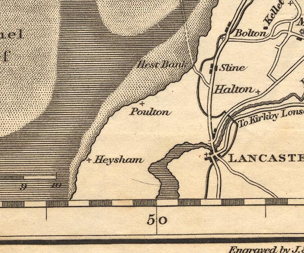 OT02SD46.jpg item:- JandMN : 48.1 Image © see bottom of page |
|||
|
|
||||
| evidence:- | descriptive text:- Ford 1839 (3rd edn 1843) placename:- Bolton-le-Sands |
|||
| source data:- | Guide book, A Description of Scenery in the Lake District, by
Rev William Ford, published by Charles Thurnam, Carlisle, by W
Edwards, 12 Ave Maria Lane, Charles Tilt, Fleet Street, William
Smith, 113 Fleet Street, London, by Currie and Bowman,
Newcastle, by Bancks and Co, Manchester, by Oliver and Boyd,
Edinburgh, and by Sinclair, Dumfries, 1839. goto source Page 152:- "..." "Bolton-le-Sands.- In the neighbourhood of this village, the mountains of Westmorland and Cumberland combine very beautifully with Morecambe Bay." |
|||
|
|
||||
| evidence:- | old map:- Ford 1839 map placename:- Bolton by the Sands |
|||
| source data:- | Map, uncoloured engraving, Map of the Lake District of
Cumberland, Westmoreland and Lancashire, scale about 3.5 miles
to 1 inch, published by Charles Thurnam, Carlisle, and by R
Groombridge, 5 Paternoster Row, London, 3rd edn 1843.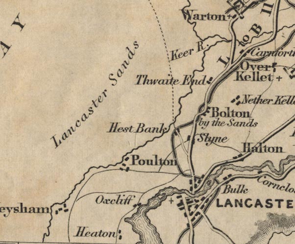 FD02SD46.jpg "Bolton by the Sands" item:- JandMN : 100.1 Image © see bottom of page |
|||
|
|
||||
| evidence:- | old map:- Garnett 1850s-60s H placename:- Bolton |
|||
| source data:- | Map of the English Lakes, in Cumberland, Westmorland and
Lancashire, scale about 3.5 miles to 1 inch, published by John
Garnett, Windermere, Westmorland, 1850s-60s.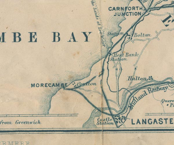 GAR2SD46.jpg "Bolton" blocks, settlement item:- JandMN : 82.1 Image © see bottom of page |
|||
|
|
||||
| evidence:- | old map:- Burrow 1920s |
|||
| source data:- | Road book, On the Road, Dunlop Pictorial Road Plans, volume V,
strip maps with parts in Westmorland, Cumberland etc, irregular
scale about 1.5 miles to 1 inch, by E J Burrow and Co,
Cheltenham, Gloucestershire, 1920s. EJB3Vg02.jpg item:- private collection : 17 Image © see bottom of page |
|||
|
|
||||
| places:- |
|
|||
Lakes Guides menu.