 Old Cumbria Gazetteer
 |
 |
|
||||||||||||
| road, Penrith to Barnard Castle | ||||||||||||||
| Penrith to Barnard Castle | ||||||||||||||
| Barnard Castle to Penrith | ||||||||||||||
| locality:- | Penrith | |||||||||||||
| civil parish:- | Penrith (formerly Cumberland) | |||||||||||||
| county:- | Cumbria | |||||||||||||
| locality type:- | route | |||||||||||||
| locality:- | Barnard Castle | |||||||||||||
| county:- | Durham | |||||||||||||
| locality type:- | route | |||||||||||||
|
|
||||||||||||||
| route parts:- |  Penrith to Appleby Appleby to Brough Brough to Bowes Penrith to Appleby Appleby to Brough Brough to Bowes |
|||||||||||||
|
|
||||||||||||||
| evidence:- | old road book:- Morgan 1759 |
|||||||||||||
| source data:- | MG01p061.txt page 61
item:- private collection : 368 Image © see bottom of page |
|||||||||||||
|
|
||||||||||||||
| evidence:- | old strip map:- Smith 1826 (Roads/Cum) |
|||||||||||||
| source data:- | Strip map, pp.97-99, including To Edinburgh by Carlisle and Longtown, published by
Charles Smith and Son, 172 Strand, London, 1st edn 1826.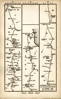 click to enlarge click to enlargeSM22M5.jpg From Bowes, Durham westward; and other routes. Included in Smith's Pocket New Companion to the Roads of England and Wales. printed at p.90:- "TO EDINBURGH / by Carlisle and / LONGTOWN" item:- private collection : 269.5 Image © see bottom of page |
|||||||||||||
|
|
||||||||||||||
| evidence:- | old strip map:- Smith 1826 (Roads/Cum) |
|||||||||||||
| source data:- | Strip map, pp.100-102, including To Edinburgh by Carlisle and Longtown, published
by Charles Smith and Son, 172 Strand, London, 1st edn 1826.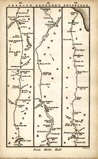 click to enlarge click to enlargeSM22M6.jpg From Rey Cross; through Brough and Appleby, Westmorland; then Penrith, Carlisle, Longtown, Cumberland; into Scotland; and other routes. Included in Smith's Pocket New Companion to the Roads of England and Wales. printed at p.90:- "TO EDINBURGH / by Carlisle and / LONGTOWN" item:- private collection : 269.6 Image © see bottom of page |
|||||||||||||
|
|
||||||||||||||
| evidence:- | old itinerary:- Tinsley 1877 (Roads/Cum) |
|||||||||||||
| source data:- | Itinerary, route 3, London to Edinburgh and Glasgow via Boroughbridge and Carlisle,
including from Bowes, Durham; through Brough, Appleby, Westmorland; then Penrith,
Carlisle, Longtown, Cumberland; and into Scotland, published by Tinsley Bros, 8 Catherine
Street, Strand, London, 1877.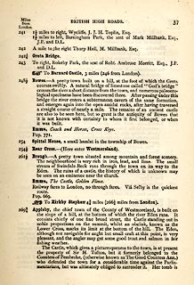 click to enlarge click to enlargeTLY137.jpg pp.36-49 in British High Roads, North and North Eastern Routes; pp.37-39. printed at p.36:- "... / ROUTE III. - LONDON to EDINBURGH and GLASGOW via / BOROUGHBRIDGE and CARLISLE (See Maps 31 to 42.) / Boroughbridge 206 (as per Route I.), Leeming 221½, Catterick 228, Greta Bridge 242½, Bowes 248½, Brough 261½, Appleby 269¾, / Penrith 283½, Carlisle 301½, Longtown 310¼, Langholm 321¾, / Hawick 349½, Selkirk 356, Middleton 379½, Edinburgh 392½. / ..."  click to enlarge click to enlargeTLY138.jpg item:- private collection : 270.1 Image © see bottom of page |
|||||||||||||
|
|
||||||||||||||
| evidence:- | old strip map:- Tinsley 1877 (Roads/Cum) |
|||||||||||||
| source data:- | Strip map, road map, part of London to Edinburgh via Boroughbridge and Carlisle, including
from Rey Cross to beyond Brough, Westmorland, published by Tinsley Bros, 8 Catherine
Street, Strand, London, 1877.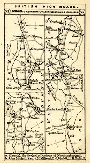 click to enlarge click to enlargeTLY1M1.jpg Map pp.33-34 in British High Roads, North and North Eastern Routes. printed at top:- "BRITISH HIGH ROADS. / 33 LONDON TO EDINBURGH, VIA BOROUGHBRIDGE &CARLISLE. 34" item:- private collection : 270.3 Image © see bottom of page |
|||||||||||||
|
|
||||||||||||||
| evidence:- | old strip map:- Tinsley 1877 (Roads/Cum) |
|||||||||||||
| source data:- | Strip map, road map, part of London to Edinburgh via Boroughbridge and Carlisle, including
from Appleby, Westmorland through Penrith to Carlisle, Cumberland, published by Tinsley
Bros, 8 Catherine Street, Strand, London, 1877.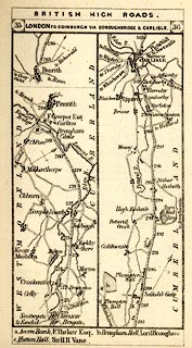 click to enlarge click to enlargeTLY1M2.jpg Map pp.35-36 in British High Roads, North and North Eastern Routes. printed at top:- "BRITISH HIGH ROADS. / 35 LONDON TO EDINBURGH, VIA BOROUGHBRIDGE &CARLISLE. 36" item:- private collection : 270.4 Image © see bottom of page |
|||||||||||||
|
|
||||||||||||||
| evidence:- | old itinerary:- Johnson 1908 (Roads/Cum) |
|||||||||||||
| source data:- | Itinerary, Route 41. in Roads Made Easy by Picture and Pen, Doncaster to Glasgow,
through Appleby, by Claude Johnson, edited by Lord Montagu, published by The Car Illustrated,
168 Piccadilly, London, 1908.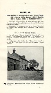 click to enlarge click to enlargeJS5081.jpg pp.81-82 in the road book, Roads Made Easy by Picture and Pen, vol.3. printed at beginning, p.81:- "ROUTE 41. / DONCASTER via Boroughbridge (43½), Scotch Corner (72½), Bowes (88½), Appleby (109¾), Penrith (122¼), Carlisle (140¼) to GLASGOW (235¼)." 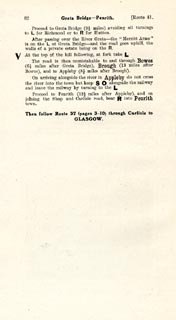 click to enlarge click to enlargeJS5082.jpg item:- private collection : 268.10 Image © see bottom of page |
|||||||||||||
|
|
||||||||||||||
| evidence:- | old itinerary:- Johnson 1908 (Roads/Cum) |
|||||||||||||
| source data:- | Itinerary, Route 41. reverse in Roads Made Easy by Picture and Pen, Glasgow to Doncaster,
through Appleby, by Claude Johnson, edited by Lord Montagu, published by The Car Illustrated,
168 Piccadilly, London, 1908.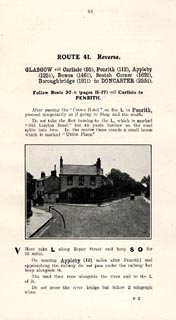 click to enlarge click to enlargeJS5083.jpg pp.83-84 in the road book, Roads Made Easy by Picture and Pen, vol.3. printed at beginning, p.83:- "ROUTE 41. Reverse. / GLASGOW via Carlisle (95), Penrith (113), Appleby (125½), Bowes (146¾), Scotch Corner (162¾), Boroughbrisge (191¾), to DONCASTER (235¼)." 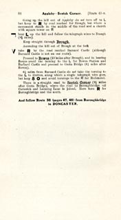 click to enlarge click to enlargeJS5084.jpg item:- private collection : 268.11 Image © see bottom of page |
|||||||||||||
|
|
||||||||||||||
| evidence:- | old strip map:- Geographia 1925 |
|||||||||||||
| source data:- | Road book, with road strip maps and gradient diagrams, Premier Road Book of Great
Britain, by Alexander Gross and F Waite-Browne, published by Geographia, 55 Fleet
Street, London, about 1925?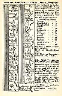 click to enlarge click to enlargeGE1100.jpg "245. - PENRITH, APPLEBY, BARNARD CASTLE." item:- Hampshire Museums : B1990.161.4 Image © see bottom of page |
|||||||||||||
|
|
||||||||||||||
 Lakes Guides menu.