 Old Cumbria Gazetteer
 |
 |
|
| Buckhill Colliery, Broughton | ||
| Buckhill Colliery | ||
| locality:- | Great Broughton | |
| civil parish:- | Broughton (formerly Cumberland) (?) | |
| county:- | Cumbria | |
| locality type:- | coal mine | |
| locality type:- | mine | |
| coordinates:- | NY05863205 (about) | |
| 1Km square:- | NY0532 | |
| 10Km square:- | NY03 | |
|
|
||
| evidence:- | mine plan:- Postlethwaite 1877 placename:- Buckhill Shaft |
|
| source data:- | Print, drawing, geological section, Buckhill Shaft to Low Close, by RWC, 1902, published
by W H Moss and Sons, 13 Lowther Street, Whitehaven, Cumberland, 1877 edn 1913.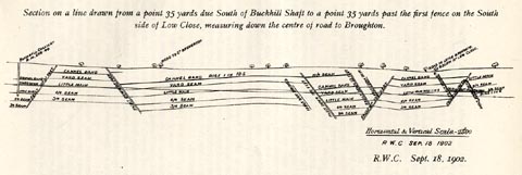 click to enlarge click to enlargePST341.jpg On p.149 of Mines and Mining in the English Lake District, by John Postlethwaite. printed, top "Section on a line drawn from a point 35 yards due South of Buckhill Shaft to a point 35 yards past the first fence on the South / side of Low Close, measuring down the centre of road to Broughton." printed, lower right "Horizontal &Vertical Scale - 1/2500 / R.W.C SEP. 18 1902" item:- JandMN : 162.43 Image © see bottom of page |
|
|
|
||
| evidence:- | Geological Survey, One Inch (sheet 22) placename:- Buckhill Pit |
|
| source data:- | Geological map series, Westmorland and Cumberland, etc, The
Lakes in Cumbria, published by the Ordnance Survey and/or
Geological Survey, 1830s-1900s. "Buckhill Pit" |
|
|
|
||
 Lakes Guides menu.