 Old Cumbria Gazetteer
 |
 |
|
| included in:- |
 Toms Howe, Longsleddale Toms Howe, Longsleddale |
|
| Toms Howe, Longsleddale: Corn Rent Act 1836 | ||
| evidence:- | tithe schedule:- Kendal Corn Rent Act 1836 placename:- Thoms How |
|
| source data:- | Tithe map, Plan of part of the Township of Longsleddale, Westmorland, made regarding
the Kendal Corn Rent Act, ie a tithe award map, scale about 20 inches to 1 mile, Kendal,
Westmorland, 1836. Schedule, each row gives:- Field no. / Tenant's name / Close ie Field name / Type of culture / Area, acres Owned by John Mattinson, tenanted by himself; Thoms How. "/ / Mattinson John" "/ 345 / Himself 11/28 or 11 Gaits on / Cockley Fell / pas/ 104 095" "/ 346 / Do / Grassing / Pas / 42 480" "/ 347 / Do / Intake / Ar &Mea / 8 525" "/ 348 / Do / Corn Hill / Pas / 9 100" "/ 349 / Do / Wither How / Mea / 4 185" "/ 350 / Do / Sand Bed / Mea / 4 340" "/ 351 / Do / Broad Field / Mea / 5 185" "/ 352 / Do / Pieces of Waste / Mea / 0 120" "/ 353 / Do / Fleets / Mea / 2 835" "/ 354 / Do / Fleet Island / Mea / 0 025" "/ 355 / Do / Island / Mea / 0 210" "/ 356 / Do / Crook Close / Mea / 2 075" "/ 357 / Do / Homstd &c at Thoms How / / 0 535" "/ 358 / Do / Good Acre / Mea / 1 875" "/ 359 / Do / Barn &Folds / / 0 040" "/ 360 / Do / Green / Pas / 3 560" "/ 361 / Do / Do / Ar / 3 040" "/ / / / / [total] 192 225" "" 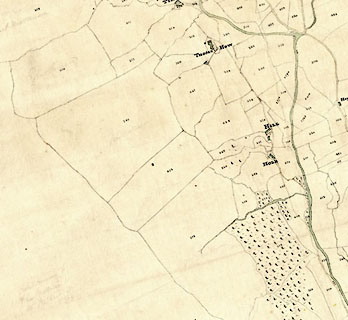 click to enlarge click to enlargeCRny4804.jpg map courtesy of Mark Cropper item:- private collection : 370 Image © see bottom of page |
|
|
|
||
| evidence:- | tithe awards:- Kendal Corn Rent Act 1836 placename:- Thoms How |
|
| source data:- | Plan of the Township of Longsleddale, made for the Kendal Corn Rent Act, ie a tithe
award map, scale about 10 inches to 1 mile, Kendal, Westmorland, 1836. "Mattinson John / Himself / Thoms How / 192 225 192 + 36 / 192 225 192 + 36" |
|
|
|
||
Lakes Guides menu.