 Old Cumbria Gazetteer
 |
 |
|
| lighthouse, Port of Silloth | ||
| gone | ||
| locality:- | Port of Silloth | |
| locality:- | Silloth | |
| civil parish:- | Silloth-on-Solway (formerly Cumberland) | |
| county:- | Cumbria | |
| locality type:- | lighthouse | |
| coordinates:- | NY10355358 (about) | |
| 1Km square:- | NY1053 | |
| 10Km square:- | NY15 | |
|
|
||
| evidence:- | old map:- OS County Series (Cmd 20 11) |
|
| source data:- | Maps, County Series maps of Great Britain, scales 6 and 25
inches to 1 mile, published by the Ordnance Survey, Southampton,
Hampshire, from about 1863 to 1948. "Lighthouse" |
|
|
|
||
| evidence:- | old print:- Cumberland Motor Services 1926 placename:- Silloth Pier placename:- Orifial item:- orifial |
|
| source data:- | Print, halftone photograph, Silloth Pier and Orifial, Silloth-on-Solway, by Photochrom
Co, published by Cumberland Motor Services, Tangier Street, Whitehaven, Cumberland,
about 1926.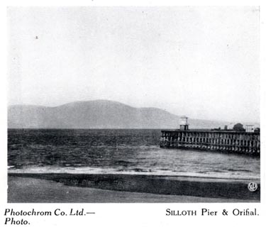 click to enlarge click to enlargeCS109.jpg On p.31 of Cumberland its Lakes and Mountains. lower right "WP" printed, bottom, left right "Photochrom Co. Ltd. Photo. / SILLOTH Pier &Orifial." item:- JandMN : 1022.9 Image © see bottom of page |
|
|
|
||
 Lakes Guides menu.