 Old Cumbria Gazetteer
 |
 |
|
| Walthwaite Bottom, Lakes | ||
| Walthwaite Bottom | ||
| locality:- | Elterwater (near) | |
| civil parish:- | Lakes (formerly Westmorland) | |
| county:- | Cumbria | |
| locality type:- | locality | |
| coordinates:- | NY33100506 (etc) | |
| 1Km square:- | NY3305 | |
| 10Km square:- | NY30 | |
|
|
||
| evidence:- | old map:- OS County Series (Wmd 25 8) placename:- Walthwaite Wood |
|
| source data:- | Maps, County Series maps of Great Britain, scales 6 and 25
inches to 1 mile, published by the Ordnance Survey, Southampton,
Hampshire, from about 1863 to 1948. |
|
|
|
||
| evidence:- | old map:- placename:- Walthwaite Wood |
|
| source data:- | Map, manuscript plan. Walthwaite Wood now Walthwaite Bottom near
Elterwater, Westmorland, by Jonathan Otley, June 1848.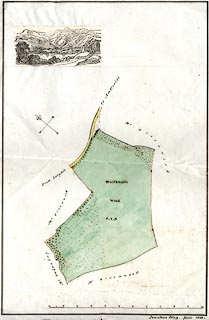 click to enlarge click to enlargeOT14.jpg Map, manuscript plan. Walthwaite Wood now Walthwaite Bottom near Elterwater, Westmorland, by Jonathan Otley, June 1848. ms at bottom right:- "Jonathan Otley, June 1848." item:- private collection : 307 Image © see bottom of page |
|
|
|
||
 Lakes Guides menu.