 Old Cumbria Gazetteer
 |
 |
|
| settlement, Shap Rural | ||
| civil parish:- | Shap Rural (formerly Westmorland) | |
| county:- | Cumbria | |
| locality type:- | british settlement | |
| locality type:- | settlement | |
| coordinates:- | NY507157 (guess) | |
| 1Km square:- | NY5015 | |
| 10Km square:- | NY51 | |
|
|
||
| evidence:- | site plan:- Historical Monuments 1936 |
|
| source data:- | Site plan, uncoloured lithograph, Settlement in Shap Rural, Westmorland, scale about
1 to 1300, published by Royal Commission on Historical Monuments England, London,
1936.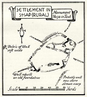 click to enlarge click to enlargeHMW125.jpg On p.211 of the Inventory of the Historical Monuments in Westmorland. printed, upper left "SETTLEMENT IN / SHAP (RURAL) / Monument / No.73 in Text" RCHME no. Wmd, Shap Rural 73; this says it is 600 yards E of Hawes Water, 400 yards SW of Naddle Bridge. item:- Armitt Library : A745.126 Image © see bottom of page |
|
|
|
||
 Lakes Guides menu.