 Old Cumbria Gazetteer
 |
 |
|
| settlement, Hartsop | ||
| locality:- | High Hartsop Dodd | |
| locality:- | Hartsop | |
| civil parish:- | Patterdale (formerly Westmorland) | |
| county:- | Cumbria | |
| locality type:- | british settlement | |
| locality type:- | settlement | |
| coordinates:- | NY39781167 | |
| 1Km square:- | NY3911 | |
| 10Km square:- | NY31 | |
|
|
||
| evidence:- | site plan:- Historical Monuments 1936 |
|
| source data:- | Site plan, uncoloured lithograph, Settlement at Foot of High Hartsop Dod, Hartsop,
Patterdale, Westmorland, scale about 1 to 1300, published by Royal Commission on Historical
Monuments England, London, 1936.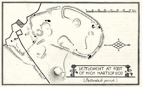 click to enlarge click to enlargeHMW116.jpg On p.194 of the Inventory of the Historical Monuments in Westmorland. printed, lower right "SETTLEMENT AT FOOT / OF HIGH HARTSOP DOD / Patterdale parish" RCHME no. Wmd, Patterdale 61 item:- Armitt Library : A745.117 Image © see bottom of page |
|
|
|
||
 Lakes Guides menu.