 Old Cumbria Gazetteer
 |
 |
|
| Monkhill Mill, Monkhill | ||
| gone | ||
| Monkhill Mill | ||
| site name:- | Greathill Beck | |
| locality:- | Monkhill | |
| locality:- | Hadrian's Wall | |
| civil parish:- | Beaumont (formerly Cumberland) | |
| county:- | Cumbria | |
| locality type:- | windmill | |
| locality type:- | mill | |
| locality type:- | corn mill | |
| coordinates:- | NY34025869 | |
| 1Km square:- | NY3458 | |
| 10Km square:- | NY35 | |
|
|
||
| evidence:- | old map:- OS County Series (Cmd 16) placename:- |
|
| source data:- | Maps, County Series maps of Great Britain, scales 6 and 25
inches to 1 mile, published by the Ordnance Survey, Southampton,
Hampshire, from about 1863 to 1948. "Monkhill Mill" |
|
|
|
||
| evidence:- | old map:- Donald 1774 (Cmd) |
|
| source data:- | Map, hand coloured engraving, 3x2 sheets, The County of Cumberland, scale about 1
inch to 1 mile, by Thomas Donald, engraved and published by Joseph Hodskinson, 29
Arundel Street, Strand, London, 1774.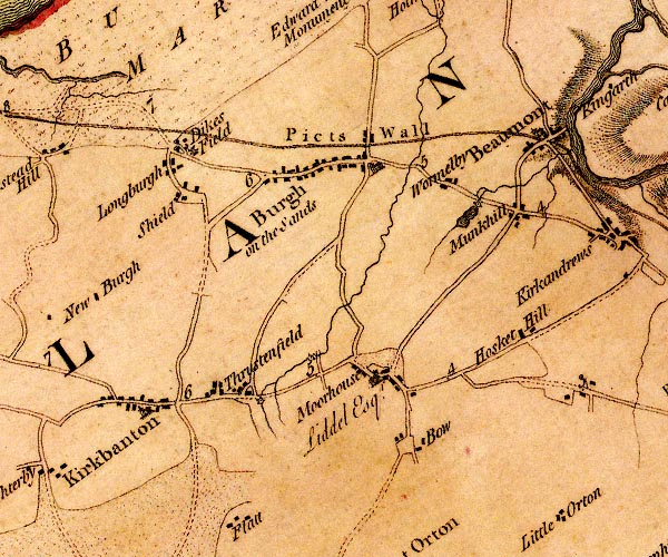 D4NY35NW.jpg circle with rays, mill wheel; a water mill at Munkhill item:- Carlisle Library : Map 2 Image © Carlisle Library |
|
|
|
||
| evidence:- | old text:- Gents Mag item:- riot |
|
| source data:- | Magazine, The Gentleman's Magazine or Monthly Intelligencer or
Historical Chronicle, published by Edward Cave under the
pseudonym Sylvanus Urban, and by other publishers, London,
monthly from 1731 to 1922. goto source goto sourceGentleman's Magazine 1812 part 1 p.480 "The Carlisle Journal states, that tumult and disorder at present prevail in that neighbourhood, and to a greater extent than at any time since the disturbances first broke out. It then proceeds to enumerate a variety of outrages since the 15th, on which day the corn-mill at Monk-hill, near that city, was broken into, and plundered by a number of persons. ..." |
|
|
|
||
Lakes Guides menu.