 Old Cumbria Gazetteer
 |
 |
|
| mill, Bassenthwaite | ||
| site name:- | Halls Beck | |
| locality:- | Bassenthwaite | |
| civil parish:- | Bassenthwaite (formerly Cumberland) | |
| county:- | Cumbria | |
| locality type:- | mill | |
| locality type:- | water mill | |
| coordinates:- | NY23093232 (?) | |
| 1Km square:- | NY2332 | |
| 10Km square:- | NY23 | |
| references:- | Green 1790s-1820s |
|
|
|
||
| evidence:- | old map:- OS County Series (Cmd 47 13) |
|
| source data:- | Maps, County Series maps of Great Britain, scales 6 and 25
inches to 1 mile, published by the Ordnance Survey, Southampton,
Hampshire, from about 1863 to 1948. "Corn Mill / Mill Race / Weir" |
|
|
|
||
| evidence:- | old print:- Green 1790s-1820s |
|
| source data:- | Print, coloured aquatint, Mill near Bassenthwaite, Cumberland, by William Green, Ambleside,
Westmorland, 1790s-1800s?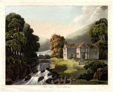 click to enlarge click to enlargePR1729.jpg printed at bottom:- "Mill near Bassenthwaite" item:- Armitt Library : 2014.412 Image © see bottom of page |
|
|
|
||
 Lakes Guides menu.