 |
 |
|
|
|
| runs into:- |
 Lowca Beck Lowca Beck |
|
|
|
|
| civil parish:- |
Distington (formerly Cumberland) |
| civil parish:- |
Lowca (formerly Cumberland) |
| county:- |
Cumbria |
| locality type:- |
river |
| locality type:- |
boundary |
| locality type:- |
parish boundary |
| 1Km square:- |
NX9922 (etc) |
| 10Km square:- |
NX92 |
|
|
| evidence:- |
old map:- OS County Series (Cmd 61 4)
placename:- Distington Beck
|
| source data:- |
Maps, County Series maps of Great Britain, scales 6 and 25
inches to 1 mile, published by the Ordnance Survey, Southampton,
Hampshire, from about 1863 to 1948.
OS County Series (Cmd 61 7)
OS County Series (Cmd 61 8)
|
|
|
| evidence:- |
old map:- Donald 1774 (Cmd)
|
| source data:- |
Map, hand coloured engraving, 3x2 sheets, The County of Cumberland, scale about 1
inch to 1 mile, by Thomas Donald, engraved and published by Joseph Hodskinson, 29
Arundel Street, Strand, London, 1774.
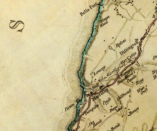
D4NX92SE.jpg
single or double wiggly line; a river
item:- Carlisle Library : Map 2
Image © Carlisle Library |
|
|
| places:- |
|
NX99512193 Barngill Bridge (Distington / Lowca) |
|
|
|
NY00512279 Boot Bridge (Distington) |
|
|
 |
NY00142252 Castle Mill (Distington) |
|
|
|
NY00182247 Castle Mill (Distington) |
|
|
|
NY00952391 Distington Mill (Distington) |
|
|
|
NY00932375 Leads Bridge (Distington) |
|
|
|
NX99512219 mill, Barngill (Lowca) gone |
|
|
|
NY00662294 saw mill, Distington (Distington) gone |
|
