 Old Cumbria Gazetteer
 |
 |
|
| Chapels, Muncaster | ||
| Chapels | ||
| civil parish:- | Muncaster (formerly Cumberland) | |
| county:- | Cumbria | |
| locality type:- | buildings | |
| coordinates:- | SD11079753 | |
| 1Km square:- | SD1197 | |
| 10Km square:- | SD19 | |
|
|
||
| evidence:- | old map:- OS County Series (Cmd 82 8) placename:- Chapel |
|
| source data:- | Maps, County Series maps of Great Britain, scales 6 and 25
inches to 1 mile, published by the Ordnance Survey, Southampton,
Hampshire, from about 1863 to 1948. "Chapel" |
|
|
|
||
| evidence:- | old map:- Donald 1774 (Cmd) |
|
| source data:- | Map, hand coloured engraving, 3x2 sheets, The County of Cumberland, scale about 1
inch to 1 mile, by Thomas Donald, engraved and published by Joseph Hodskinson, 29
Arundel Street, Strand, London, 1774.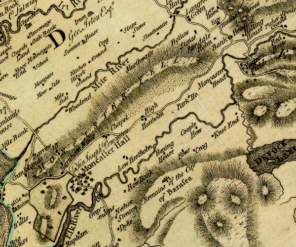 D4SD19NW.jpg "Chapel" block or blocks, labelled in lowercase; a hamlet or just a house item:- Carlisle Library : Map 2 Image © Carlisle Library |
|
|
|
||
| evidence:- | old text:- Gents Mag |
|
| source data:- | Magazine, The Gentleman's Magazine or Monthly Intelligencer or
Historical Chronicle, published by Edward Cave under the
pseudonym Sylvanus Urban, and by other publishers, London,
monthly from 1731 to 1922. goto source goto sourceGentleman's Magazine 1907 part 1 p.171 "About half a mile from the Castle, high on the fellside, is perched a curious old tower known as "Chapels." This building has a room at the bottom and an upper story, which can only be reached by a ladder from outside. It is said that King Henry VI., when he fled from his enemies in 1461, was refused asylum at Irton Hall, and was found by a shepherd wandering on the fell at the spot where Chapels now stands. ..." |
|
|
|
||
| evidence:- | old text:- Gents Mag 1907 |
|
| source data:- | goto source Gentleman's Magazine 1907 part 1 p.173 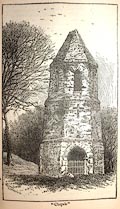 click to enlarge click to enlargeG907E02.jpg Chapels. |
|
|
|
||
Lakes Guides menu.