 Old Cumbria Gazetteer
 |
 |
|
|
| Westmorland: threapland 11 | |||
| Disputed Ground | |||
| civil parish:- | Mallerstang (formerly Westmorland) | ||
| county:- | Cumbria | ||
| locality type:- | threapland | ||
| locality type:- | county boundary | ||
| coordinates:- | SD800979 (etc) | ||
| 1Km square:- | SD8097 | ||
| 10Km square:- | SD89 | ||
| locality:- | Abbotside Common | ||
| county:- | North Yorkshire | ||
|
|
|||
| evidence:- | old map:- Greenwood 1824 |
||
| source data:- | Map, hand coloured engraving, Map of the County of Westmorland,
scale about 1 inch to 1 mile, by C and J Greenwood, published by
George Pringle jnr, 70 Queen Street, Cheapside, London, 1824.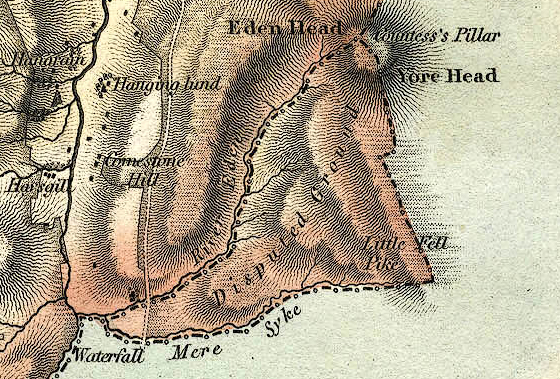 GRW5Th11.jpg "Disputed Ground" item:- Armitt Library : A1827 Image © see bottom of page |
||
|
|
|||
| evidence:- | old map:- Greenwood 1834 |
||
| source data:- | Map, hand coloured engraving, Map of the County of Westmorland,
scale about 3 miles to 1 inch, by C and J Greenwood, 1822-23,
engraved by J and C Walker, 1830, published by Greenwood and Co,
13 Regent Street, Pall Mall, London, 1830-34.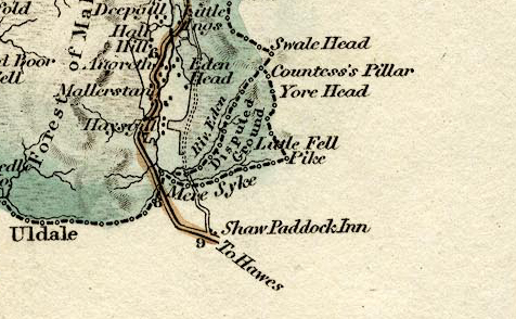 GRW7Th11.jpg "Disputed Ground" item:- Dove Cottage : 2007.38.25 Image © see bottom of page |
||
|
|
|||
| evidence:- | old map:- Bartholomew 1940s |
||
| source data:- | Map, colour lithograph, Bartholomew's Revised Half Inch
Contoured Maps, sheet 35, Teesdale, scale about 2 miles to 1
inch, by John Bartholomew and Sons, The Edinburgh Geographical
Institute, Duncan Street, Edinburgh, Lothian, Scotland, 1952.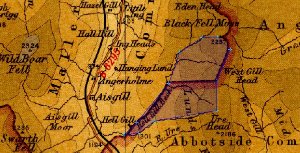 BA22Th11.jpg item:- JandMN : 828.35 Image © see bottom of page |
||
|
|
|||
| mapping:- |  Lady's Pillar, Mallerstang Scarth of Scaiths, Mallerstang Jingling Hole, North Yorkshire Hell Gill Bridge, Mallerstang Lady's Pillar, Mallerstang Lady's Pillar, Mallerstang Scarth of Scaiths, Mallerstang Jingling Hole, North Yorkshire Hell Gill Bridge, Mallerstang Lady's Pillar, Mallerstang |
||
|
|
|||
| mapping:- | Scarth of Scaiths, Mallerstang Hell Gill Bridge, Mallerstang |
||
|
|
|||
Lakes Guides menu.