 Old Cumbria Gazetteer
 |
 |
|
| Stonegarthside, Nicholforest | ||
| Stonegarthside | ||
| civil parish:- | Nicholforest (formerly Cumberland) | |
| county:- | Cumbria | |
| locality type:- | locality | |
| coordinates:- | NY47348032 (etc etc) | |
| 1Km square:- | NY4780 | |
| 10Km square:- | NY48 | |
|
|
||
| evidence:- | old map:- OS County Series (Cmd 3 6) placename:- Stonegarthside |
|
| source data:- | Maps, County Series maps of Great Britain, scales 6 and 25
inches to 1 mile, published by the Ordnance Survey, Southampton,
Hampshire, from about 1863 to 1948. |
|
|
|
||
| evidence:- | perhaps old map:- Burghley 1590 (facsimile) placename:- Staingarthsyde |
|
| source data:- | Facsimile map, A Platt of the Opposete Border of Scotland to ye West Marches of England,
parts of Cumberland and Scotland including the Debateable Land, from a manuscript
drawn for William Cecil, Lord Burghley, about 1590, published by R B Armstrong, 1897. courtesy of the National Library of Scotland 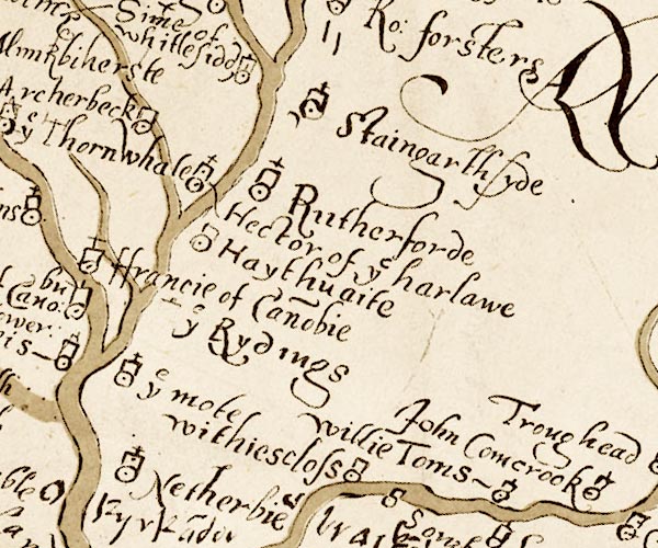 M048NY47.jpg "Staingarthsyde" circle, tower, cross item:- National Library of Scotland : MS6113 f.267 Image © National Library of Scotland |
|
|
|
||
| evidence:- | old map:- Mercator 1595 (edn?) placename:- Stangartikside |
|
| source data:- | Map, hand coloured engraving, Northumbria, Cumberlandia, et
Dunelmensis Episcopatus, ie Northumberland, Cumberland and
Durham etc, scale about 6.5 miles to 1 inch, by Gerard Mercator,
Duisberg, Germany, about 1595. MER8CumA.jpg "Stangartikside" circle item:- JandMN : 169 Image © see bottom of page |
|
|
|
||
| evidence:- | old map:- Millward and Dickinson 1737 placename:- Stangartickside |
|
| source data:- | Road map, photocopy, diagram, A New and Correct Map of Roads of
England, probably published by T Millward and B Dickinson, Inigo
Jones's Head, Fleet Street, London, 1737. "Stangartickside" 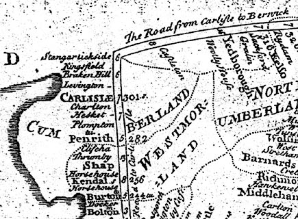 click to enlarge click to enlargeMWD1Cm.jpg item:- private collection : 264 Image © see bottom of page |
|
|
|
||
| evidence:- | old text:- Gents Mag placename:- Stangarth Side item:- rebellion, 1745; 1745 Rebellion |
|
| source data:- | Magazine, The Gentleman's Magazine or Monthly Intelligencer or
Historical Chronicle, published by Edward Cave under the
pseudonym Sylvanus Urban, and by other publishers, London,
monthly from 1731 to 1922. goto source goto sourceGentleman's Magazine 1746 p.233 "... [1745 Rebellion]" "On Thursday [7.11.1745] the eastermost column had gained Stangarth side on the English border, and we suspected their intention was to penetrate thro' the wastes of Beu-castle for Brampton, ..." |
|
|
|
||
| evidence:- | probably old map:- Donald 1774 (Cmd) placename:- Nether Stonegarthside placename:- Stonegarthside, Nether |
|
| source data:- | Map, hand coloured engraving, 3x2 sheets, The County of Cumberland, scale about 1
inch to 1 mile, by Thomas Donald, engraved and published by Joseph Hodskinson, 29
Arundel Street, Strand, London, 1774.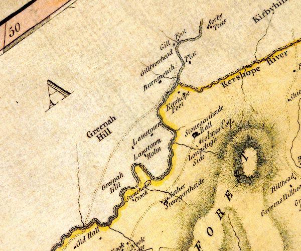 D4NY48SE.jpg "Nether Stonegarthside" block or blocks, labelled in lowercase; a hamlet or just a house item:- Carlisle Library : Map 2 Image © Carlisle Library |
|
|
|
||
Lakes Guides menu.