 Old Cumbria Gazetteer
 |
 |
|
|||||||||||||||||||||
| road, Hawkshead to Whitehaven | |||||||||||||||||||||||
| suggested | |||||||||||||||||||||||
| Hawkshead to Whitehaven | |||||||||||||||||||||||
| Whitehaven to Hawkshead | |||||||||||||||||||||||
| civil parish:- | Hawkshead (formerly Lancashire) | ||||||||||||||||||||||
| civil parish:- | Coniston (formerly Lancashire) | ||||||||||||||||||||||
| civil parish:- | Dunnerdale-with-Seathwaite (formerly Lancashire) | ||||||||||||||||||||||
| civil parish:- | Ulpha (formerly Cumberland) | ||||||||||||||||||||||
| civil parish:- | Eskdale (formerly Cumberland) | ||||||||||||||||||||||
| civil parish:- | Nether Wasdale (formerly Cumberland) | ||||||||||||||||||||||
| civil parish:- | Ennerdale and Kinniside (formerly Cumberland) | ||||||||||||||||||||||
| civil parish:- | Arlecdon and Frizington (formerly Cumberland) | ||||||||||||||||||||||
| civil parish:- | Weddicar (formerly Cumberland) | ||||||||||||||||||||||
| civil parish:- | Whitehaven (formerly Cumberland) | ||||||||||||||||||||||
| county:- | Cumbria | ||||||||||||||||||||||
| locality type:- | route | ||||||||||||||||||||||
| 10Km square:- | SD39 | ||||||||||||||||||||||
| 10Km square:- | NY30 | ||||||||||||||||||||||
| 10Km square:- | NY20 | ||||||||||||||||||||||
| 10Km square:- | NY21 | ||||||||||||||||||||||
| 10Km square:- | NY11 | ||||||||||||||||||||||
| 10Km square:- | NX91 | ||||||||||||||||||||||
| SummaryText:- | this seems a bit unlikely | ||||||||||||||||||||||
| references:- | Bowen and Kitchin 1760 |
||||||||||||||||||||||
|
|
|||||||||||||||||||||||
| evidence:- | old road book:- Morgan 1759 |
||||||||||||||||||||||
| source data:- | MG01p072.txt Burton to Whitehaven page 72
Image © see bottom of page |
||||||||||||||||||||||
|
|
|||||||||||||||||||||||
| evidence:- | old map:- Bowen and Kitchin 1760 |
||||||||||||||||||||||
| source data:- | Map, hand coloured engraving, A New Map of the Counties of
Cumberland and Westmoreland Divided into their Respective Wards,
scale about 4 miles to 1 inch, by Emanuel Bowen and Thomas
Kitchin et al, published by T Bowles, Robert Sayer, and John
Bowles, London, 1760.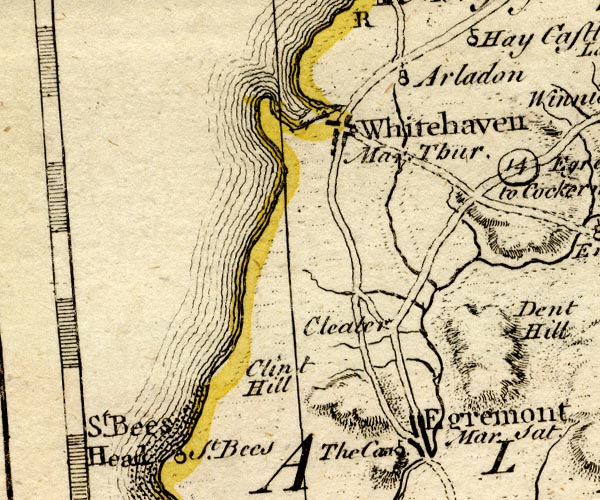 BO18NX91.jpg double line, dotted 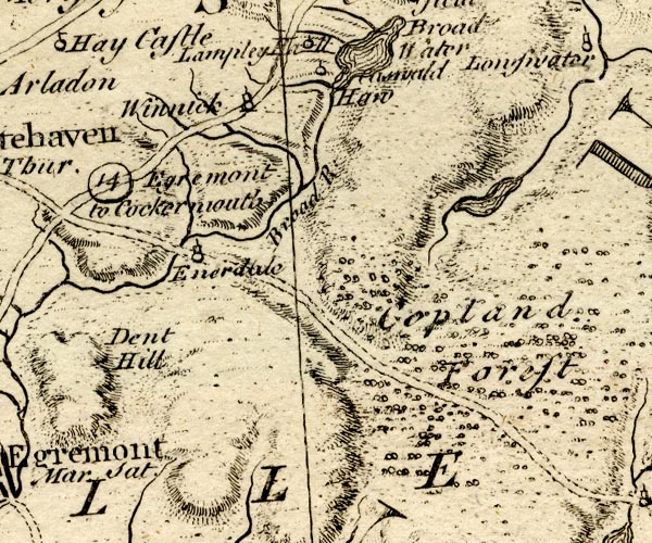 BO18NY01.jpg double line, dotted 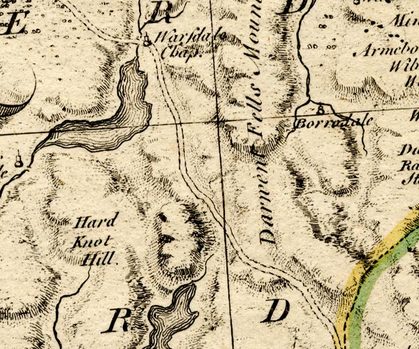 BO18NY10.jpg double line, dotted 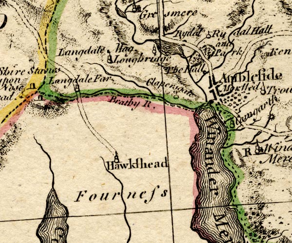 BO18SD29.jpg double line, solid item:- Armitt Library : 2008.14.10 Image © see bottom of page |
||||||||||||||||||||||
|
|
|||||||||||||||||||||||
| evidence:- | old map:- Laurie and Whittle 1806 |
||||||||||||||||||||||
| source data:- | Road map, Completion of the Roads to the Lakes, scale about 10
miles to 1 inch, by Nathaniel Coltman? 1806, published by Robert
H Laurie, 53 Fleet Street, London, 1834. click to enlarge click to enlargeLw18.jpg bold line; 'Principal Travelling Roads', to Wasdale Head item:- private collection : 18.18 Image © see bottom of page |
||||||||||||||||||||||
|
|
|||||||||||||||||||||||
| place:- |  Hawkshead Wasdale Head, Nether Wasdale Ennerdale Bridge, Ennerdale and Kinniside Whitehaven Hawkshead Wasdale Head, Nether Wasdale Ennerdale Bridge, Ennerdale and Kinniside Whitehaven |
||||||||||||||||||||||
|
|
|||||||||||||||||||||||
Lakes Guides menu.