 Old Cumbria Gazetteer
 |
 |
|
| market cross, Kendal | ||
| Cauld Stone | ||
| Ca' Steean | ||
| Street:- | Highgate | |
| locality:- | Kendal | |
| civil parish:- | Kendal (formerly Westmorland) | |
| county:- | Cumbria | |
| locality type:- | market cross | |
| coordinates:- | SD51499263 | |
| 1Km square:- | SD5192 | |
| 10Km square:- | SD59 | |
|
|
||
| MN photo:- |
The Cauld Stone, outside the town hall, was the base of the market cross, where public
announcements used to be made. The cross was removed 1759; the stone kept, and eventually
moved here. |
|
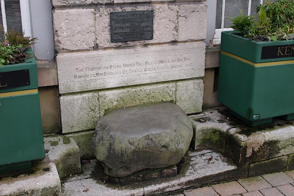 BRZ11.jpg (taken 19.1.2010) 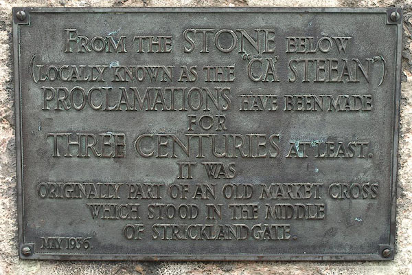 BRZ12.jpg Plaque:- "FROM THE STONE BELOW / (LOCALLY KNOWN AS THE 'CA' STEEAN') / PROCALMATIONS HAVE BEEN MADE / FOR / THREE CENTURIES AT LEAST. / IT WAS / ORIGINALLY PART OF AN OLD MARKET CROSS / WHICH STOOD IN THE MIDDLE / OF STRICKLANDGATE. / MAY 1936." (taken 19.1.2010) |
||
|
|
||
| evidence:- | old map:- OS County Series (Wmd 38 8) placename:- Call Stone, The |
|
| source data:- | Maps, County Series maps of Great Britain, scales 6 and 25
inches to 1 mile, published by the Ordnance Survey, Southampton,
Hampshire, from about 1863 to 1948. "" shown opposite the old town hall |
|
|
|
||
 Lakes Guides menu.