 Old Cumbria Gazetteer
 |
 |
|
|
| Kendal: Milnthorpe Road | |||
| Milnthorpe Road | |||
| locality:- | Kendal | ||
| civil parish:- | Kendal (formerly Westmorland) | ||
| county:- | Cumbria | ||
| locality type:- | street | ||
| coordinates:- | SD513912 (etc) | ||
| 1Km square:- | SD5191 | ||
| 10Km square:- | SD59 | ||
|
|
|||
| evidence:- | old map:- Speed 1611 placename:- Hersoms Lane |
||
| source data:- | Map, hand coloured engraving, The Countie Westmorland and
Kendale the Cheif Towne, scale about 2.5 miles to 1 inch, by
John Speed, 1610, published by George Humble, Popes Head Alley,
London, 1611-12.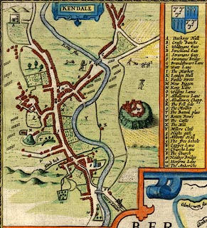 click to enlarge click to enlargeSP14Mk.jpg "10 Hersoms Lane" road S from town, houses item:- Armitt Library : 2008.14.5 Image © see bottom of page |
||
|
|
|||
| mapping:- |  Kendal: Kirkland Nether Bridge, Kendal Kendal: Kirkland Nether Bridge, Kendal Kendal: Kirkland Nether Bridge, Kendal Kendal: Kirkland Nether Bridge, Kendal |
||
|
|
|||
Lakes Guides menu.