 Old Cumbria Gazetteer
 |
 |
|
| boundary stone, Berrier/Murrah (3) | ||
| locality:- | Low Mill | |
| civil parish:- | Mungrisdale (formerly Cumberland) | |
| county:- | Cumbria | |
| locality type:- | boundary stone | |
| locality type:- | township boundary mark | |
| coordinates:- | NY36643254 | |
| 1Km square:- | NY3632 | |
| 10Km square:- | NY33 | |
| locality:- | Berrier and Murrah | |
| locality type:- | township | |
| references:- | Listed Buildings 2010 |
|
|
|
||
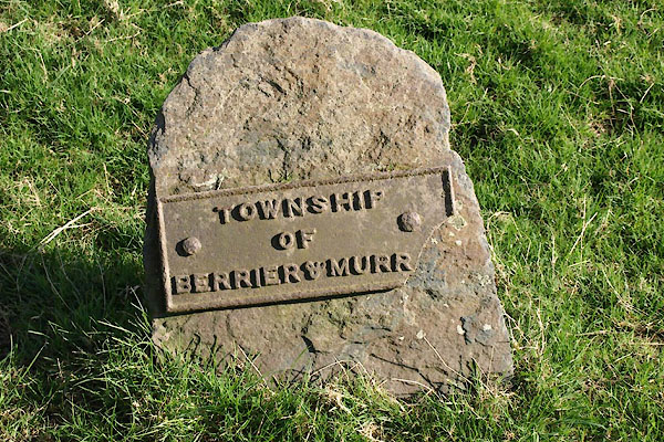 BWD70.jpg Cast iron:- "TOWNSHIP / OF / BERRIER &MURR[ ]" (taken 26.3.2012) |
||
|
|
||
| evidence:- | database:- Listed Buildings 2010 |
|
| source data:- | courtesy of English Heritage "BOUNDARY STONE WEST OF ENTRANCE TO LOW MILL FARMHOUSE / / / MUNGRISDALE / EDEN / CUMBRIA / II / 73537 / NY3664132546" |
|
| source data:- | courtesy of English Heritage "Boundary stone. Probably C19. Split slate stone with roughly-shaped head; cast-iron plate (cracked and one corner missing) inscribed TOWNSHIP OF BERRIER V MURRAH." |
|
|
|
||
| notes:- |
Note from Colin Smith, probably 1999. |
|
| Mungrisdale 00003 |
||
| OS County Series (Cmd 48 14) 'B.S' |
||
|
|
||
| Richardson, John: 1985: Local Historians Encyclopedia: Historical Publications (New
Barnet, Hertfordshire) Bulmer, T F: 1884: History, Topography and Directory of East Cumberland: Bulmer, T and Co (Manchester, Lancashire) Bulmer, T F: 1885: History, Topography, and Directory of Westmoreland: Bulmer, T and Co (Manchester, Lancashire) |
||
|
|
||
 Lakes Guides menu.