Old Cumbria Gazetteer
 |
 |
|
||
| road, Sedbergh to Orton | ||||
| Sedbergh to Orton | ||||
| Orton to Sedbergh | ||||
| locality:- | Sedbergh | |||
| civil parish:- | Sedbergh (formerly Yorkshire) | |||
| county:- | Cumbria | |||
| locality type:- | route | |||
| locality:- | Orton | |||
| civil parish:- | Orton S (formerly Westmorland) | |||
| county:- | Cumbria | |||
| locality type:- | route | |||
|
|
||||
| route parts:- |  Sedbergh to Kendal, to near Lincoln's Inn Bridge road, through Firbank Kendal to Tebay, from Dillicar Common Tebay to Appleby Sedbergh to Kendal, to near Lincoln's Inn Bridge road, through Firbank Kendal to Tebay, from Dillicar Common Tebay to Appleby |
|||
|
|
||||
| route parts:- | old route Howgill Lane, Sedbergh Fairmile Road, Tebay Kendal to Tebay, from Low Borrowbridge Tebay to Appleby |
|||
|
|
||||
| evidence:- | gradient diagram:- Gall and Inglis 1890s-1900s (Roads) |
|||
| source data:- | Contour Road Book of England, Northern Division, by Harry R G Inglis, published by
Gall and Inglis, 25 Paternoster Square, London and Edinburgh, 1898.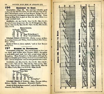 click to enlarge click to enlargeIG5196.jpg Itinerary, with gradient diagram, route 196, Sedbergh to Shap, and route 197, Barrow to Ravenglass, Westmorland, Yorkshire, Cumberland and Lancashire, 1898. item:- JandMN : 763.22 Image © see bottom of page |
|||
|
|
||||
| evidence:- | old strip map:- CTC 1911 (Roads) |
|||
| source data:- | Page 120 of Cyclists' Touring Club British Road Book new series vol.6, edited by F
B Sandford, published by Thomas Nelson and Sons, London etc, 1911.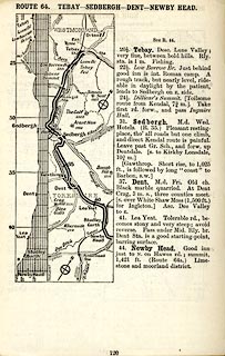 click to enlarge click to enlargeCTC2C0.jpg Strip road map, route 64, Tebay Sedbergh Dent Newby Head, part of Penrith to Newby Head, scale roughly 5 miles to 1 inch. Together with an itinerary and gradient diagram. item:- JandMN : 491.120 Image © see bottom of page |
|||
|
|
||||
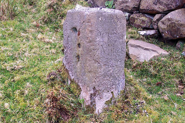
| evidence:- | old map, old map:- OS County series (Yrk 48) |
|||
| source data:- | "SEDBERGH TRUST" labelled at SD634922 OS County series (Yrk 63) "SEDBERGH TRUST" labelled at SD64679193 |
|||
|
|
||||
| places:- |
|
|||
|
||||
 Lakes Guides menu.