Old Cumbria Gazetteer
 |
 |
|
||
| road, Alston to Stanhope | ||||
| Alston to Stanhope | ||||
| Stanhope to Alston | ||||
| A689 | ||||
| civil parish:- | Alston Moor (formerly Cumberland) | |||
| county:- | Cumbria | |||
| locality type:- | route | |||
| 10Km square:- | NY74 | |||
| 10Km square:- | NY84 | |||
| county:- | Durham | |||
| locality type:- | route | |||
| 10Km square:- | NY84 (etc) | |||
|
|
||||
| evidence:- | road map:- Cary 1790 (Dhm/edn 1824) |
|||
| source data:- | Road map, hand coloured engraving, Durham, scale about 11.5 miles to 1 inch, by John
Cary, 181 Strand, 1790, edn published by G and J Cary, 86 St James's Street, London,
1824.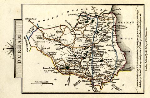 click to enlarge click to enlargeCY44.jpg double line, with road distances from Wolsingham item:- JandMN : 416 Image © see bottom of page |
|||
|
|
||||
| evidence:- | road map:- Cary 1790 (Cmd/edn 1789) |
|||
| source data:- | Road map, hand coloured engraving, Cumberland, scale about 15
miles to 1 inch, by John Cary, 181 Strand, London, 1790, edn
1789.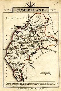 click to enlarge click to enlargeCY47.jpg "to Stanhope" double line item:- JandMN : 419 Image © see bottom of page |
|||
|
|
||||
| evidence:- | road book:- Cary 1798 (2nd edn 1802) |
|||
| source data:- | Road book, itineraries, Cary's New Itinerary, by John Cary, 181
Strand, London, 2nd edn 1802. goto source goto source click to enlarge click to enlargeC38319.jpg page 319-320 "At Aldstone Moor, on r. a T.R. to Wolsingham." item:- JandMN : 228.1 Image © see bottom of page |
|||
|
|
||||
| evidence:- | old map:- Cooke 1802 |
|||
| source data:- | Map, Cumberland, scale about 15.5 miles to 1 inch, by George
Cooke, 1802, bound in Gray's New Book of Roads, 1824, published
by Sherwood, Jones and Co, Paternoster Road, London, 1824. click to enlarge click to enlargeGRA1Cd.jpg "to Stanhope" double line, light dark dotted; unfenced road item:- Hampshire Museums : FA2000.62.2 Image © see bottom of page |
|||
|
|
||||
| evidence:- | old map:- Laurie and Whittle 1806 |
|||
| source data:- | Road map, Continuation of the Roads to Glasgow and Edinburgh,
scale about 10 miles to 1 inch, by Nathaniel Coltman? 1806,
published by Robert H Laurie, 53 Fleet Street, London, 1834. click to enlarge click to enlargeLw21.jpg light line; 'Other Direct Roads from LONDON' item:- private collection : 18.21 Image © see bottom of page |
|||
|
|
||||
| evidence:- | old map:- Cooper 1808 |
|||
| source data:- | Map, uncoloured engraving, Cumberland, scale about 10.5 miles to
1 inch, drawn and engraved by Cooper, published by R Phillips,
Bridge Street, Blackfriars, London, 1808. click to enlarge click to enlargeCOP3.jpg double line; road item:- JandMN : 86 Image © see bottom of page |
|||
|
|
||||
| evidence:- | old map:- Hall 1820 (Cmd) |
|||
| source data:- | Map, hand coloured engraving, Cumberland, scale about 21 miles
to 1 inch, engraved by Sidney Hall, published by S Leigh, 18
Strand, London, 1820-31. click to enlarge click to enlargeHA14.jpg single line, solid; minor road; Aldstone, Garrigilgate, Tyne Head, ... item:- JandMN : 91 Image © see bottom of page |
|||
|
|
||||
| evidence:- | gradient diagram:- Gall and Inglis 1890s-1900s (Roads) |
|||
| source data:- | Contour Road Book of England, Northern Division, by Harry R G Inglis, published by
Gall and Inglis, 25 Paternoster Square, London and Edinburgh, 1898.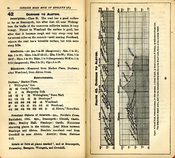 click to enlarge click to enlargeIG5042.jpg Itinerary, with gradient diagram, route 42, Durham to Alston, Durham and Cumberland, 1898. item:- JandMN : 763.4 Image © see bottom of page |
|||
|
|
||||
| evidence:- | old map:- Bell 1892 |
|||
| source data:- | Map, colour lithograph, Road Map of Cumberland, by George Joseph
Bell, scale about 2.5 miles to 1 inch, printed by Charles
Thurnam and Sons, Carlisle, Cumberland, 1892.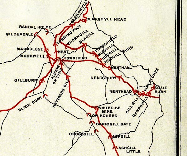 BEL9NY74.jpg 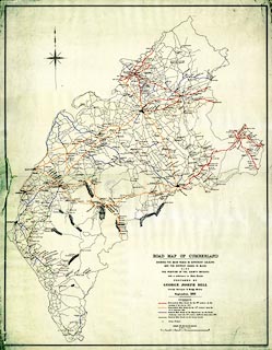 click to enlarge click to enlargeBEL9.jpg red - disturnpiked 'main road' under section 13 of the Highways Act 1878 Road map of Cumberland showing County Bridges item:- Carlisle Library : Map 38 Images © Carlisle Library |
|||
|
|
||||
| evidence:- | old strip map:- Geographia 1925 |
|||
| source data:- | Road book, with road strip maps and gradient diagrams, Premier Road Book of Great
Britain, by Alexander Gross and F Waite-Browne, published by Geographia, 55 Fleet
Street, London, about 1925?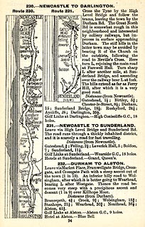 click to enlarge click to enlargeGE1094.jpg "232. - DURHAM TO ALSTON." item:- Hampshire Museums : B1990.161.4 Image © see bottom of page |
|||
|
|
||||
 Act of Parliament Act of Parliament |
||||
|
|
||||
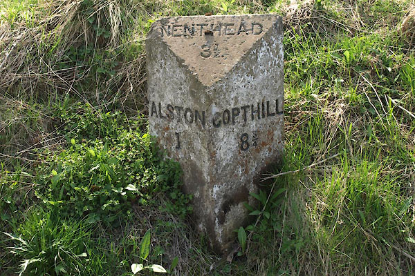
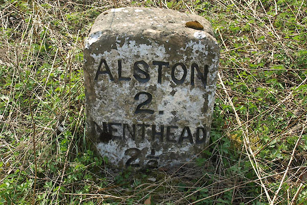
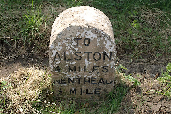
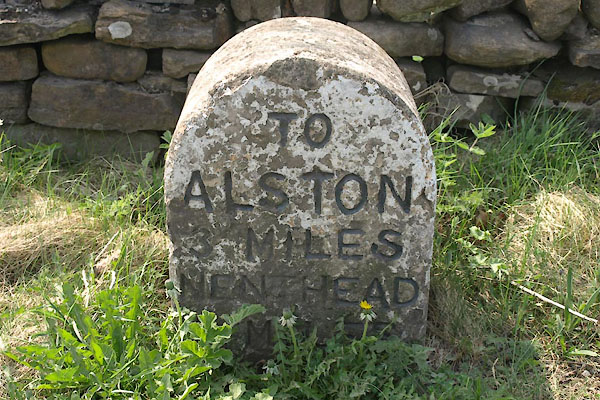
| places:- | Alston Nenthead Killhope Cross, Alston Moor Stanhope, Durham |
|||
|
|
||||
| places:- |
|
|||
|
||||
|
||||
|
||||
|
||||
Lakes Guides menu.