Old Cumbria Gazetteer
 |
 |
|
||
| road, Alston to Barnard Castle | ||||
| Alston to Barnard Castle | ||||
| Barnard Castle to Alston | ||||
| B6277 | ||||
| civil parish:- | Alston Moor (formerly Cumberland) | |||
| county:- | Cumbria | |||
| locality type:- | route | |||
| 10Km square:- | NY74 | |||
| 10Km square:- | NY73 | |||
| county:- | Durham | |||
| locality type:- | route | |||
| 10Km square:- | NY73 | |||
| 10Km square:- | NY83 (etc) | |||
|
|
||||
| evidence:- | old map:- Donald 1774 (Cmd) |
|||
| source data:- | Map, hand coloured engraving, 3x2 sheets, The County of Cumberland, scale about 1
inch to 1 mile, by Thomas Donald, engraved and published by Joseph Hodskinson, 29
Arundel Street, Strand, London, 1774.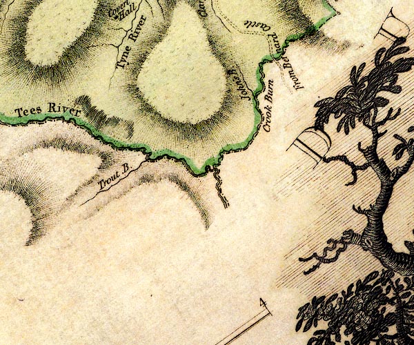 D4NY73SE.jpg "From Bernard Castle" road at county boundary item:- Carlisle Library : Map 2 Image © Carlisle Library |
|||
|
|
||||
| evidence:- | probably road map:- Cary 1790 (Dhm/edn 1824) |
|||
| source data:- | Road map, hand coloured engraving, Durham, scale about 11.5 miles to 1 inch, by John
Cary, 181 Strand, 1790, edn published by G and J Cary, 86 St James's Street, London,
1824. click to enlarge click to enlargeCY44.jpg double line item:- JandMN : 416 Image © see bottom of page |
|||
|
|
||||
| evidence:- | old map:- Laurie and Whittle 1806 |
|||
| source data:- | Road map, Continuation of the Roads to Glasgow and Edinburgh,
scale about 10 miles to 1 inch, by Nathaniel Coltman? 1806,
published by Robert H Laurie, 53 Fleet Street, London, 1834. click to enlarge click to enlargeLw21.jpg bold line; 'Principal Travelling Roads' item:- private collection : 18.21 Image © see bottom of page |
|||
|
|
||||
| evidence:- | old map:- Cooper 1808 |
|||
| source data:- | Map, uncoloured engraving, Cumberland, scale about 10.5 miles to
1 inch, drawn and engraved by Cooper, published by R Phillips,
Bridge Street, Blackfriars, London, 1808. click to enlarge click to enlargeCOP3.jpg double line; road item:- JandMN : 86 Image © see bottom of page |
|||
|
|
||||
| evidence:- | old map:- Wallis 1810 (Cmd) |
|||
| source data:- | Road map, hand coloured engraving, Cumberland, scale about 16
miles to 1 inch, by James Wallis, 77 Berwick Stree, Soho,
London, 1810. click to enlarge click to enlargeWL13.jpg "to Newcastle" double line, light bold; 'Turnpike Road' item:- Dove Cottage : 2009.81.10 Image © see bottom of page |
|||
|
|
||||
| evidence:- | old map:- Hall 1820 (Cmd) |
|||
| source data:- | Map, hand coloured engraving, Cumberland, scale about 21 miles
to 1 inch, engraved by Sidney Hall, published by S Leigh, 18
Strand, London, 1820-31. click to enlarge click to enlargeHA14.jpg single line, solid; minor road; Aldstone, Nentsbury, ... item:- JandMN : 91 Image © see bottom of page |
|||
|
|
||||
| evidence:- | gradient diagram:- Gall and Inglis 1890s-1900s (Roads) |
|||
| source data:- | Contour Road Book of England, Northern Division, by Harry R G Inglis, published by
Gall and Inglis, 25 Paternoster Square, London and Edinburgh, 1898.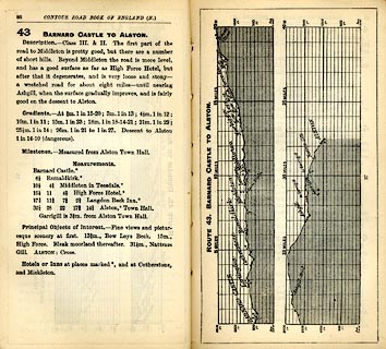 click to enlarge click to enlargeIG5043.jpg Itinerary, with gradient diagram, route 43, Barnard Castle to Alston, Cumberland and Durham, 1898. item:- JandMN : 763.5 Image © see bottom of page |
|||
|
|
||||
| evidence:- | old map:- Bell 1892 |
|||
| source data:- | Map, colour lithograph, Road Map of Cumberland, by George Joseph
Bell, scale about 2.5 miles to 1 inch, printed by Charles
Thurnam and Sons, Carlisle, Cumberland, 1892. BEL9NY74.jpg  BEL9NY73.jpg red - disturnpiked 'main road' under section 13 of the Highways Act 1878 Road map of Cumberland showing County Bridges item:- Carlisle Library : Map 38 Images © Carlisle Library |
|||
|
|
||||
| evidence:- | old itinerary:- Johnson 1908 (Roads/Cum) |
|||
| source data:- | Itinerary, Route 43 in Roads Made Easy by Picture and Pen, Doncaster to Glasgow, through
Alston, by Claude Johnson, edited by Lord Montagu, published by The Car Illustrated,
168 Piccadilly, London, 1908. click to enlarge click to enlargeJS5095.jpg pp.93-97 in the road book, Roads Made Easy by Picture and Pen, vol.3. printed at beginning, p.93:- "ROUTE 43. / DONCASTER via Boroughbridge (43½), Scotch Corner (72½), Barnard Castle (85½), Middleton-in-Teesdale (96½), Alston (118½), Longtown (148½), Gretna (155¼), to GLASGOW (240½)."  click to enlarge click to enlargeJS5096.jpg item:- private collection : 268.14 Image © see bottom of page |
|||
|
|
||||
| evidence:- | old itinerary:- Johnson 1908 (Roads/Cum) |
|||
| source data:- | Itinerary, Route 43 reverse in Roads Made Easy by Picture and Pen, Glasgow to Doncaster,
through Alston, by Claude Johnson, edited by Lord Montagu, published by The Car Illustrated,
168 Piccadilly, London, 1908. click to enlarge click to enlargeJS5102.jpg pp.98-106 in the road book, Roads Made Easy by Picture and Pen, vol.3. printed at beginning, p.98:- "ROUTE 43. Reverse. / GLASGOW via Gretna (85¼), Longtown (92), Alston (122), Middleton-in-Teesdale (144), Barnard Castle (155), Scotch Corner (168), Boroughbridge (197) to DONCASTER 240½)." item:- private collection : 268.15 Image © see bottom of page |
|||
|
|
||||
| evidence:- | old strip map:- CTC 1911 (Roads) |
|||
| source data:- | Page 84 of Cyclists' Touring Club British Road Book new series vol.6, edited by F
B Sandford, published by Thomas Nelson and Sons, London etc, 1911.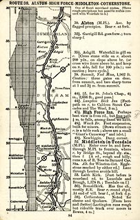 click to enlarge click to enlargeCTC284.jpg Strip road map, route 38, Alston High Force, Middleton Cotherstone, part of Longtown to Catterick Bridge, scale roughly 5 miles to 1 inch. Together with an itinerary and gradient diagram. item:- JandMN : 491.84 Image © see bottom of page |
|||
|
|
||||
| evidence:- | old strip map:- Geographia 1925 |
|||
| source data:- | Road book, with road strip maps and gradient diagrams, Premier Road Book of Great
Britain, by Alexander Gross and F Waite-Browne, published by Geographia, 55 Fleet
Street, London, about 1925?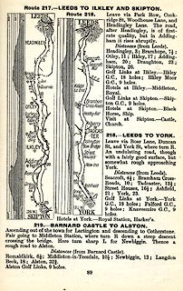 click to enlarge click to enlargeGE1089.jpg "219. - BARNARD CASTLE TO ALSTON." item:- Hampshire Museums : B1990.161.4 Image © see bottom of page |
|||
|
|
||||
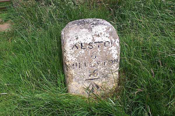
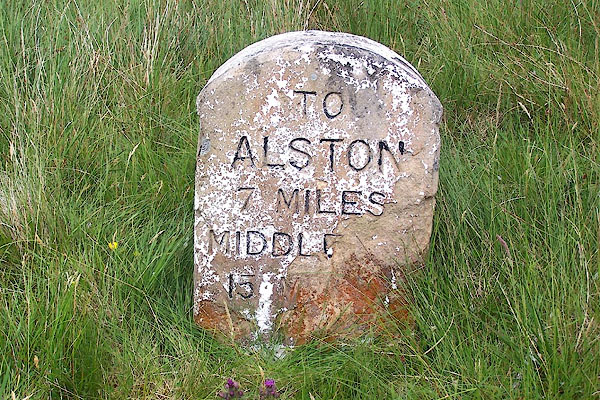
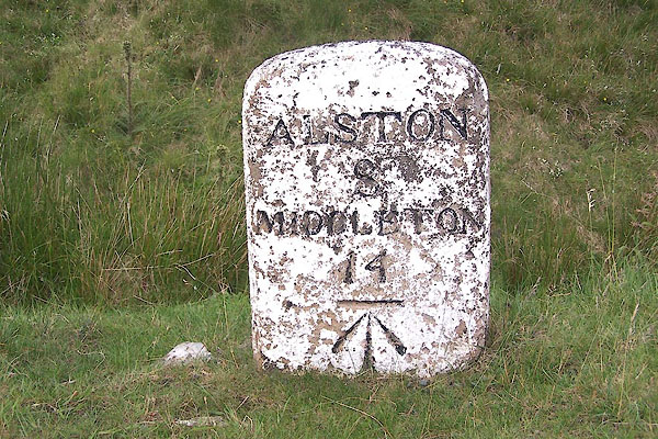
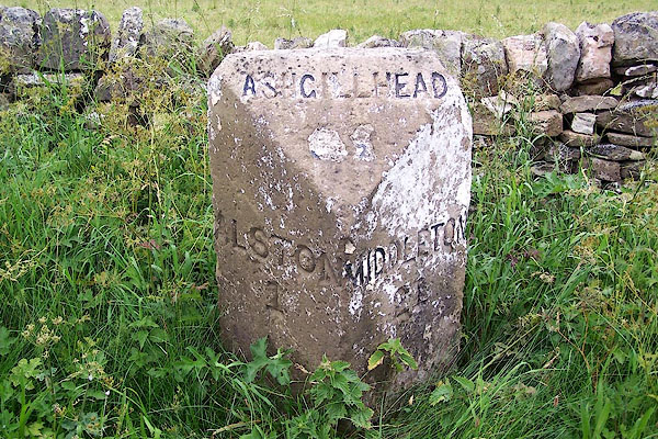
| places:- |  Alston Middleton-in-Teesdale, Durham Alston Middleton-in-Teesdale, Durham[Mickleton, Durham] Barnard Castle, Durham |
|||
|
|
||||
| places:- |
|
|||
|
||||
|
||||
|
||||
|
||||
|
||||
|
||||
|
||||
|
||||
|
||||
|
||||
|
||||
|
||||
Lakes Guides menu.