 Old Cumbria Gazetteer
 |
 |
|
| milestone, Alston Moor (23) | ||
| site name:- | road, Alston to Barnard Castle | |
| civil parish:- | Alston Moor (formerly Cumberland) | |
| county:- | Cumbria | |
| locality type:- | milestone | |
| coordinates:- | NY78674356 | |
| 1Km square:- | NY7843 | |
| 10Km square:- | NY74 | |
| references:- | OS County Series |
|
|
|
||
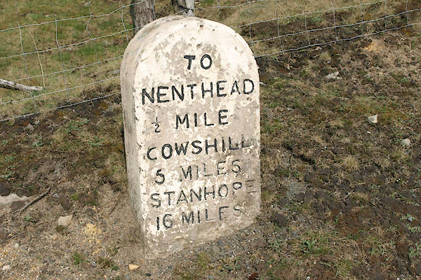 BUJ89.jpg Inscribed stone:- "TO / NENTHEAD ½MILE / COWSHILL / 5 MILES / STANHOPE / 16 MILES" (taken 23.4.2011) |
||
|
|
||
| evidence:- | old map:- OS County Series (Cmd 42 3) |
|
| source data:- | Maps, County Series maps of Great Britain, scales 6 and 25
inches to 1 mile, published by the Ordnance Survey, Southampton,
Hampshire, from about 1863 to 1948. "Alston .. 5 M.S" |
|
|
|
||
| evidence:- | database:- Listed Buildings 2010 |
|
| source data:- | courtesy of English Heritage "MILESTONE TO NORTH EAST OF HILLTOP / / A689 / ALSTON MOOR / EDEN / CUMBRIA / II / 73096 / NY7870643545" |
|
| source data:- | courtesy of English Heritage "Milestone, early C19 for Alston Turnpike Trust. Single stone c2 ft high by c1 1/2 ft wide with semicircular top; painted white with carved sans-serif lettering on front face picked out in black: TO NENTHEAD 1/2 MILE, COWSHILL 5 MILES, STANHOPE 16 MILES." |
|
|
|
||
 Lakes Guides menu.