 Old Cumbria Gazetteer
 |
 |
|
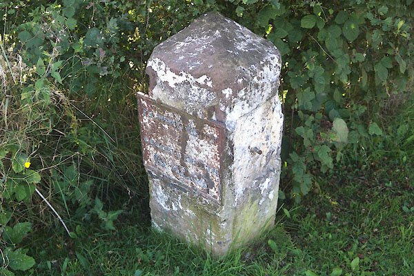
| milestone, Distington (2) | ||
| site name:- | road, Cockermouth to Whitehaven | |
| locality:- | Common End | |
| locality:- | Distington | |
| civil parish:- | Distington (formerly Cumberland) | |
| county:- | Cumbria | |
| locality type:- | milestone | |
| coordinates:- | NY00522290 | |
| 1Km square:- | NY0022 | |
| 10Km square:- | NY02 | |
| references:- | OS County Series |
|
|
|
||
 CFL53.jpg (taken 2.9.2016) 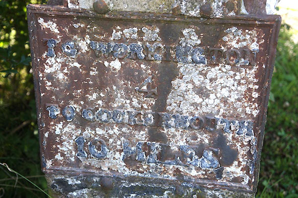 CFL54.jpg (taken 2.9.2016) |
||
|
|
||
| evidence:- | old map:- OS County Series (Cmd 61 7) |
|
| source data:- | Maps, County Series maps of Great Britain, scales 6 and 25
inches to 1 mile, published by the Ordnance Survey, Southampton,
Hampshire, from about 1863 to 1948. "Whitehaven .. 4 Workington .. 4 Cockermouth .. 10 M.S" |
|
|
|
||
| evidence:- | database:- Listed Buildings 2010 |
|
| source data:- | courtesy of English Heritage "MILESTONE TO NORTH OF BOOT BRIDGE / / A595 / DISTINGTON / COPELAND / CUMBRIA / II / 76115 / NY0053022902" |
|
| source data:- | courtesy of English Heritage "Milestone, mid C19. Single sandstone block c2 ft high with chamfered top; square in plan, set diagonally to road. Painted white with rectangular cast-iron plate to south face; border and raised sans-serif lettering picked out in black TO WORKINGTON 4 TO COCKERMOUTH 10 MILES. Plate missing from north face." |
|
|
|
||
 Lakes Guides menu.