 Old Cumbria Gazetteer
 |
 |
|
| school, Measandbecks | ||
| flooded | ||
| Measandbecks School | ||
| Measand School | ||
| locality:- | Measandbecks | |
| locality:- | Measand | |
| civil parish:- | Bampton (formerly Westmorland) | |
| county:- | Cumbria | |
| locality type:- | school (gone) | |
| coordinates:- | NY48741523 (guess) | |
| 1Km square:- | NY4815 | |
| 10Km square:- | NY41 | |
| references:- | OS County Series |
|
|
|
||
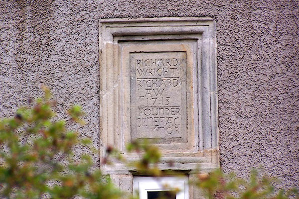 BJW39.jpg Plaque from the school:- "RICHARD WRIGHT / RICHARD LAW / 1713 / FOUNDER BENEFACTOR" now at Walmgate Head, Brampton. (taken 29.9.2005) |
||
|
|
||
| evidence:- | old map:- OS County Series (Wmd 13 15) |
|
| source data:- | Maps, County Series maps of Great Britain, scales 6 and 25
inches to 1 mile, published by the Ordnance Survey, Southampton,
Hampshire, from about 1863 to 1948. "School (Endowed)" |
|
|
|
||
| evidence:- | possibly old text:- Gents Mag |
|
| source data:- | Magazine, The Gentleman's Magazine or Monthly Intelligencer or
Historical Chronicle, published by Edward Cave under the
pseudonym Sylvanus Urban, and by other publishers, London,
monthly from 1731 to 1922. goto source goto sourceGentleman's Magazine 1823 part 2 p.324 "MEASAND, in the parish of Bampton, founded in 1711, by Mr. Richard Wright, and endowed by him with a messuage and lands at Nether Scales in the parish of Orton. In 1723 Richard Law of Cawdale in this parish (great uncle of Bishop Law), gave a garth, in which the school stands." |
|
|
|
||
| hearsay:- |
Founded by Richard Wright, 1713; room for a dozen pupils. |
|
| When the valley was flooded by Hawes Water Reservoir, the school was rebuilt as Walmgate
Head, Brampton, opposite Thornthwaite Hall. |
||
|
|
||
| see:- | Walmgate Head, Bampton |
|
|
|
||
Lakes Guides menu.