 Old Cumbria Gazetteer
 |
 |
|
| Megs Gill | ||
| runs into:- |  Great Langdale Beck Great Langdale Beck |
|
|
|
||
| Meg's Gill | ||
| locality:- | Chapel Stile | |
| locality:- | Great Langdale | |
| civil parish:- | Lakes (formerly Westmorland) | |
| county:- | Cumbria | |
| locality type:- | river | |
| 1Km square:- | NY3206 (etc) | |
| 10Km square:- | NY30 | |
|
|
||
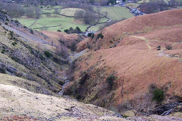 BVX05.jpg (taken 15.2.2012) |
||
|
|
||
| evidence:- | old map:- OS County Series (Wmd 25 8) placename:- Megs Gill |
|
| source data:- | Maps, County Series maps of Great Britain, scales 6 and 25
inches to 1 mile, published by the Ordnance Survey, Southampton,
Hampshire, from about 1863 to 1948. |
|
|
|
||
| evidence:- | outline view:- Martineau 1855 placename:- Meg's Gill |
|
| source data:- | Print, engraving, outline view, Mountains seen a little beyond Rydal Mount, drawn
by L Aspland, engraved by W Banks, Edinburgh, published by John Garnett, Windermere,
Westmorland, and by Whittaker and Co, London, 1855.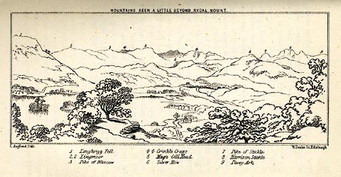 click to enlarge click to enlargeMNU109.jpg Opposite p.64 in A Complete Guide to the English Lakes, by Harriet Martineau. "MOUNTAINS SEEN A LITTLE BEYOND RYDAL MOUNT." "L Aspland Delt. / W Banks Sc Edinr." The view is captioned, numbers referring to mountains in the image:- "1 Loughrigg Fell, 2 Lingmoor, 3 Pike of Bliscow, 4 Crinkle Crags, 5 Meg's Gill Head, 6 Silver How, 7 Pike of Stickle, 8 Harrison Stickle, 9 Pavey Ark" item:- Armitt Library : A1159.9 Image © see bottom of page |
|
|
|
||
Lakes Guides menu.