 Old Cumbria Gazetteer
 |
 |
|
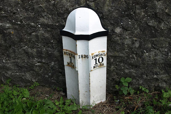
| milestone, Burton-in-Kendal (3) | ||
| site name:- | road, Lancaster to Kendal E | |
| civil parish:- | Burton-in-Kendal (formerly Westmorland) | |
| county:- | Cumbria | |
| locality type:- | milestone | |
| coordinates:- | SD52997804 | |
| 1Km square:- | SD5278 | |
| 10Km square:- | SD57 | |
| references:- | OS 2000s Explorer |
|
|
|
||
 BZB71.jpg (taken 16.8.2013) |
||
|
|
||
| evidence:- | old map:- OS County Series (Wmd 47) |
|
| source data:- | Maps, County Series maps of Great Britain, scales 6 and 25
inches to 1 mile, published by the Ordnance Survey, Southampton,
Hampshire, from about 1863 to 1948. "MS.S BURTON 1 KENDAL 10" |
|
|
|
||
| evidence:- | old map:- Jefferys 1770 (Wmd) |
|
| source data:- | Map, 4 sheets, The County of Westmoreland, scale 1 inch to 1
mile, surveyed 1768, and engraved and published by Thomas
Jefferys, London, 1770.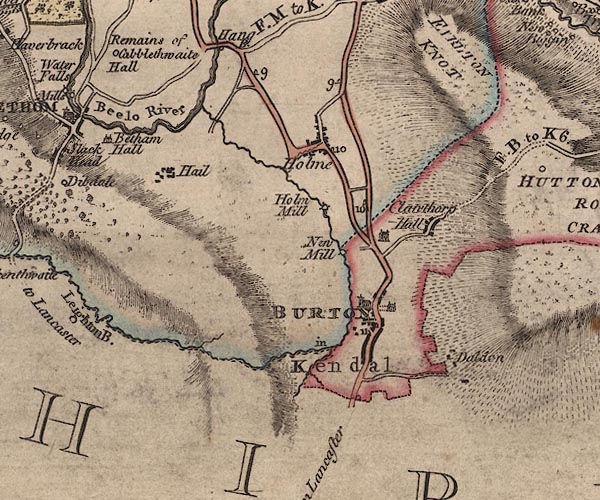 J5SD57NW.jpg "10" milestone marked by road item:- National Library of Scotland : EME.s.47 Image © National Library of Scotland |
|
|
|
||
| evidence:- | database:- Listed Buildings 2010 |
|
| source data:- | courtesy of English Heritage "MILEPOST APPROXIMATELY 400 METRES NORTH NORTH WEST OF CLAWTHORPE HALL / / A6070 / BURTON IN KENDAL / SOUTH LAKELAND / CUMBRIA / DL / 76639 / SD5298378058" |
|
| source data:- | courtesy of English Heritage "Milepost. Dated 1826. Cast-iron. Half-hexagonal with fluted faces and domed top. Painted black and white. Marked:" "BURTON / 1 / MILE" "on the North side and" "KENDAL / 10/ MILES" "on the South side." "One of a series of similar milestones and boundary stones on the Heronsyke Turnpike, for which the work was supervised by John McAdam." |
|
|
|
||
 Lakes Guides menu.