 Old Cumbria Gazetteer
 |
 |
|
| Allhallows, Kendal | ||
| Allhallows Chapel | ||
| locality:- | Kendal | |
| civil parish:- | Kendal (formerly Westmorland) | |
| county:- | Cumbria | |
| locality type:- | church | |
| locality type:- | chapel | |
| coordinates:- | SD513925 (?) | |
| 1Km square:- | SD5192 | |
| 10Km square:- | SD59 | |
| references:- | Nurse 1918 |
|
|
|
||
| evidence:- | old map:- Speed 1611 placename:- Allhallowes Chappel |
|
| source data:- | Map, hand coloured engraving, The Countie Westmorland and
Kendale the Cheif Towne, scale about 2.5 miles to 1 inch, by
John Speed, 1610, published by George Humble, Popes Head Alley,
London, 1611-12.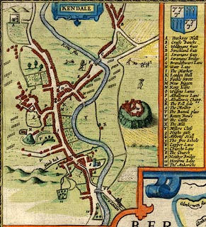 click to enlarge click to enlargeSP14Mk.jpg "Q Allhallowes Chapp." building item:- Armitt Library : 2008.14.5 Image © see bottom of page |
|
|
|
||
| evidence:- | old map:- Nurse 1918 |
|
| source data:- | Map, The Diocese of Carlisle, Cumberland, Westmorland, and
Lancashire North of the Sands, scale about 4 miles to 1 inch, by
Rev Euston J Nurse, published by Charles Thurnam and Sons, 11
English Street, Carlisle, Cumberland, 2nd edn 1939.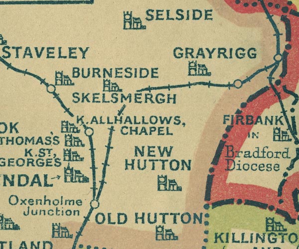 NUR1SD59.jpg "KENDAL ALLHALLOWS CHAPEL" item:- JandMN : 27 Image © see bottom of page |
|
|
|
||
 Lakes Guides menu.