 Old Cumbria Gazetteer
 |
 |
|
| milestone, Boltons (2) | ||
| site name:- | road, Cockermouth to Carlisle | |
| locality:- | Bolton Low Houses | |
| civil parish:- | Boltons (formerly Cumberland) | |
| county:- | Cumbria | |
| locality type:- | milestone | |
| coordinates:- | NY23664425 | |
| 1Km square:- | NY2344 | |
| 10Km square:- | NY24 | |
|
|
||
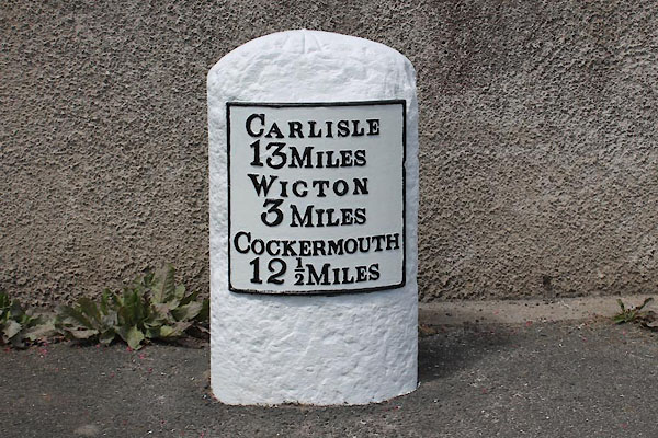
 BNO32.jpg Cast iron plate on a stone:- "[CARLISLE 13 MILES WIGTON 3 MILES COCKERMOUTH 12½MILES]" (taken 11.4.2007) |
||
|
|
||
| evidence:- | old map:- OS County Series (Cmd 37 1) |
|
| source data:- | Maps, County Series maps of Great Britain, scales 6 and 25
inches to 1 mile, published by the Ordnance Survey, Southampton,
Hampshire, from about 1863 to 1948. "Wigton ... 3 Cockermouth ... 12 1/2 Carlisle ... 14 M.S" |
|
|
|
||
| evidence:- | database:- Listed Buildings 2010 |
|
| source data:- | courtesy of English Heritage "MILESTONE / / A595 / BOLTONS / ALLERDALE / CUMBRIA / II / 72335 / NY2366444258" |
|
| source data:- | courtesy of English Heritage "Milestone. Late C18 or early C19 for the Carlisle-Cockermouth Turnpike. Red sandstone, cast-iron plate. Rounded-top stone with curved face, plate to front with raised letters CARLISLE 13 MILES, WIGTON 3 MILES, COCKERMOUTH 12 1/2 MILES. Whitewashed and lettering picked out in black. O.S. bench mark on top of stone." |
|
|
|
||
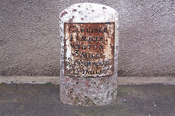
 CEL68.jpg Cast iron plate on stone:- "CARLISLE / 13 MILES / WIGTON / 3 MILES / COCKERMOUTH / 12½MILES" (taken 6.2014) courtesy of Terry Moore Image © Terry Moore |
||
|
|
||
 Lakes Guides menu.