 Old Cumbria Gazetteer
 |
 |
|
| viewpoint, Red Bank | ||
| locality:- | High Close | |
| locality:- | Red Bank | |
| civil parish:- | Lakes (formerly Westmorland) | |
| county:- | Cumbria | |
| locality type:- | viewpoint | |
| coordinates:- | NY340055 (?) | |
| 1Km square:- | NY3405 | |
| 10Km square:- | NY30 | |
|
|
||
| evidence:- | outline view:- Otley 1823 (5th edn 1834) |
|
| source data:- | Print, woodcut outline view, The Mountains of Grasmere and Rydal, by Jonathan Otley,
Keswick, Cumberland now Cumbria, 1834.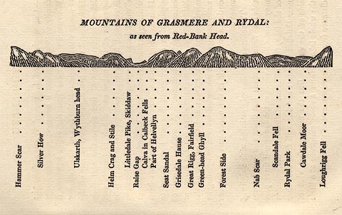 click to enlarge click to enlargeOT2E03.jpg Printed on p.15 of A Concise Description of the English Lakes, by Jonathan Otley, 5th edition, 1834. printed at top:- "THE MOUNTAINS OF GRASMERE AND RYDAL: as seen from Red-Bank Head." printed at bottom:- "Hammer Scar / Silver How / Ulskarth, Wythburn head / Helm Crag and Stile / Littledale Pike, Skiddaw / Raise Gap / Calva in Caldbeck Fells / Part of Helvellyn / Seat Sandal / Grisedale Hause / Great Rigg, Fairfield / Green-head Ghyll / Forest Side / Nab Scar / Scandale Fell / Rydal Park / Cawdale Moor / Loughrigg Fell" item:- JandMN : 48.4 Image © see bottom of page |
|
|
|
||
| evidence:- | outline view:- Otley 1823 (8th edn 1849) |
|
| source data:- | Print, engraving, outline view of mountains, Grasmere from Red Bank Head, drawn by
Mr Binns, Halifax, engraved by Mr Jewitt, Headington, Oxfordshire, published by Jonathan
Otley, Keswick, Cumberland et al, 1849.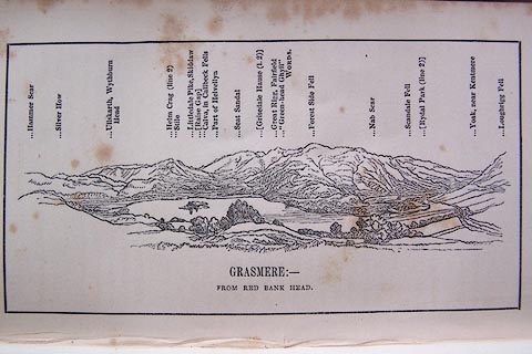 click to enlarge click to enlargeO80E04.jpg Opposite p.4 of A Descriptive Guide of the English Lakes, by Jonathan Otley, 8th edition, 1849. printed at bottom:- "GRASMERE: - FROM RED BANK HEAD." printed at top:- "Hammer Scar / Silver How / Ullskarth, Wythburn Head / Helm Crag (line 2) / Stile / Littledale Pike, Skiddaw / (Raise Gap) / Calva, in Caldbeck Fells / Part of Helvellyn / Seat Sandal / (Grisedale Hause (l.2)) / Great Rigg, Fairfield / 'Green-head Ghyll' WORDS. / Forest Side Fell / Nab Scar / Scandale Fell / (Rydal Park (line 2)) / Yoak, near Kentmere / Loughrigg Fell" Looking N; 200 degree view, WSW to E. item:- Armitt Library : A1180.5 Image © see bottom of page |
|
|
|
||
| evidence:- | old text:- Martineau 1855 |
|
| source data:- | Guide book, A Complete Guide to the English Lakes, by Harriet
Martineau, published by John Garnett, Windermere, Westmorland,
and by Whittaker and Co, London, 1855; published 1855-76. goto source goto sourcePage 48:- "... He may leave his car where the road to High Close ascends to the left, and walk to the farm-house at the top. As there are probably lodgers, he had better not present himself at the garden door, but go on to the farmyard gate, pass through the yard to the field, and walk along the brow till he reaches the grey stone bench. There he is! overlooking "the finest view in Westmorland." To the extreme right, Bowfell closes in the Langdale valley, the head of which is ennobled by the swelling masses of the Pikes. A dark cleft in the nearer one is the place where the celebrated Dungeon Ghyll Force is plunging and foaming, beyond the reach of eye and ear. He can gather from this station, something of the character of Langdale. It has levels, here expanding, there contracting; and the stream winds among them from end to end. There is no lake: and the mountains send out spurs, alternating or meeting, so as to make the levels sometimes circular and sometimes winding. The dwellings are on the rising grounds which skirt the levels; and this, together with the paving of the road below, shows that the valley is subject to floods. The houses, of grey-stone, each on its knoll, with a canopy of firs and sycamores above it, and ferns scattered all around, and ewes and lambs nestling near it,- these primitive farms are cheerful and pleasant objects to look upon, whether from above or passing among them. Nearer at hand are some vast quarries of blue slate. Below, among plantations, are seen the roofs of the Elterwater Powder Mills; whence the road winds through the village of Langdale Chapel, to the margin" goto sourcePage 49:- "of the pools which make up the lake. From their opposite shore rise the hills, height above height, range beyond range. To the left lies Loughrigg Tarn, and, in the distance, Windermere, with Wray Castle prominent on its height, and the Lancashire hills closing in the view. It is a singular prospect, at once noble and lovely; ..." |
|
|
|
||
| evidence:- | old print:- Martineau 1855 |
|
| source data:- | Plate, opposite p.49:- goto source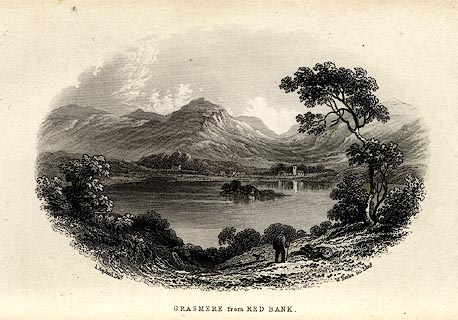 click to enlarge click to enlargeMNU107.jpg Print, engraving, Grasmere from Red Bank, drawn by L Aspland, engraved by W Banks, Edinburgh, published by John Garnett, Windermere, Westmorland, and by Whittaker and Co, London, 1855. "L Aspland Delt. / W Banks Sc Edinr. / GRASMERE from RED BANK." item:- Armitt Library : A1159.7 Image © see bottom of page |
|
|
|
||
| evidence:- | old text:- Martineau 1855 |
|
| source data:- | Guide book, A Complete Guide to the English Lakes, by Harriet
Martineau, published by John Garnett, Windermere, Westmorland,
and by Whittaker and Co, London, 1855; published 1855-76. goto source Page 49:- "... he had better walk for half-a-mile or so,- the descent of Red Bank being very steep. The great mountain that swells so grandly above the rest before him is Helvellyn. The lake that opens below is Grasmere, with its one island, made up of green slope, black fir clump, and grey barn. At the further end lies the village, with its old square church tower, beneath whose shadow Wordsworth is buried. The white road that winds like a ribbon up and up the gap between Helvellyn and the opposite fells is the mail road to Keswick, and the gap is Dunmail Raise. The remarkable and beautiful hill behind the village is Helm Crag; and its rocky crest forms the group called the Lion and the Lamb. The long white house, near the foot of Helvellyn, is the Swan Inn, whence Scott, Southey, and Wordsworth, set forth on ponies for the ascent of the mountain: and behind it rises the path by which pedestrians come from Grasmere to Patterdale, by the margin of Grisedale tarn, the mountain tarn of the wild boar, as the words properly signify. To the left of Helm Crag, a deep valley evidently opens. That is Easedale;" |
|
|
|
||
Lakes Guides menu.