 Old Cumbria Gazetteer
 |
 |
|
| viewpoint, Measand Beck | ||
| locality:- | Measandbecks (now drowned) | |
| locality:- | Measand | |
| civil parish:- | Bampton (formerly Westmorland) | |
| county:- | Cumbria | |
| locality type:- | viewpoint | |
| coordinates:- | NY487154 (now drowned) | |
| 1Km square:- | NY4815 | |
| 10Km square:- | NY41 | |
|
|
||
| evidence:- | outline view:- Otley 1823 (8th edn 1849) |
|
| source data:- | Print, engraving, outline view of mountains, Hawes Water from Measand Beck, drawn
by Mr Binns, Halifax, engraved by Mr Jewitt, Headington, Oxfordshire, published by
Jonathan Otley, Keswick, Cumberland et al, 1849.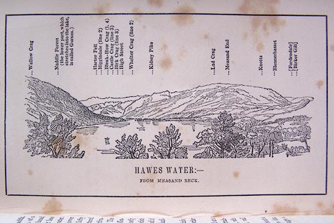 click to enlarge click to enlargeO80E09.jpg Opposite p.16 of A Descriptive Guide of the English Lakes, by Jonathan Otley, 8th edition, 1849. printed at bottom:- "HAWES WATER: - / FROM MEASAND BECK." printed at top:- "Wallow Crag / Naddle Forest (the lower part, which stretches into the lake, is called Gurnes.) / Harter Fell / Riggindale (line 2) / Bleak-How Crag (l.4) / Castle Crag (line 3) / High Street / Whelter Crag (line 2) / Kidsey Pike / Lad Crag / Measand End / Knotts / Blennerhasset / (Fordendale) / (Birker Gill)" Looking SW; 180 degree view, ESE to WNW. item:- Armitt Library : A1180.10 Image © see bottom of page |
|
|
|
||
 Lakes Guides menu.