 Old Cumbria Gazetteer
 |
 |
|
| Hesket Gate Turnpike, Hesket | ||
| gone | ||
| Hesket Gate | ||
| site name:- | road, Penrith to Carlisle | |
| civil parish:- | Hesket (formerly Cumberland) | |
| county:- | Cumbria | |
| locality type:- | toll gate (site) | |
| coordinates:- | NY47104529 | |
| 1Km square:- | NY4745 | |
| 10Km square:- | NY44 | |
| references:- | OS County Series |
|
|
|
||
| evidence:- | old map:- OS County Series (Cmd 31 14) |
|
| source data:- | Maps, County Series maps of Great Britain, scales 6 and 25
inches to 1 mile, published by the Ordnance Survey, Southampton,
Hampshire, from about 1863 to 1948. "Hesket Gate (T.P.)" at a junction; line across the main road road on the N side, possibly across the side road, no obvious building. |
|
|
|
||
| evidence:- | old map:- Burrow 1920s |
|
| source data:- | Road book, On the Road, Dunlop Pictorial Road Plans, volume V,
strip maps with parts in Westmorland, Cumberland etc, irregular
scale about 1.5 miles to 1 inch, by E J Burrow and Co,
Cheltenham, Gloucestershire, 1920s.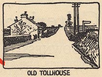 EJB3Vg26.jpg item:- private collection : 17 Image © see bottom of page |
|
|
|
||
 Lakes Guides menu.