 Old Cumbria Gazetteer
 |
 |
|
| milestone, Wetheral (3) | ||
| site name:- | road, Carlisle to Brampton S | |
| locality:- | Warwick-on-Eden | |
| civil parish:- | Wetheral (formerly Cumberland) | |
| county:- | Cumbria | |
| locality type:- | milestone | |
| coordinates:- | NY46445658 | |
| 1Km square:- | NY4656 | |
| 10Km square:- | NY45 | |
|
|
||
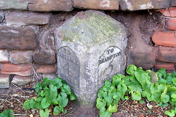 BMN75.jpg Cast iron plates on stone:- "TO CARLISLE 4 MILES / TO BRAMPTON 5 MILES" (taken 25.8.2006) |
||
|
|
||
| evidence:- | old map:- OS County Series (Cmd 24 2) |
|
| source data:- | Maps, County Series maps of Great Britain, scales 6 and 25
inches to 1 mile, published by the Ordnance Survey, Southampton,
Hampshire, from about 1863 to 1948. "Carlisle 4 Brampton 5 M.S." |
|
|
|
||
| evidence:- | database:- Listed Buildings 2010 |
|
| source data:- | courtesy of English Heritage "MILESTONE / / A69 / WETHERAL / CARLISLE / CUMBRIA / II / 77743 / NY4644656561" |
|
| source data:- | courtesy of English Heritage "Milestone. 1830 for Carlisle to Brampton Turnpike Trust. Red sandstone and cast iron. Squared stone with pyramidal top, set at angle to road to give 2 faces in direction of traffic. Cast plates set into each face, that pointing east is inscribed TO CARLISLE 4 MILES and west TO BRAMPTON 5 MILES. Has metal stud on top, with bench mark. Whitewashed with lettering picked out in black." |
|
|
|
||
 Lakes Guides menu.