 Old Cumbria Gazetteer
 |
 |
|
| milestone, Glassonby (4) | ||
| site name:- | road, Penrith to Alston | |
| civil parish:- | Glassonby (formerly Cumberland) | |
| county:- | Cumbria | |
| locality type:- | milestone | |
| coordinates:- | NY65704226 | |
| 1Km square:- | NY6542 | |
| 10Km square:- | NY64 | |
|
|
||
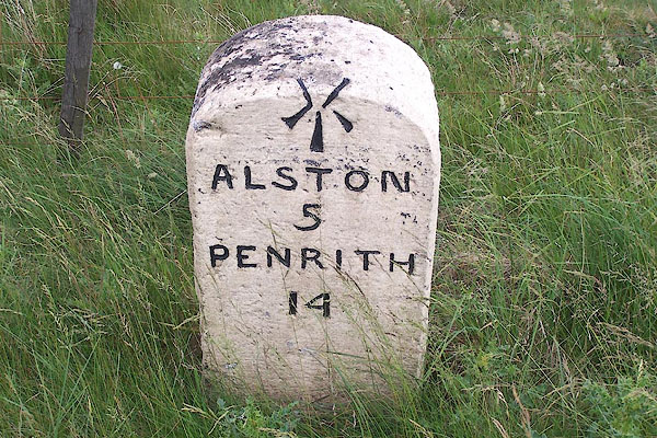 BMI90.jpg Inscribed stone:- "ALSTON 5 / PENRITH 14" and a cut bench mark. (taken 7.7.2006) |
||
|
|
||
| evidence:- | old map:- OS County Series (Cmd 41 6) |
|
| source data:- | Maps, County Series maps of Great Britain, scales 6 and 25
inches to 1 mile, published by the Ordnance Survey, Southampton,
Hampshire, from about 1863 to 1948. "M.S. Alston .. 5 Penrith .. 14" |
|
|
|
||
| evidence:- | database:- Listed Buildings 2010 |
|
| source data:- | courtesy of English Heritage "MILESTONE EAST OF HARTSIDE CAFE / / A686 / GLASSONBY / EDEN / CUMBRIA / II / 73447 / NY6570442257" |
|
| source data:- | courtesy of English Heritage "Milestone. Probably early C19 for the Penrith-Alston Turnpike. Whitewashed stone. Round top squared stone, has incised lettering on face ALSTON 5, PENRITH 14, in 4 lines, picked out in black, with bench mark above." |
|
|
|
||
 Lakes Guides menu.