 Old Cumbria Gazetteer
 |
 |
|
| Cow Green Reservoir, Dufton | ||
| Cow Green Reservoir | ||
| Cow Green Dam | ||
| civil parish:- | Dufton (formerly Westmorland) | |
| county:- | Cumbria | |
| locality type:- | reservoir | |
| locality type:- | lake | |
| locality type:- | dam | |
| coordinates:- | NY80503020 (etc) | |
| 1Km square:- | NY8030 | |
| 10Km square:- | NY83 | |
| altitude:- | 1604 feet (top water level) | |
| altitude:- | 489m (top water level) | |
| county:- | Durham | |
| current boundary | ||
| locality:- | Cumbria boundary | |
|
|
||
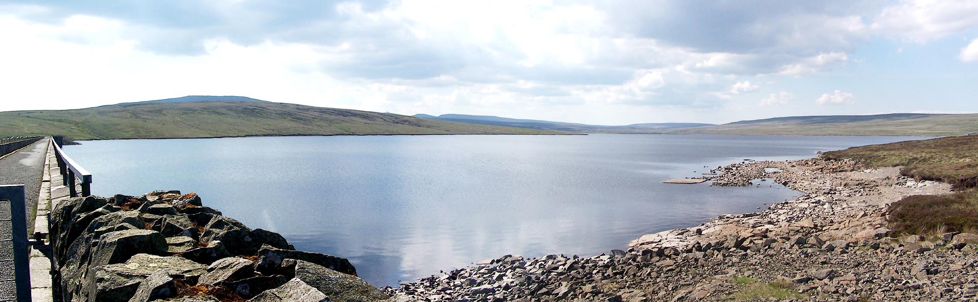 Click to enlarge BQS27.jpg (taken 1.6.2009) 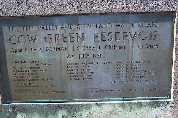 BQS24.jpg Plaque:- "THE TEES VALLEY AND CLEVELAND WATER BOARD / COW GREEN RESERVOIR / Opened ... / 22nd JULY 1971 / ... / Consulting engineers Rote, Kennard and Lapworth Westminster / Contractors The Mitchell Construction Company Ltd Peterborough" (taken 1.6.2009) |
||
|
|
||
| evidence:- | old map:- OS County Series (Wmd 6 8) placename:- Weel, The |
|
| source data:- | Maps, County Series maps of Great Britain, scales 6 and 25
inches to 1 mile, published by the Ordnance Survey, Southampton,
Hampshire, from about 1863 to 1948. OS County Series (Wmd 6 12) Stretch of river. |
|
|
|
||
| evidence:- | old map:- Jefferys 1770 (Wmd) placename:- Weel, The |
|
| source data:- | Map, 4 sheets, The County of Westmoreland, scale 1 inch to 1
mile, surveyed 1768, and engraved and published by Thomas
Jefferys, London, 1770.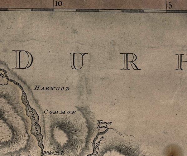 J5NY83SW.jpg "The Weel" outline with form lines; lake or tarn; on county boundary item:- National Library of Scotland : EME.s.47 Image © National Library of Scotland |
|
|
|
||
| evidence:- | old map:- Cary 1789 (edn 1805) |
|
| source data:- | Map, uncoloured engraving, Westmoreland, scale about 2.5 miles
to 1 inch, by John Cary, London, 1789; edition 1805.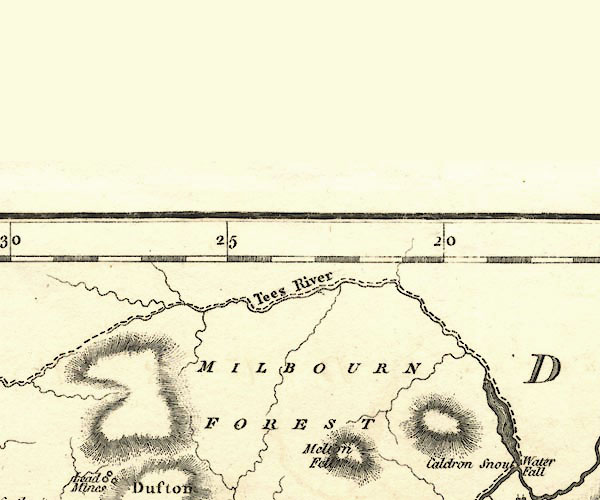 CY24NY73.jpg outline with shore form lines; lake or tarn item:- JandMN : 129 Image © see bottom of page |
|
|
|
||
| evidence:- | old map:- Cooke 1802 |
|
| source data:- | Map, Westmoreland ie Westmorland, scale about 12 miles to 1
inch, by George Cooke, 1802, published by Sherwood, Jones and
Co, Paternoster Road, London, 1824. click to enlarge click to enlargeGRA1Wd.jpg outline with form lines; lake or tarn item:- Hampshire Museums : FA2000.62.4 Image © see bottom of page |
|
|
|
||
| evidence:- | old map:- Laurie and Whittle 1806 placename:- Weel, The |
|
| source data:- | Road map, Continuation of the Roads to Glasgow and Edinburgh,
scale about 10 miles to 1 inch, by Nathaniel Coltman? 1806,
published by Robert H Laurie, 53 Fleet Street, London, 1834. click to enlarge click to enlargeLw21.jpg "The Weel" lake; on county boundary item:- private collection : 18.21 Image © see bottom of page |
|
|
|
||
| evidence:- | old map:- Hall 1820 (Wmd) placename:- Wheel, The |
|
| source data:- | Map, hand coloured engraving, Westmoreland ie Westmorland, scale
about 14.5 miles to 1 inch, by Sidney Hall, London, 1820,
published by Samuel Leigh, 18 Strand, London, 1820-31. click to enlarge click to enlargeHA18.jpg "The Wheel" no symbol item:- Armitt Library : 2008.14.58 Image © see bottom of page |
|
|
|
||
| evidence:- | roughly old map:- Ford 1839 map placename:- Wield, The placename:- Wheel, The |
|
| source data:- | Map, uncoloured engraving, Map of the Lake District of
Cumberland, Westmoreland and Lancashire, scale about 3.5 miles
to 1 inch, published by Charles Thurnam, Carlisle, and by R
Groombridge, 5 Paternoster Row, London, 3rd edn 1843.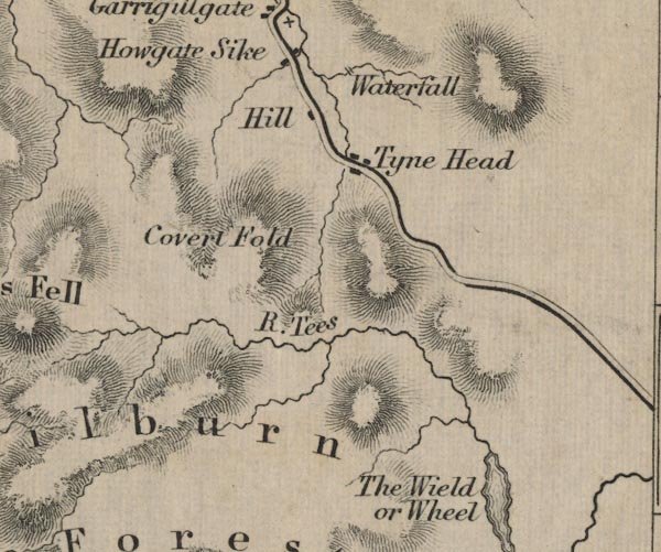 FD02NY73.jpg "The Wield or Wheel" Outline with form lines / hill hachuring ? item:- JandMN : 100.1 Image © see bottom of page |
|
|
|
||
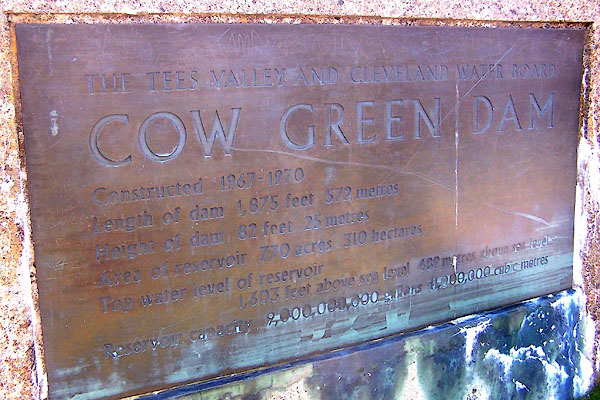 BQS25.jpg Plaque:- "THE TEES VALLEY AND CLEVELAND WATER BOARD / COW GREEN DAM / Constructed 1967-1970 / Length of dam 1,875 feet 572 metres / Height of dam 82 feet 25 metres / Area of reservoir 770 acres 310 hectares / Top water level of reservoir 1,603 feet above sea level 489 metres above sea level / Reservoir capacity 2,000,000,000 gallons 41,000,000 cubic metres" (taken 1.6.2009) 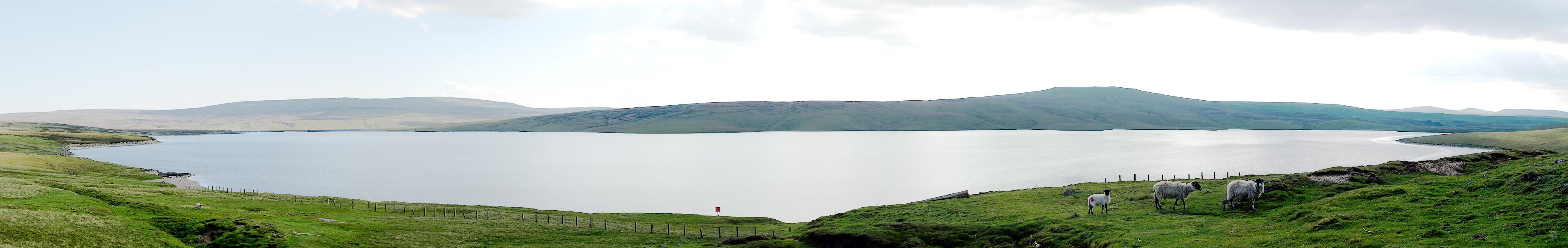 Click to enlarge BQS28.jpg (taken 1.6.2009) |
||
|
|
||
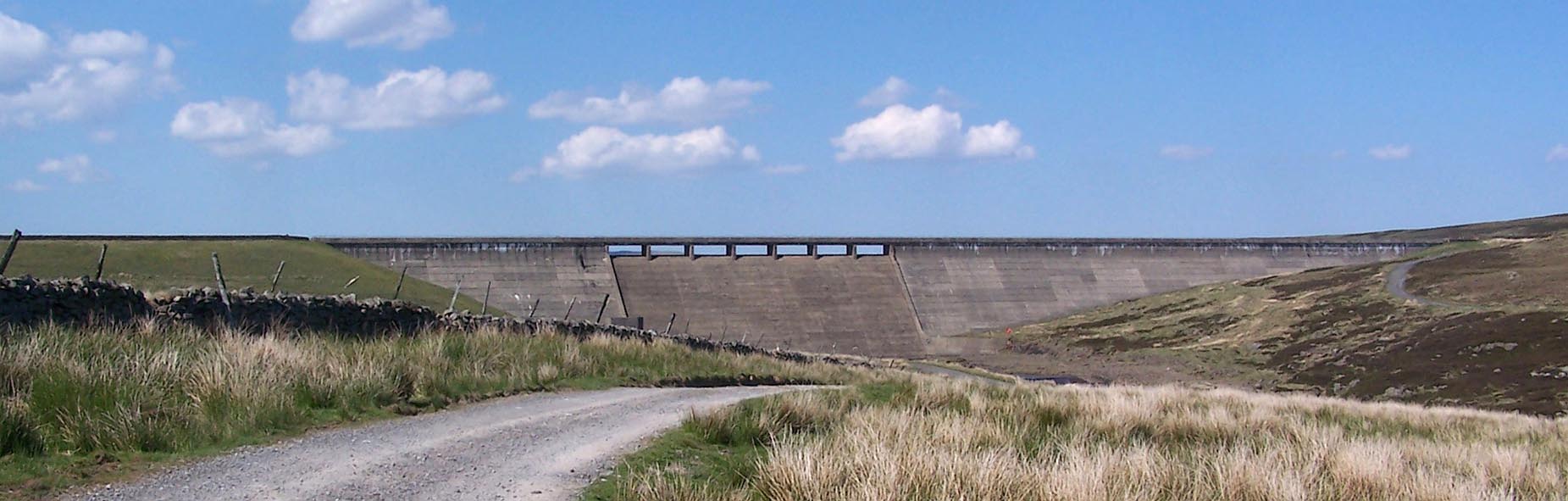 Click to enlarge BQS20.jpg The dam, (taken 1.6.2009) 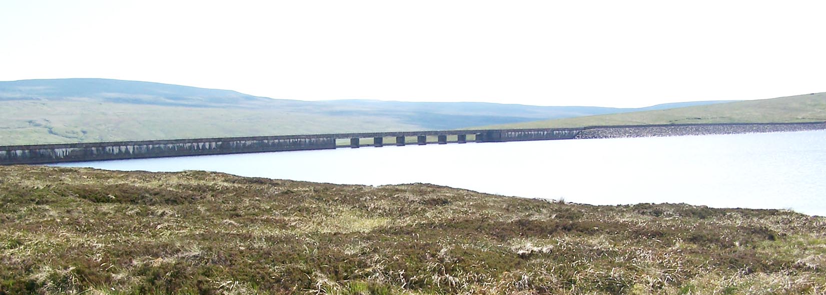 Click to enlarge BQS26.jpg The dam, (taken 1.6.2009) 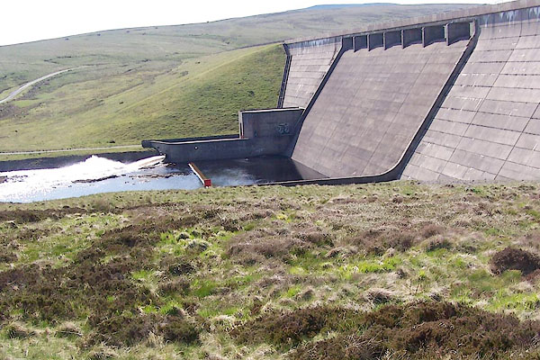 BQS21.jpg The dam, (taken 1.6.2009) 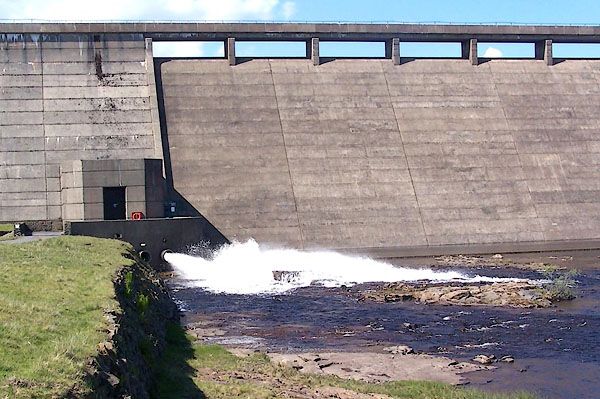 BQS22.jpg The dam, (taken 1.6.2009)  BQS23.jpg The dam, (taken 1.6.2009) |
||
|
|
||
 Lakes Guides menu.