 Old Cumbria Gazetteer
 |
 |
|
| Whinfell Forest, Brougham | ||
| Whinfell Forest | ||
| site name:- | Whinfell Park | |
| civil parish:- | Brougham (formerly Westmorland) | |
| county:- | Cumbria | |
| locality type:- | forest | |
| locality type:- | wood | |
| coordinates:- | NY57372715 (etc) | |
| 1Km square:- | NY5727 | |
| 10Km square:- | NY52 | |
|
|
||
| evidence:- | old map:- OS County Series (Wmd 4 14) placename:- Whinfell Forest |
|
| source data:- | Maps, County Series maps of Great Britain, scales 6 and 25
inches to 1 mile, published by the Ordnance Survey, Southampton,
Hampshire, from about 1863 to 1948. OS County Series (Wmd 4 15) |
|
|
|
||
| evidence:- | old map:- Saxton 1579 placename:- Whinfeld Forest |
|
| source data:- | Map, hand coloured engraving, Westmorlandiae et Cumberlandiae Comitatus ie Westmorland
and Cumberland, scale about 5 miles to 1 inch, by Christopher Saxton, London, engraved
by Augustinus Ryther, 1576, published 1579-1645.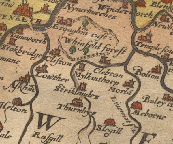 Sax9NY52.jpg "Whinfeld forest" Trees in the park. item:- private collection : 2 Image © see bottom of page |
|
|
|
||
| evidence:- | old map:- Speed 1611 (Cmd) placename:- Whinfeld Forest |
|
| source data:- | Map, hand coloured engraving, Cumberland and the Ancient Citie
Carlile Described, scale about 4 miles to 1 inch, by John Speed,
1610, published by J Sudbury and George Humble, Popes Head
Alley, London, 1611-12.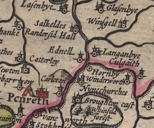 SP11NY53.jpg "Whinfeld forest" tree symbols; Westmorland item:- private collection : 16 Image © see bottom of page |
|
|
|
||
| evidence:- | old map:- Speed 1611 (Wmd) placename:- Whinfeld Forest |
|
| source data:- | Map, hand coloured engraving, The Countie Westmorland and
Kendale the Cheif Towne, scale about 2.5 miles to 1 inch, by
John Speed, 1610, published by George Humble, Popes Head Alley,
London, 1611-12.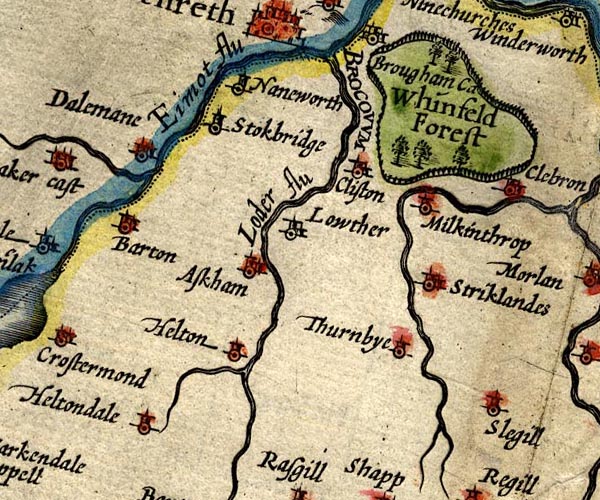 SP14NY52.jpg "Whinfeld Forest" circle of fence palings, trees item:- Armitt Library : 2008.14.5 Image © see bottom of page |
|
|
|
||
| evidence:- | poem:- Drayton 1612/1622 text placename:- Winfield Forest |
|
| source data:- | Poem, Poly Olbion, by Michael Drayton, published by published by
John Marriott, John Grismand and Thomas Dewe, and others?
London, part 1 1612, part 2 1622. goto source goto sourcepage 163:- "... ... as Westmerland shee [Eden] leaves, Where Cumberland againe as kindly her receives. Yet up her watry hands, to Winfield Forrest holds In her rough wooddy armes, which amorously infolds Cleere Eden comming by, with all her watry store, In her dark shades, and seemes her parting to deplore." |
|
|
|
||
| evidence:- | old map:- Drayton 1612/1622 placename:- Whinfeeld Forest |
|
| source data:- | Map, hand coloured engraving, Cumberlande and Westmorlande, by
Michael Drayton, probably engraved by William Hole, scale about
4 or 5 miles to 1 inch, published by John Mariott, John
Grismand, and Thomas Dewe, London, 1622.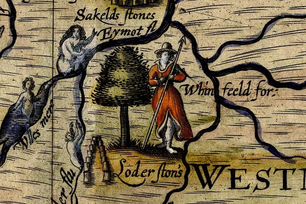 DRY511.jpg "Whinfeeld for:" Tree, huntress with a spear. item:- JandMN : 168 Image © see bottom of page |
|
|
|
||
| evidence:- | old map:- Jansson 1646 placename:- Whinfeld Forest |
|
| source data:- | Map, hand coloured engraving, Cumbria and Westmoria, ie
Cumberland and Westmorland, scale about 3.5 miles to 1 inch, by
John Jansson, Amsterdam, Netherlands, 1646.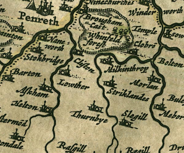 JAN3NY52.jpg "Whinfeld forest" Group of tree symbols within a ring of fence palings. item:- JandMN : 88 Image © see bottom of page |
|
|
|
||
| evidence:- | hearth tax returns:- Hearth Tax 1675 placename:- Whinfield and woodside |
|
| source data:- | Records, hearth tax survey returns, Westmorland, 1674/75. "Whinfield and woodside" |
|
|
|
||
| evidence:- | hearth tax returns:- Hearth Tax 1670 placename:- Whinfeild Forrest |
|
| source data:- | Records, hearth tax returns, exchequer duplicates, Westmorland,
1670. "Whinfeild Forrest" |
|
|
|
||
| evidence:- | old map:- Morden 1695 (Cmd) placename:- Whinfeld Forest |
|
| source data:- | Map, uncoloured engraving, Cumberland, scale about 4 miles to 1
inch, by Robert Morden, 1695, published by Abel Swale, the
Unicorn, St Paul's Churchyard, Awnsham, and John Churchill, the
Black Swan, Paternoster Row, London, 1695-1715.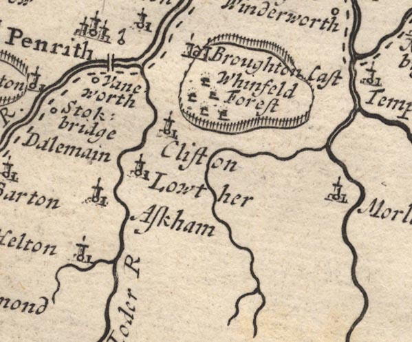 MD12NY52.jpg "Whinfeld Forest" Trees in the park. item:- JandMN : 90 Image © see bottom of page |
|
|
|
||
| evidence:- | old map:- Morden 1695 (Wmd) placename:- Whinfeild Forrest |
|
| source data:- | Map, hand coloured engraving, Westmorland, scale about 2.5 miles to 1 inch, by Robert
Morden, published by Abel Swale, the Unicorn, St Paul's Churchyard, Awnsham, and John
Churchill, the Black Swan, Paternoster Row, London, 1695.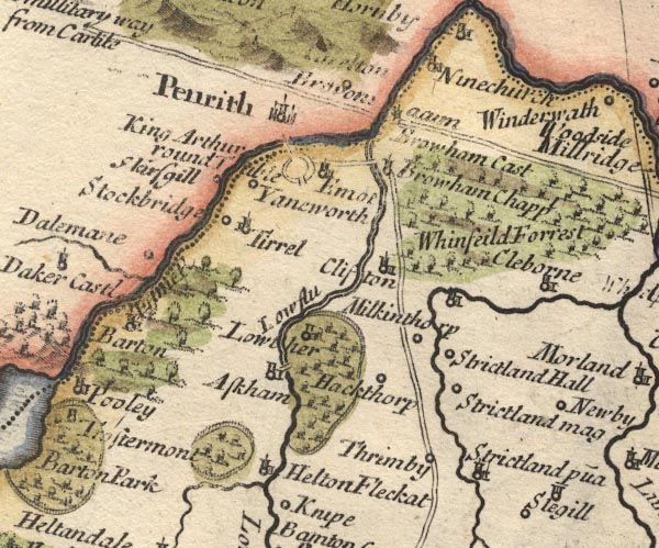 MD10NY52.jpg "Whinfeild Forrest" Trees. item:- JandMN : 24 Image © see bottom of page |
|
|
|
||
| evidence:- | descriptive text:- Simpson 1746 placename:- Whinfield Forest |
|
| source data:- | Atlas, three volumes of maps and descriptive text published as
'The Agreeable Historian, or the Compleat English Traveller
...', by Samuel Simpson, 1746. goto source Page 1021:- "..." "... there are divers Forests in the Barony of Westmoreland, as Whinfield-Forest in the Peninsula between the Rivers Eimot and Eden; ..." |
|
|
|
||
| evidence:- | old map:- Simpson 1746 map (Wmd) placename:- Wingfield Forrest |
|
| source data:- | Map, uncoloured engraving, Westmorland, scale about 8 miles to 1
inch, printed by R Walker, Fleet Lane, London, 1746.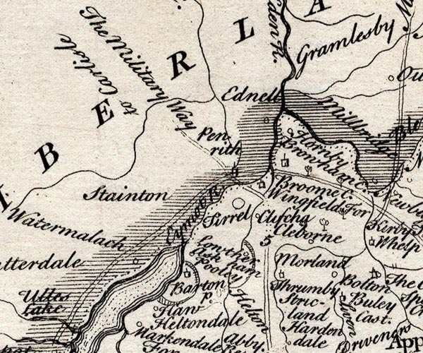 SMP2NYL.jpg "Wingfield For" Tree symbols, just a couple. item:- Dove Cottage : 2007.38.59 Image © see bottom of page |
|
|
|
||
| evidence:- | old text:- Morgan 1759 placename:- Whinfield Park |
|
| source data:- | MG02q054.txt "Whinfield-park, is an extensive forest, the property of the Earl of Thanet. Here is a large track of ground, lately enclosed from the park, on which corn now grows. Nothing can give greater pleasure to the eye of the traveller, than to behold cultivation and industry stretching forth their paces over the heath and waste, the forest and the chase." |
|
|
|
||
| evidence:- | old map:- Bowen and Kitchin 1760 placename:- Wingfield Forest |
|
| source data:- | Map, hand coloured engraving, A New Map of the Counties of
Cumberland and Westmoreland Divided into their Respective Wards,
scale about 4 miles to 1 inch, by Emanuel Bowen and Thomas
Kitchin et al, published by T Bowles, Robert Sayer, and John
Bowles, London, 1760.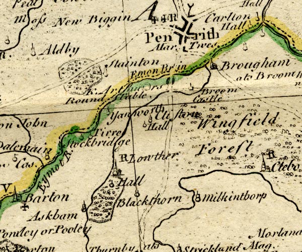 BO18NY42.jpg "Wingfield Forest" trees item:- Armitt Library : 2008.14.10 Image © see bottom of page |
|
|
|
||
| evidence:- | old map:- Jefferys 1770 (Wmd) placename:- Whinfell Forest |
|
| source data:- | Map, 4 sheets, The County of Westmoreland, scale 1 inch to 1
mile, surveyed 1768, and engraved and published by Thomas
Jefferys, London, 1770.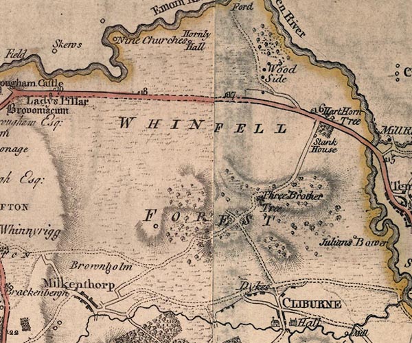 J5NY52NE.jpg "WHINFELL FOREST" area item:- National Library of Scotland : EME.s.47 Image © National Library of Scotland |
|
|
|
||
| evidence:- | old map:- Cary 1789 (edn 1805) placename:- Whinfell Forest |
|
| source data:- | Map, uncoloured engraving, Westmoreland, scale about 2.5 miles
to 1 inch, by John Cary, London, 1789; edition 1805.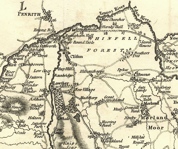 CY24NY52.jpg "WHINFELL FOREST" area item:- JandMN : 129 Image © see bottom of page |
|
|
|
||
| evidence:- | old text:- Gents Mag item:- oak |
|
| source data:- | Magazine, The Gentleman's Magazine or Monthly Intelligencer or
Historical Chronicle, published by Edward Cave under the
pseudonym Sylvanus Urban, and by other publishers, London,
monthly from 1731 to 1922. goto source Gentleman's Magazine 1825 part 1 p.516 "Compendium of County History. - Westmorland." "... WHINFELL, ... The forest was famous for its prodigious oaks, one of them nearly 300 years old. ..." |
|
|
|
||
| evidence:- | old text:- Gents Mag |
|
| source data:- | Magazine, The Gentleman's Magazine or Monthly Intelligencer or
Historical Chronicle, published by Edward Cave under the
pseudonym Sylvanus Urban, and by other publishers, London,
monthly from 1731 to 1922. goto source Gentleman's Magazine 1849 part 2 p.138 "..." "... About the same period [1760s], also, the memorable Westmerland forest of Whinfell - the ground of so much legendary story, which had seen the huntings of a Baliol and a Clifford, and beheld the enamoured Clifford of a later generation, with a faithful and life-long love, devoting himself to that peerless mistress whose memory is preserved by the lone farmstead that occupies the site of his fair "Julian's Bower" - was stripped of its stately trees and consigned to its present unsheltered state. Where are the long green shady lanes, with their many windings and hawthorn-scented hedges, rich with wild roses and fragrant honeysuckle, tall hazels, and glistening hollies, and the creeping ivy, which, hanging from tree to tree in graceful wreaths, screened the passer-by from each rude blast? Where the moss-covered dwellings, with their picturesque porches, low mullioned windows, and buttressed chimneys of the stalwart and independent statesmen? ..." |
|
|
|
||
| evidence:- | old map:- Garnett 1850s-60s H placename:- Whinfell Forest |
|
| source data:- | Map of the English Lakes, in Cumberland, Westmorland and
Lancashire, scale about 3.5 miles to 1 inch, published by John
Garnett, Windermere, Westmorland, 1850s-60s.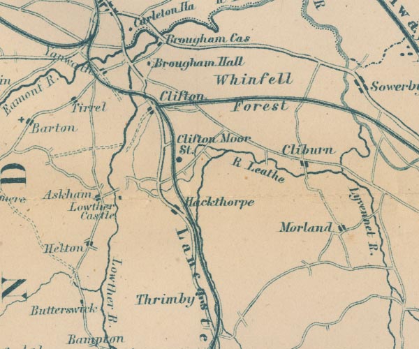 GAR2NY52.jpg "Whinfell Forest" area item:- JandMN : 82.1 Image © see bottom of page |
|
|
|
||
| evidence:- | old print:- Lowther 1780s-90s |
|
| source data:- | Print, engraving, North West Prospect of Whinfield Forest, ie Whinfell Forest, Brougham,
Cumbria, drawn by O Neale, engraved by Pranker, published by H Turpin, 104 St John
Street, Smithfield, London, 1779.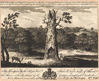 click to enlarge click to enlargeBNF08.jpg The central object is the Three Brother Tree. item:- Dove Cottage : Lowther.21 Image © see bottom of page |
|
|
|
||
Lakes Guides menu.