 Old Cumbria Gazetteer
 |
 |
|
| Wasdale, Nether Wasdale | ||
| Wasdale | ||
| civil parish:- | Nether Wasdale (formerly Cumberland) | |
| county:- | Cumbria | |
| locality type:- | valley | |
| coordinates:- | NY17050668 (etc etc) | |
| 1Km square:- | NY1706 | |
| 10Km square:- | NY10 | |
|
|
||
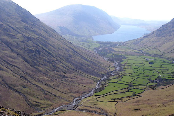 BNM85.jpg (taken 4.4.2007) 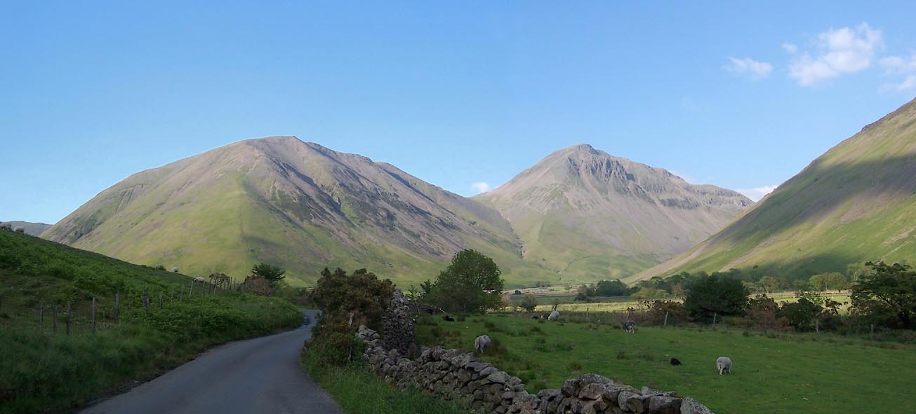 Click to enlarge BUR31.jpg (taken 3.6.2011) |
||
|
|
||
| evidence:- | poem:- Drayton 1612/1622 text placename:- Wasdale |
|
| source data:- | Poem, Poly Olbion, by Michael Drayton, published by published by
John Marriott, John Grismand and Thomas Dewe, and others?
London, part 1 1612, part 2 1622. goto source goto sourcepage 164:- "... With Wasdale walled in, with Hils on every side, ..." |
|
|
|
||
| evidence:- | old map:- Drayton 1612/1622 placename:- Wasedale |
|
| source data:- | Map, hand coloured engraving, Cumberlande and Westmorlande, by
Michael Drayton, probably engraved by William Hole, scale about
4 or 5 miles to 1 inch, published by John Mariott, John
Grismand, and Thomas Dewe, London, 1622.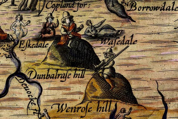 DRY520.jpg "Wasedale" Lady reclining. item:- JandMN : 168 Image © see bottom of page |
|
|
|
||
| evidence:- | old map:- Gents Mag 1751 placename:- Warsdale |
|
| source data:- | Map, uncoloured engraving, Map of the Black Lead Mines in
Cumberland, and area, scale about 2 miles to 1 inch, by George
Smith, published in the Gentleman's Magazine, 1751.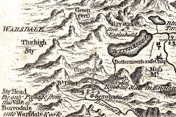 GM1305.jpg "WARSDALE" area item:- JandMN : 114 Image © see bottom of page |
|
|
|
||
| evidence:- | unlikely descriptive text:- West 1778 (11th edn 1821) placename:- Wastdale |
|
| source data:- | Guide book, A Guide to the Lakes, by Thomas West, published by
William Pennington, Kendal, Cumbria once Westmorland, and in
London, 1778 to 1821. goto source Account of Ennerdale, late 18th century Page 293:- "..." "... As he approaches the vale of Ennerdale, ... he will find the rugged scenery of the country gradually refining; and as he winds round the foot of the Pillar, he will discover a vista, which cannot fail to strike the most indifferent observer with astonishment and pleasure." "The mountains which serve to heighten this scene, and enhance its surprise, are Sty-head, Honister-crag, Wastdale, the Pillar, and Red-pike. ..." |
|
|
|
||
| evidence:- | old text:- Green 1810 placename:- Wastdale |
|
| source data:- | Set of prints, soft ground etchings, Sixty Studies from Nature,
by William Green, Ambleside, Westmorland, drawn 1808-10,
published 1810. goto source page 96:- "..." "The account here given of Wastdale" goto sourcepage 98:- "is more at large than was intended by the writer, the subject having grown upon him in attempting to give some account of the lake, and of the roads to and from it. Pedestrians of good bodily strength and spirits, will generally be gratified by their tour, and they will occasionally deviate from the beaten roads; even three or four ladies, with a guardian, a guide, and a couple of horses, might occasionally walk and ride, and make such a gipsying extremely pleasant; the retrospect of such an excursion over stubborn rocks and wild mountains, furnishing pretty conversation for the winter's drawing-room." |
|
|
|
||
| evidence:- | old text:- Green 1812 placename:- Wast Water |
|
| source data:- | Exhibition catalogue, The Eleventh Exhibition, drawings and
prints, Westmorland, Cumberland and Lancashire, by William
Green, Ambleside, Westmorland, 1812. goto source page 12:- "The year I arrived here [Ambleside] I made a number of pencil drawings, and surveyed with much attention this store-house of my future labours; - I had never seen Wast Water, and made an excursion to that romantic region, with a friend, in the November of that year; but though the mountain tops were hid in clouds, the scene exhibited a vastness and grandeur, highly gratifying to the feeling mind; we waited some time in expectation of seeing more, but our wish was not gratified, and we returned for that night to Eskdale, not without a mixed feeling of pleasure and disappointment: since that time I have often visited Wastdale, and seen it under many desirable circumstances of effect." "In 1801, with excessive labour and anxiety of mind, I travelled this extensive cluster of mountains in almost every possible variety of direction, and collected in pencil many hundred outlines from which a selection was made and finished drawings were produced from that selection, for the purpose of forming my first exhibition, which was opened in the middle of the summer, 1802." |
|
|
|
||
| evidence:- | descriptive text:- Otley 1823 (5th edn 1834) item:- geology |
|
| source data:- | Guide book, A Concise Description of the English Lakes, the
mountains in their vicinity, and the roads by which they may be
visited, with remarks on the mineralogy and geology of the
district, by Jonathan Otley, published by the author, Keswick,
Cumberland now Cumbria, by J Richardson, London, and by Arthur
Foster, Kirkby Lonsdale, Cumbria, 1823; published 1823-49,
latterly as the Descriptive Guide to the English Lakes. goto source Page 155:- "The SECOND division [of slate rocks] comprehends the mountains of Eskdale, Wasdale, Ennerdale, Borrowdale, Langdale, Grasmere, Patterdale, Martindale, Mardale, and some adjacent places; including the two highest mountains of the district, Scawfell and Helvellyn, as well as the Old Man at Coniston. All our fine towering crags belong to it; and most of the cascades among the lakes fall over it. There are indeed some lofty precipices in the former division; ..." "..." |
|
|
|
||
| evidence:- | old map:- Garnett 1850s-60s H placename:- Wasdale |
|
| source data:- | Map of the English Lakes, in Cumberland, Westmorland and
Lancashire, scale about 3.5 miles to 1 inch, published by John
Garnett, Windermere, Westmorland, 1850s-60s.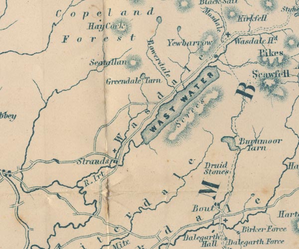 GAR2NY10.jpg "Wasdale" area item:- JandMN : 82.1 Image © see bottom of page |
|
|
|
||
| evidence:- | old text:- Martineau 1855 |
|
| source data:- | Guide book, A Complete Guide to the English Lakes, by Harriet
Martineau, published by John Garnett, Windermere, Westmorland,
and by Whittaker and Co, London, 1855; published 1855-76. goto source Page 113:- "[approaching Strands] ... when the circle of mountains round Wast Water opens before him. The lake is not visible; but there is no mistaking where it lies. To" goto sourcePage 114:- "the right, and close at hand, the Screes present their remarkable sweep of débris, and crests streaked with red, grey, and vivid green, and here and there cloven for the passage of cataracts from the brow, which tumble down through the gloom of woods. Hawlghyll is the largest of these ravines. Next, the Scawfell peaks rise above the rest; and Great End just peeps over the shoulder of Lingmell. The cleft between Lingmell and Great Gable is Sty Head Pass; and to the left, from Great Gable, are Yewbarrow and Middlefell. The broken foreground on the common whence this view is seen adds greatly to its beauty. Descending upon Wastdale, the Irt is crossed; and then the road meets others on the green. ..." "..." goto sourcePage 119:- "... The road winds pleasantly round bays and over promontories, and the pyramidal Yewbarrow, Great Gable, which closes in the dale, and Lingmell and the Scawfell Pikes to the right, all explain themselves. Several brooks and rills are passed, flowing down from the valleys; and the stranger exclaims that he should like to spend a whole summer here, to explore all the ways among the mountains. ... The opening out of the dale head, when the valley has appeared to close in round the lake, is as wonderful a spectacle to strangers as any thing they see. The dale is one of those perfect levels, shut in by lake and mountains, which give a different impression from any other kind of scenery in the world. The passes themselves are so high as to leave no appearance of outlet, except by the" goto sourcePage 120:- "lake; and of these passes there are but two,- the Sty Head and Mosedale paths. The green and perfect level, to which the mountains come down with a sheer sweep, is partly divided off into fields; and a few farm-houses are set down among the fields, on the bends of the gushing and gurgling stream. There is a chapel,... There is now a school:- a chapel and a school and no public house! ... It struck us that the children were dirtier than even in other vales, though the houses are so clean that you might eat your dinner off the board or the floor. But the state of children's skin and hair is owing to superstition, in all these dales; and the schoolmaster is the one who should cure the evil. A young lady who kindly undertook to wash and dress the infant of a sick woman, but who was not experienced in the process, exclaimed at the end "0 dear! I forgot it's hands and arms. I must wash them." The mother expressed great horror, and said that "if the child's arms were washed before it was six months old, it would be a thief;" and, added she, pathetically, "I would not like that." The hair and nails must not be cut for a much longer time, for fear of a like result." goto sourcePage :- "The Yorkshire people put the alternative of dirty and clean rather strongly in their proverb, "Better hev a bairn wi a mucky feace than wash its noase off:" but the Cumberland folk view the matter more in a moral way, and refuse to have their children baptised into thievery." "... Wastdale Head is the place whence the ascent of Scawfell should be made: but we must defer that; ..." |
|
|
|
||
 Will Ritson of Wasdale Head Will Ritson of Wasdale Head |
||
|
|
||
| evidence:- | old print:- |
|
| source data:- | Print, Bridge at Wasdale, Cumberland, drawn and engraved by William Green, Ambleside,
Westmorland, 1809. click to enlarge click to enlargePR1262.jpg A single span stone bridge spans a shallow rocky stream either bank of which is fringed with trees. Distant fells rise beyond. printed at bottom centre:- "BRIDGE IN WASDALE. Published Ambleside. Augst 1st 1809 by W. Green." item:- Tullie House Museum : 1978.108.92.1 Image © Tullie House Museum |
|
|
|
||
 Click to enlarge BTE58.jpg (taken 13.7.2010) |
||
|
|
||
Lakes Guides menu.