 Old Cumbria Gazetteer
 |
 |
|
| included in:- |
 Bassenthwaite Lake Bassenthwaite Lake |
|
| viewpoint, Sandbeds Gill | ||
| site name:- | Sandbeds Gill | |
| civil parish:- | Bassenthwaite (formerly Cumberland) | |
| county:- | Cumbria | |
| locality type:- | viewpoint | |
| 1Km square:- | NY2329 | |
| 10Km square:- | NY22 | |
|
|
||
| evidence:- | old map:- Crosthwaite 1783-94 (Bas) placename:- station, Bassenthwaite, Crosthwaite 2 |
|
| source data:- | Map, uncoloured engraving, An Accurate Map of Broadwater or
Bassenthwaite Lake, scale about 3 inches to 1 mile, by Peter
Crosthwaite, Keswick, Cumberland, 1783, version published 1800.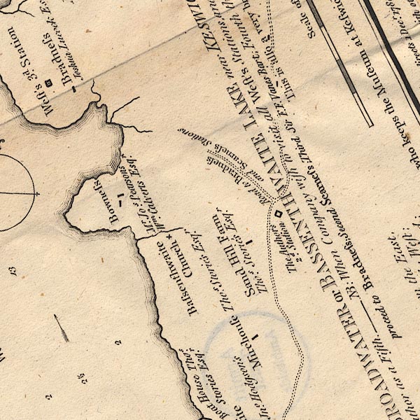 CT6NY22J.jpg "The Author's 2d. Station" Elsewhere on the map:- "N.B. In 1794, the Author pointed out two other Stations; ... the 2d. 1½ Mile to the Northwards of the first &may be known by the Bradness broad Lane, leading from the main Road to the Left." item:- Armitt Library : 1959.191.4 Image © see bottom of page |
|
|
|
||
| indexing | ||
| person:- | map maker : Crosthwaite, Peter |
|
| place:- | Bassenthwaite Lake | |
| date:- | 1785 |
|
| period:- | 18th century, late | |
| period:- | 1780s | |
| item:- | map; Accurate Map of Broadwater or Bassenthwaite Lake |
|
|
|
||
Lakes Guides menu.