 Old Cumbria Gazetteer
 |
 |
|
| included in:- |
 Windermere lake Windermere lake |
|
| viewpoint, Rawlinson Nab | ||
| site name:- | Rawlinson Nab | |
| civil parish:- | Claife (formerly Lancashire) | |
| county:- | Cumbria | |
| locality type:- | viewpoint | |
| coordinates:- | SD38599305 (about) | |
| 1Km square:- | SD3893 | |
| 10Km square:- | SD39 | |
|
|
||
| evidence:- | descriptive text:- West 1778 (11th edn 1821) placename:- station, Windermere, West 4 |
|
| source data:- | Guide book, A Guide to the Lakes, by Thomas West, published by
William Pennington, Kendal, Cumbria once Westmorland, and in
London, 1778 to 1821. goto source Page 65:- "STATION IV. Rawlinson's-nab is a peninsular-rock, of a circular figure, swelling to a crown in the centre, covered with a low wood; there are two of them, but it is from the crown of the interior nab, you have the present surprising view of two fine sheets of water, that bend different ways." "The view to the south, is bounded on both sides by a bold and various shore. The hills are wooded and rough, but spotted in parts with small inclosures, and their tops burst into rocks of various shapes." goto sourcePage 66:- "The view to the north is more beautiful: an extent of three miles of the lake is broken into by the bold promontory, the Storrs, and above that, Berkshire-island is charmingly placed. Bannerigg and Orrest-head, rising inward from the shore in magnificent slopes, are seen from hence to great advantage. This beautiful scene is well contrasted on the opposite side, by a ridge of hanging woods, spread over wild romantic grounds, that shoot abruptly into bold and spirited projections [1]." "[1] As it commanded more of the mountains at the head of the lake, Mr. Farrington has given the view from Gillhead." goto sourcePage 70:- "..." "... These [stations, Windermere 4 and 5] are the finest stations on the lake for pleasing the eye, but are much too elevated for the purpose of the artist, ..." goto sourcePage 70:- "..." "Rawlinson's-nab is a picturesque point, either for the eye or for the pencil. You are there advanced a great way into the lake, in the midst of the finest scenes, and with a charming fore-ground. ..." |
|
|
|
||
| evidence:- | old map:- Crosthwaite 1783-94 (Win/Ble) |
|
| source data:- | Map, uncoloured engraving, An Accurate Map of the Grand Lake of
Windermere, scale about 2 inches to 1 mile, by Peter
Crosthwaite, Keswick, Cumberland, 1783, version published 1819.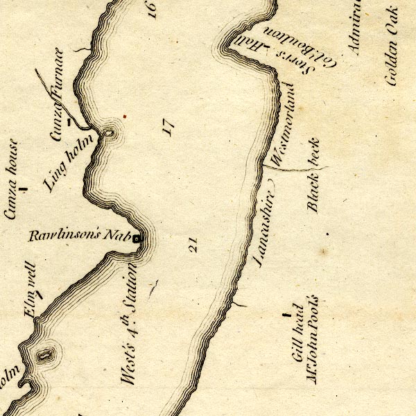 CT9SD39W.jpg "West's 4th. Station" square symbol, on Rawlinson's Nab item:- Armitt Library : 2008.14.102 Image © see bottom of page |
|
|
|
||
| evidence:- | old map:- Crosthwaite 1783-94 (Win/Ble) placename:- station, Windermere, West 4 |
|
| source data:- | Series of maps, An Accurate Map of the Matchless Lake of
Derwent, of the Grand Lake of Windermere, of the Beautiful Lake
of Ullswater, of Broadwater or Bassenthwaite Lake, of Coniston
Lake, of Buttermere, Crummock and Loweswater Lakes, and
Pocklington's Island, by Peter Crosthwaite, Kendal, Cumberland
now Cumbria, 1783 to 1794. marked on the map of lake Windermere, on the end of Rawlinson's Nab "West's 4th. Station" |
|
|
|
||
| indexing | ||
| person:- | author : West, Thomas |
|
| place:- | Windermere lake | |
| date:- | 1778 |
|
| period:- | 18th century, late | |
| period:- | 1780s | |
| item:- | guide book; Guide to the Lakes |
|
|
|
||
Lakes Guides menu.