 Old Cumbria Gazetteer
 |
 |
|
| Solway Moss, Kirkandrews | ||
| Solway Moss | ||
| locality:- | Debatable Land | |
| civil parish:- | Kirkandrews (formerly Cumberland) | |
| county:- | Cumbria | |
| locality type:- | moss | |
| locality type:- | peat moss | |
| coordinates:- | NY34366926 (etc) | |
| 1Km square:- | NY3469 | |
| 10Km square:- | NY36 | |
|
|
||
| evidence:- | old map:- OS County Series (Cmd 10 1) placename:- Solway Moss |
|
| source data:- | Maps, County Series maps of Great Britain, scales 6 and 25
inches to 1 mile, published by the Ordnance Survey, Southampton,
Hampshire, from about 1863 to 1948. "SOLWAY MOSS / (Site of Battle 1543)" |
|
|
|
||
| evidence:- | old map:- Saxton 1579 placename:- Sollome Moss |
|
| source data:- | Map, hand coloured engraving, Westmorlandiae et Cumberlandiae Comitatus ie Westmorland
and Cumberland, scale about 5 miles to 1 inch, by Christopher Saxton, London, engraved
by Augustinus Ryther, 1576, published 1579-1645.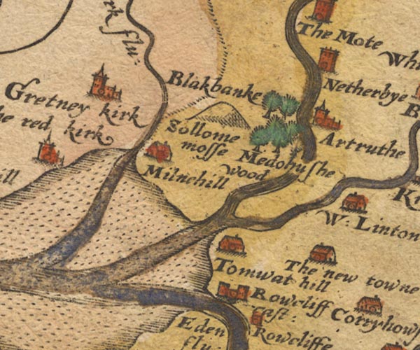 Sax9NY36.jpg "Sollome moss" item:- private collection : 2 Image © see bottom of page |
|
|
|
||
| evidence:- | old map:- Burghley 1590 (facsimile) placename:- Sollomos |
|
| source data:- | Facsimile map, A Platt of the Opposete Border of Scotland to ye West Marches of England,
parts of Cumberland and Scotland including the Debateable Land, from a manuscript
drawn for William Cecil, Lord Burghley, about 1590, published by R B Armstrong, 1897. courtesy of the National Library of Scotland 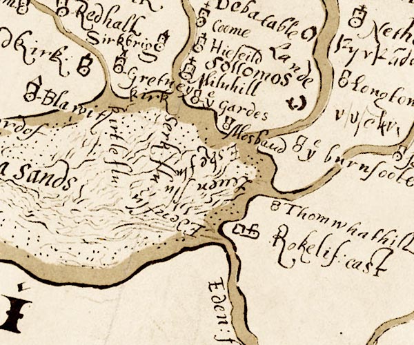 M048NY36.jpg "Sollomos" item:- National Library of Scotland : MS6113 f.267 Image © National Library of Scotland |
|
|
|
||
| evidence:- | old map:- Speed 1611 (Cmd) placename:- Sollome Moss |
|
| source data:- | Map, hand coloured engraving, Cumberland and the Ancient Citie
Carlile Described, scale about 4 miles to 1 inch, by John Speed,
1610, published by J Sudbury and George Humble, Popes Head
Alley, London, 1611-12.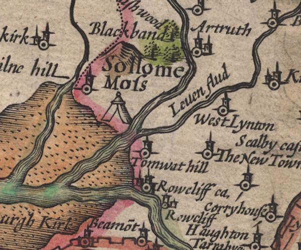 SP11NY36.jpg "Sollome Moss" area item:- private collection : 16 Image © see bottom of page |
|
|
|
||
| evidence:- | old map:- Jansson 1646 placename:- Sollome Moss |
|
| source data:- | Map, hand coloured engraving, Cumbria and Westmoria, ie
Cumberland and Westmorland, scale about 3.5 miles to 1 inch, by
John Jansson, Amsterdam, Netherlands, 1646.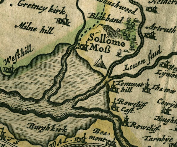 JAN3NY36.jpg "Sollome Moss" No symbol; the label may apply to the tent symbol ie the Battle of Solway Moss. item:- JandMN : 88 Image © see bottom of page |
|
|
|
||
| evidence:- | old map:- Seller 1694 (Cmd) placename:- Sollome Moss |
|
| source data:- | Map, uncoloured engraving, Cumberland, scale about 12 miles to 1
inch, by John Seller, 1694. click to enlarge click to enlargeSEL9.jpg "Sollome moss" area of marsh item:- Dove Cottage : 2007.38.89 Image © see bottom of page |
|
|
|
||
| evidence:- | old map:- Morden 1695 (Cmd) placename:- Sollome Mosse |
|
| source data:- | Map, uncoloured engraving, Cumberland, scale about 4 miles to 1
inch, by Robert Morden, 1695, published by Abel Swale, the
Unicorn, St Paul's Churchyard, Awnsham, and John Churchill, the
Black Swan, Paternoster Row, London, 1695-1715.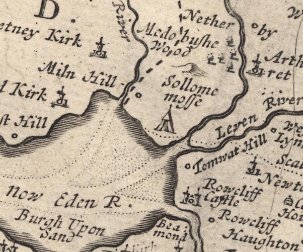 MD12NY36.jpg "Sollome mosse" Labelling a tent symbol for a battle site or the moss itself. item:- JandMN : 90 Image © see bottom of page |
|
|
|
||
| evidence:- | old map:- Bowen and Kitchin 1760 placename:- Sollome Moss |
|
| source data:- | Map, hand coloured engraving, A New Map of the Counties of
Cumberland and Westmoreland Divided into their Respective Wards,
scale about 4 miles to 1 inch, by Emanuel Bowen and Thomas
Kitchin et al, published by T Bowles, Robert Sayer, and John
Bowles, London, 1760.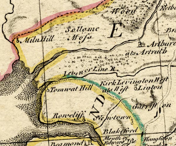 BO18NY36.jpg "Sollome Moss" tussocks item:- Armitt Library : 2008.14.10 Image © see bottom of page |
|
|
|
||
| evidence:- | old map:- Donald 1774 (Cmd) placename:- Solway Moss |
|
| source data:- | Map, hand coloured engraving, 3x2 sheets, The County of Cumberland, scale about 1
inch to 1 mile, by Thomas Donald, engraved and published by Joseph Hodskinson, 29
Arundel Street, Strand, London, 1774. D4NY36NW.jpg  D4NY36NE.jpg "Solway Moss" moss item:- Carlisle Library : Map 2 Images © Carlisle Library |
|
|
|
||
| evidence:- | old text:- Camden 1789 placename:- Sollom Mosse |
|
| source data:- | Book, Britannia, or A Chorographical Description of the Flourishing Kingdoms of England,
Scotland, and Ireland, by William Camden, 1586, translated from the 1607 Latin edition
by Richard Gough, published London, 1789. goto source goto sourcePage 176:- "..." "... Beyond this river Esk the country for some miles is accounted part of England, in which is Sollom-mosse, ..." |
|
|
|
||
| evidence:- | old text:- Camden 1789 (Gough Additions) placename:- Solom Moss item:- placename, Solway Moss; peat digging; eruption; Solway Flow |
|
| source data:- | Book, Britannia, or A Chorographical Description of the Flourishing Kingdoms of England,
Scotland, and Ireland, by William Camden, 1586, translated from the 1607 Latin edition
by Richard Gough, published London, 1789. goto source Page 188:- "..." "... Within it [Arthuret] lies a noted morass, commonly called Solom moss, from a small village of that name on the Scotch side. ..." "Solom or Solway Moss consists of 1600 acres, raised a little above the cultivated tract, a mass of thin peaty mud, with a crust too weak in the driest summer to bear a man's weight. In December 1769 it burst its banks by the excessive winter rains of three days continuance preceeding, and the too near approaches of the peat diggers, which had weakened the crust at a gap about 50 yards wide. About 300 acres of moss discharged themselves in a black stream charged with large masses of peat, which surrounded the cottages, and covered 400 acres of cultivated land. Many cattle were drowned, but not one human life lost. It filled the whole valley, leaving behind it great heaps of turf from 3 to 15 and 30 feet, memorials of its height, and at last reached and fell into the Esk. The surface of the moss was reduced near 25 feet sunk into a hollow form." "In that part called Solway Flow, in the year 1771, was a memorable out-burst of water, moss, gravel, sand, and stones, which spread over and destroyed about 600 acres of fine level fertile ground, and totally altered the face of that part of the country. The moss had been observed to have risen imperceptibly for a long time before. It began to move in the night of November 16, and continued in movement for three days slowly forward, so that the inhabitants generally had time to get off their cattle and other moveables before their houses were burried or rendered inaccessible. The mouth of the breach was about 20 yards wide, and when it began to flow was in depth between five and six yards. By this eruption 28 families were driven from their habitations, and their grounds rendered totally useless and seemed irrecoverable by reason of the depth of covering of the morass and other rubbish to the depth of at least 15 feet. but by means of hushing upwards of 100 acres have been cleared; and, by the indefatigable industry of the owner, it is thought the whole will be recovered, though it will be attended with great expence. Out of the aforesaid moss, Dr. Todd says, have frequently been dug human bones, silver coins of the later ages, earthen pots, iron, and brass weapons, with oak and fir trees of unusual magnitude." |
|
|
|
||
| evidence:- | old text:- Harper 1907 placename:- Solway Moss item:- Liber Studiorum |
|
| source data:- | HP01p157.txt Page 157:- "..." "Solway Moss is passed on the way. Turner has made it the subject of one of the finest plates in his Liber Studiorum, and has imported into the view some mountains that are not there, together with some weather which, fortunately for the present writer, was equally absent when he passed this way." "..." HP01p158.txt Page 158:- "..." 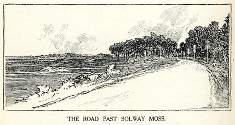 click to enlarge click to enlargeHP0127.jpg "THE ROAD PAST SOLWAY MOSS." "Turner therefore does right in so romantically treating the subject, and I am merely a pictorial reporter, setting down only what I see. But at any rate, while Turner might dissuade the pilgrim, with his storm overhead and his fathomless bog beneath, whence apparently some wretches are just escaping with their lives, you see by the modern sketch that there is at least a hard high road running by." "In November, 1771, the Bog of Solway burst like a torrent, being charged with exceptionally heavy rains, and destroyed some thirty villages." "..." item:- JandMN : 1055.29 Image © see bottom of page |
|
|
|
||
| notes:- |
The moss is a raised bog, mud and vegtable matter, with a thin dry crust. |
|
|
|
||
Lakes Guides menu.