 Old Cumbria Gazetteer
 |
 |
|
||||||||||||||||||||||||||||||||||||||||||||||||||||
| Scafell Pike, Eskdale | ||||||||||||||||||||||||||||||||||||||||||||||||||||||
| Scafell Pike | ||||||||||||||||||||||||||||||||||||||||||||||||||||||
| civil parish:- | Eskdale (formerly Cumberland) | |||||||||||||||||||||||||||||||||||||||||||||||||||||
| county:- | Cumbria | |||||||||||||||||||||||||||||||||||||||||||||||||||||
| locality type:- | hill | |||||||||||||||||||||||||||||||||||||||||||||||||||||
| coordinates:- | NY21550722 | |||||||||||||||||||||||||||||||||||||||||||||||||||||
| 1Km square:- | NY2107 | |||||||||||||||||||||||||||||||||||||||||||||||||||||
| 10Km square:- | NY20 | |||||||||||||||||||||||||||||||||||||||||||||||||||||
| altitude:- | 3205 feet | |||||||||||||||||||||||||||||||||||||||||||||||||||||
| altitude:- | 977m | |||||||||||||||||||||||||||||||||||||||||||||||||||||
|
|
||||||||||||||||||||||||||||||||||||||||||||||||||||||
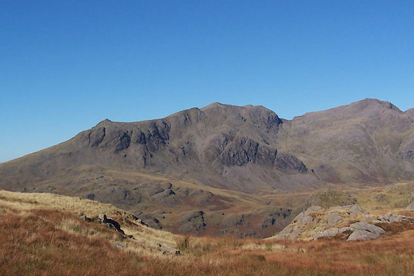 BTR12.jpg Slight Side, Sca Fell, Scafell Pikes, from Hard Knott (taken 11.10.2010) 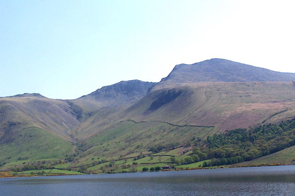 BMB38.jpg (taken 11.5.2006) |
||||||||||||||||||||||||||||||||||||||||||||||||||||||
|
|
||||||||||||||||||||||||||||||||||||||||||||||||||||||
| evidence:- | old map:- OS County Series (Cmd 74 16) placename:- Scafell Pikes |
|||||||||||||||||||||||||||||||||||||||||||||||||||||
| source data:- | Maps, County Series maps of Great Britain, scales 6 and 25
inches to 1 mile, published by the Ordnance Survey, Southampton,
Hampshire, from about 1863 to 1948. |
|||||||||||||||||||||||||||||||||||||||||||||||||||||
|
|
||||||||||||||||||||||||||||||||||||||||||||||||||||||
| evidence:- | descriptive text:- West 1778 (11th edn 1821) placename:- Scafell |
|||||||||||||||||||||||||||||||||||||||||||||||||||||
| source data:- | Guide book, A Guide to the Lakes, by Thomas West, published by
William Pennington, Kendal, Cumbria once Westmorland, and in
London, 1778 to 1821. goto source goto sourcePage 190:- "A TABLE OF THE Height of Mountains and Lakes SEEN IN THIS TOUR, ... TAKEN FROM THE LEVEL OF THE SEA. ... by Mr. John Dalton." "Scafell, north point E. of Wast-water ... 1080 [yards]" "..." "From this survey of mountains it appears that Scafell is the highest in England, yet below the point of permanent snow. ..." "... no mountain in England touches the zone of barrenness that intervenes between this region and the limits of vegetation." |
|||||||||||||||||||||||||||||||||||||||||||||||||||||
|
|
||||||||||||||||||||||||||||||||||||||||||||||||||||||
| evidence:- | old map:- Otley 1818 placename:- Pikes |
|||||||||||||||||||||||||||||||||||||||||||||||||||||
| source data:- | Map, uncoloured engraving, The District of the Lakes,
Cumberland, Westmorland, and Lancashire, scale about 4 miles to
1 inch, by Jonathan Otley, 1818, engraved by J and G Menzies,
Edinburgh, Scotland, published by Jonathan Otley, Keswick,
Cumberland, et al, 1833. OT02NY20.jpg "PIKES" item:- JandMN : 48.1 Image © see bottom of page |
|||||||||||||||||||||||||||||||||||||||||||||||||||||
|
|
||||||||||||||||||||||||||||||||||||||||||||||||||||||
| evidence:- | old print:- Fielding and Walton 1821 (plate 29) |
|||||||||||||||||||||||||||||||||||||||||||||||||||||
| source data:- | Print, coloured aquatint, Wast Water, Nether Wasdale, Cumberland, drawn by Theodore
H A Fielding, published by R Ackermann, 101 Strand, London, 1821.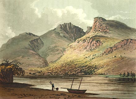 click to enlarge click to enlargeFW0129.jpg Scafell Pike, Mickledore, and Sca Fell in the background. Tipped in opposite p.196 in A Picturesque Tour of the English Lakes. item:- Dove Cottage : 1993.R566.29 Image © see bottom of page |
|||||||||||||||||||||||||||||||||||||||||||||||||||||
|
|
||||||||||||||||||||||||||||||||||||||||||||||||||||||
| evidence:- | outline view:- Otley 1823 (4th edn 1830) placename:- Scawfell Pike |
|||||||||||||||||||||||||||||||||||||||||||||||||||||
| source data:- | Print, engraving, outline view, Some of the Western Mountains as seen from Helvellyn,
published by Jonathan Otley, Keswick, Cumberland et al, 1830.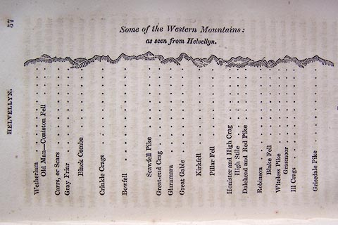 click to enlarge click to enlargeO75E02.jpg p.57 in A Concise Description of the English Lakes, by Jonathan Otley, 4th edition, 1830. "Some of the Western Mountains: / as seen from Helvellyn." "Wetherlam / Old Man - Coniston Fell / Carrs, or Scars / Gray Friar / Black Combe / Crinkle Crags / Bowfell / Scawfell Pike / Great-end Crag / Glaramara / Great Gable / Kirkfell / Pillar Fell / Honister and High Crag / High Stile / Dalehead and Red Pike / Robinson / Blake Fell / Witeless Pike / Grasmoor / Ill Crags / Grisedale Pike" item:- Armitt Library : A1175.3 Image © see bottom of page |
|||||||||||||||||||||||||||||||||||||||||||||||||||||
|
|
||||||||||||||||||||||||||||||||||||||||||||||||||||||
| evidence:- | outline view:- Otley 1823 (4th edn 1830) placename:- Scawfell Pike |
|||||||||||||||||||||||||||||||||||||||||||||||||||||
| source data:- | Print, engraving, outline view, Mountains of Coniston, Langdale, &c. as they appear
from the road between Troutbeck Bridge and Bowness, published by Jonathan Otley, Keswick,
Cumberland et al, 1830.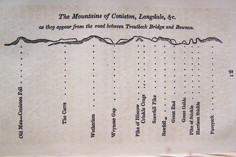 click to enlarge click to enlargeO75E04.jpg p.97 in A Concise Description of the English Lakes, by Jonathan Otley, 4th edition, 1830. "The Mountains of Coniston, Langdale, &c. / as they appear from the road between Troutbeck Bridge and Bowness." "Old Man - Coniston Fell / The Carrs / Wetherlam / Wrynose Gap / Pike of Bliscow / Crinkle Crags / Scawfell Pike / Bowfell / Great End / Great Gable / Pike of Stickle / Harrison Stickle / Paveyark" item:- Armitt Library : A1175.4 Image © see bottom of page |
|||||||||||||||||||||||||||||||||||||||||||||||||||||
|
|
||||||||||||||||||||||||||||||||||||||||||||||||||||||
| evidence:- | outline view:- Otley 1823 (4th edn 1830) placename:- Scawfell Pike |
|||||||||||||||||||||||||||||||||||||||||||||||||||||
| source data:- | Print, engraving, outline view, Mountains South West of Derwentwater as seen from
Keswick, published by Jonathan Otley, Keswick, Cumberland et al, 1830.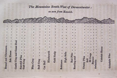 click to enlarge click to enlargeO75E06.jpg p.115 in A Concise Description of the English Lakes, by Jonathan Otley, 4th edition, 1830. "The Mountains South-West of Derwentwater: / as seen from Keswick." "Brund and Glaramara / Esk Hause / Castle Crag and Great End / Scawfell Pike / Gait Crag / Blea Crag / Bull Crag / Cat Bell / Hindscarth / Gold Scalp / Robinson / High Stile / Red Pike / Rawling end / Causey Pike / Sail / Ill Crags / Barrow / Swinside / Coledale Hause / Grisedale Pike" item:- Armitt Library : A1175.6 Image © see bottom of page |
|||||||||||||||||||||||||||||||||||||||||||||||||||||
|
|
||||||||||||||||||||||||||||||||||||||||||||||||||||||
| evidence:- | outline view:- Otley 1823 (4th edn 1830) placename:- Scawfell Pike |
|||||||||||||||||||||||||||||||||||||||||||||||||||||
| source data:- | Print, engraving, outline view, Mountains round Wastwater as seen from the Strands
in Nether Wasdale, published by Jonathan Otley, Keswick, Cumberland et al, 1830.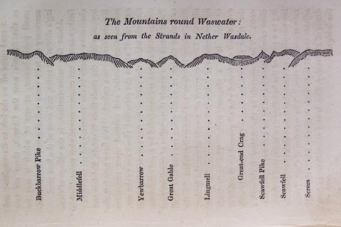 click to enlarge click to enlargeO75E08.jpg p.129 in A Concise Description of the English Lakes, by Jonathan Otley, 4th edition, 1830. "The Mountains round Wastwater: / as seen from the Strands in Nether Wasdale." "Buckbarrow Pike / Middlefell / Yewbarrow / Great Gable / Lingmell / Great-end Crag / Scawfell Pike / Scawfell / Screes" item:- Armitt Library : A1175.8 Image © see bottom of page |
|||||||||||||||||||||||||||||||||||||||||||||||||||||
|
|
||||||||||||||||||||||||||||||||||||||||||||||||||||||
| evidence:- | outline view:- Otley 1823 (8th edn 1849) placename:- Scawfell Pike |
|||||||||||||||||||||||||||||||||||||||||||||||||||||
| source data:- | Engraving, outline view of mountains, Windermere looking towards the West from the
Road between Troutbeck and Bowness, drawn by T Binns, engraved by O Jewitt, opposite
p.4 of A Descriptive Guide of the English Lakes, by Jonathan Otley, 8th edition, 1849.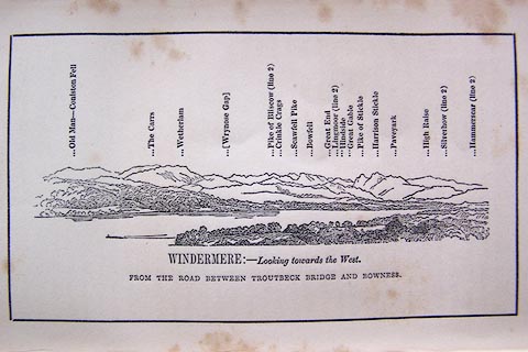 click to enlarge click to enlargeO80E03.jpg item:- Armitt Library : A1180.4 Image © see bottom of page |
|||||||||||||||||||||||||||||||||||||||||||||||||||||
|
|
||||||||||||||||||||||||||||||||||||||||||||||||||||||
| evidence:- | outline view:- Otley 1823 (8th edn 1849) placename:- Scawfell Pike |
|||||||||||||||||||||||||||||||||||||||||||||||||||||
| source data:- | Engraving, outline view of mountains, Derwent Water from Crow Park, drawn by T Binns,
engraved by O Jewitt, opposite p.10 of A Descriptive Guide of the English Lakes, by
Jonathan Otley, 8th edition, 1849.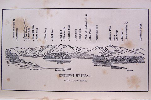 click to enlarge click to enlargeO80E06.jpg item:- Armitt Library : A1180.7 Image © see bottom of page |
|||||||||||||||||||||||||||||||||||||||||||||||||||||
|
|
||||||||||||||||||||||||||||||||||||||||||||||||||||||
| evidence:- | outline view:- Otley 1823 (8th edn 1849) placename:- Scawfell Pike |
|||||||||||||||||||||||||||||||||||||||||||||||||||||
| source data:- | Engraving, outline view of mountains, Mountains of Wast Water as seen from Nether
Wasdale, drawn by T Binns, engraved by O Jewitt, opposite p.22 of A Descriptive Guide
of the English Lakes, by Jonathan Otley, 8th edition, 1849.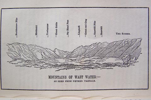 click to enlarge click to enlargeO80E13.jpg item:- Armitt Library : A1180.14 Image © see bottom of page |
|||||||||||||||||||||||||||||||||||||||||||||||||||||
|
|
||||||||||||||||||||||||||||||||||||||||||||||||||||||
| evidence:- | outline view:- Otley 1823 (8th edn 1849) placename:- Scawfell Pike |
|||||||||||||||||||||||||||||||||||||||||||||||||||||
| source data:- | Engraving, outline view of mountains, A Group of Mountains seen from Helvellyn, looking
towards the South West, drawn by T Binns, engraved by O Jewitt, opposite p.50 of A
Descriptive Guide of the English Lakes, by Jonathan Otley, 8th edition, 1849.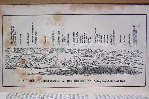 click to enlarge click to enlargeO80E17.jpg item:- Armitt Library : A1180.18 Image © see bottom of page |
|||||||||||||||||||||||||||||||||||||||||||||||||||||
|
|
||||||||||||||||||||||||||||||||||||||||||||||||||||||
| evidence:- | outline view:- Otley 1823 (5th edn 1834) placename:- Scawfell Pike |
|||||||||||||||||||||||||||||||||||||||||||||||||||||
| source data:- | Print, woodcut outline view, Mountains of Wast Water, by
Jonathan Otley, Keswick, Cumberland, 1830.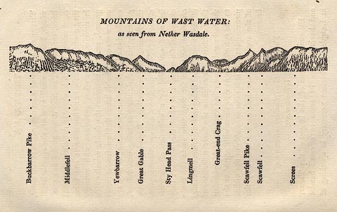 click to enlarge click to enlargeOT2E07.jpg Printed on p.31 of A Concise Description of the English Lakes, by Jonathan Otley, 5th edition, 1834. "THE MOUNTAINS OF WAST WATER: as seen from Nether Wasdale." "Buckbarrow Pike / Middlefell / Yewbarrow / Great Gable / Sty Head Pass / Lingmell / Great-end Crag / Scawfell Pike / Scawfell / Screes" item:- JandMN : 48.8 Image © see bottom of page |
|||||||||||||||||||||||||||||||||||||||||||||||||||||
|
|
||||||||||||||||||||||||||||||||||||||||||||||||||||||
| evidence:- | descriptive text:- Otley 1823 (5th edn 1834) placename:- Scawfell Pike placename:- Pikes, The item:- Mudge, Colonel; moss; geology; lichen geographicus; lichen; Rhizocarpon geographicum (?); viewpoint item:- bearings |
|||||||||||||||||||||||||||||||||||||||||||||||||||||
| source data:- | Guide book, A Concise Description of the English Lakes, the
mountains in their vicinity, and the roads by which they may be
visited, with remarks on the mineralogy and geology of the
district, by Jonathan Otley, published by the author, Keswick,
Cumberland now Cumbria, by J Richardson, London, and by Arthur
Foster, Kirkby Lonsdale, Cumbria, 1823; published 1823-49,
latterly as the Descriptive Guide to the English Lakes. goto source Page 64:- "SCAWFELL AND THE PIKES." "Scawfell is the name that has generally been given, in maps, to the mountain connecting the heads of Borrowdale, Eskdale, and Wasdale. It is the highest ground in all this mountainous district, and indeed in that part of the united kingdom called England. The several lofty peaks by which it is distinguished are known in the neighbourhood by different names. The two most eminent are stated by Colonel Mudge, to be 3166 and 3092 feet in height: ..." goto sourcePage 65:- "..." "The lower of these points, lying to the south-west, is a bulky mountain - the proper Scawfell; the higher rising from a narrower base, has been called the Pikes. For want of a designation sufficiently explicit, strangers have sometimes been mistakenly directed to the secondary point; and to cross the deep chasm of Mickle Door, by which they are separated, is a work of considerable difficulty; although the direct distance does not exceed three quarters of a mile. ..." "Excepting some tufts of moss, very little vegetation is to be seen upon these summits. They are chiefly composed of rocks, and large blocks of stone piled one upon another; and their weather-worn surfaces prove that they have long remained in their present state. The prevailing rock is a kind of indurated slate, in layers of finer and coarser materials, which gives to the surface a ribbed or furrowed appearance; the finer parts are compact and hard as flint: and here the lichen geographicus appears in peculiar beauty." goto sourcePage 66:- "... the ruggedness of the ground, and the danger of being caught in a cloud - to which, from its situation, it is more subject than its neighbours - altogether conspire against its being visited by any other than hardy pedestrians: and strangers should so calculate their time that night may not overtake them on such places. To be enveloped in a cloud is of itself disagreeable; cloud and night together would be dreadful." goto sourcePage 67:- "..." "The divergency of several vallies from this point, has been compared to the spokes of a wheel; and in tracing their courses upon a map, the simile may be applicable enough; but, upon the spot, the resemblance is not so striking - the mountains run athwart one another in such a way, that little can be seen of the intervening vallies." "..." goto sourcePage 155:- "The SECOND division [of slate rocks] comprehends the mountains of Eskdale, Wasdale, Ennerdale, Borrowdale, Langdale, Grasmere, Patterdale, Martindale, Mardale, and some adjacent places; including the two highest mountains of the district, Scawfell and Helvellyn, as well as the Old Man at Coniston. All our fine towering crags belong to it; and most of the cascades among the lakes fall over it. There are indeed some lofty precipices in the former division; ..." "..." goto sourcePage 78:- "STATION I.- SCAWFELL highest point, THE PIKES." Latitude 54° 27′ 24″ N. Longitude 3° 12′W. Height 3160 feet.
|
|||||||||||||||||||||||||||||||||||||||||||||||||||||
|
|
||||||||||||||||||||||||||||||||||||||||||||||||||||||
| evidence:- | descriptive text:- Ford 1839 (3rd edn 1843) placename:- Scafell Pikes placename:- Sca Fell Pike item:- lichen; Geographicus lychnicus; altitude, Scafell Pike |
|||||||||||||||||||||||||||||||||||||||||||||||||||||
| source data:- | Guide book, A Description of Scenery in the Lake District, by
Rev William Ford, published by Charles Thurnam, Carlisle, by W
Edwards, 12 Ave Maria Lane, Charles Tilt, Fleet Street, William
Smith, 113 Fleet Street, London, by Currie and Bowman,
Newcastle, by Bancks and Co, Manchester, by Oliver and Boyd,
Edinburgh, and by Sinclair, Dumfries, 1839. goto source Page 70:- "..." "SCAFELL PIKES" "... The South Pike, which is three thousand and ninety-two feet in height, is most accessible from Wastdale or Eskdale. This aspiring pinnacle presents a more sublime and not less elegantly-varied range of mountains, dales, and sea views, than either Helvellyn or Skiddaw; a considerable part of the Lancashire, Cumberland, and Scotch coasts, with the Isle of Man and Snowdon in Wales being visible. The Pike which is three thousand one hundred and sixty feet in height on the north peak of the fell, commands a view of Windermere and Derwent lakes; and, upon the whole, presents a more com-" goto sourcePage 71:- "[com]plete panorama than any other point. These, though only twelve hundred yards in a direct distance, are separated by a chasm called the Mickle Door, costing a distance of two miles' sever travelling to overcome. Very little or rather no vegetation is to be seen on this fell; rocks, and large blocks of stone piled one upon another, are the principal features, and the geographicus lychnicus appears in particular beauty. The distance of Scafell from any house of entertainment, the rugged ground, and the danger of being caught in mists, prevent this mountain from being visited by any but hardy pedestrians, neither would we recommend such even to venture without a guide." goto sourcePage 178:- "ELEVATION OF THE MOUNTAINS," "ACCORDING TO DIFFERENT AUTHORITIES."
|
|||||||||||||||||||||||||||||||||||||||||||||||||||||
|
|
||||||||||||||||||||||||||||||||||||||||||||||||||||||
| evidence:- | old text:- Miller 1847 placename:- Sca Fell item:- rain gauge; rainfall |
|||||||||||||||||||||||||||||||||||||||||||||||||||||
| source data:- | Book, Report on the Fall of Rain in the Lake Districts of
Cumberland and Westmoreland in 1846, by John Fletcher Miller,
printed by G Irwin, Lowther Street, Whitehaven, Cumberland, 1847. goto source Page 4:- "Note. The Lake district Gauges are five inches in diameter; they are all of the same construction, and are elevated about eighteen inches above the surface. The funnel rims are of stout sheet brass, so that the apertures cannot readily lose their circular form. The Metres were all made by Bate of the Poultry, London. - The Rain is read off daily at 9 A.M." "..." goto sourcePage 8:- 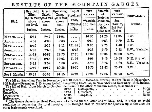 MI02Tab3.jpg goto sourcePage 9:- "REMARKS ON MOUNTAIN GAUGES." "The Mountain Gauges are on pretty much the same construction as those in the vallies, but the receivers are much more capacious, being calculated to hold nearly 80 inches of Rain." "The contents of the Gauges on Sca Fell and Gabel, have been frozen at the close of every month since October last; and as there is still no immediate prospect of our being able to measure off the water, I have concluded to publish the results obtained, without further delay: and, in the next report, I propose to give the whole monthly readings for 1846 and 1847 in one table." "..." "The Gauges on Sca Fell, Gabel, and Seatollar, are on the extreme summits of these monntains; and the whole of the instruments are freely exposed to the action of wind and rain, from almost every point of the compass." "..."
|
|||||||||||||||||||||||||||||||||||||||||||||||||||||
|
|
||||||||||||||||||||||||||||||||||||||||||||||||||||||
| evidence:- | old map:- Garnett 1850s-60s H placename:- Pikes placename:- Scawfell |
|||||||||||||||||||||||||||||||||||||||||||||||||||||
| source data:- | Map of the English Lakes, in Cumberland, Westmorland and
Lancashire, scale about 3.5 miles to 1 inch, published by John
Garnett, Windermere, Westmorland, 1850s-60s. GAR2NY20.jpg "Pikes / Scawfell" hill hachuring item:- JandMN : 82.1 Image © see bottom of page |
|||||||||||||||||||||||||||||||||||||||||||||||||||||
|
|
||||||||||||||||||||||||||||||||||||||||||||||||||||||
| evidence:- | outline view:- Martineau 1855 placename:- Scawfell Pike |
|||||||||||||||||||||||||||||||||||||||||||||||||||||
| source data:- | Print, engraving, outline view, Mountains on the West Side of Windermere, drawn by
L Aspland, engraved by W Banks, Edinburgh, published by John Garnett, Windermere,
Westmorland, and by Whittaker and Co, London, 1855.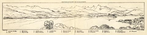 click to enlarge click to enlargeMNU102.jpg Folded in opposite p.7 in A Complete Guide to the English Lakes, by Harriet Martineau. "MOUNTAINS ON THE WEST SIDE OF WINDERMERE" "L Aspland Delt. / W Banks Sc Edinburgh." The view is captioned, numbers referring to mountains in the image:- "1 Coniston Old Man 1a Carrs 2 Wetherlam 3 Wrynose Gap 4 Crinkle Crags 5 Pike of Bliscow 6 Scawfell Pike 7 Bowfell 8 Hanging Knotts 9 Glaramara 10 Great End 11 Pike of Stickle 12 Harrison Stickle 13 Paveyark 14 Lingmoor 15 High Raise 16 Silver How 17 Loughrigg Fell 18 Ullscarth" item:- Armitt Library : A1159.2 Image © see bottom of page |
|||||||||||||||||||||||||||||||||||||||||||||||||||||
|
|
||||||||||||||||||||||||||||||||||||||||||||||||||||||
| evidence:- | outline view:- Martineau 1855 |
|||||||||||||||||||||||||||||||||||||||||||||||||||||
| source data:- | Print, engraving, outline view, Mountains seen from Lanthwaite Wood Crummock Water,
drawn by L Aspland, engraved by W Banks, Edinburgh, published by John Garnett, Windermere,
Westmorland, and by Whittaker and Co, London, 1855.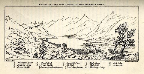 click to enlarge click to enlargeMNU113.jpg Opposite p.84 in A Complete Guide to the English Lakes, by Harriet Martineau. The view is captioned, numbers referring to mountains in the image:- "1 Whiteless Pike, 2 Honister Crag, 3 Green Gable, 4 Great End, 5 Great Gable / Rannerdale Knott (beneath), 6 Scawfell Pike, 7 Kirkfell / Scarf Gap (below), 8 High Crag, 9 High Stile, 10 Bleaberry Crag, 11 Red Pike, 12 Melbreak." "MOUNTAINS SEEN FROM LANTHWAITE WOOD CRUMMOCK WATER." "L Aspland Delt. / W Banks Sc Edinr." item:- Armitt Library : A1159.13 Image © see bottom of page |
|||||||||||||||||||||||||||||||||||||||||||||||||||||
|
|
||||||||||||||||||||||||||||||||||||||||||||||||||||||
| evidence:- | outline view:- Martineau 1855 placename:- Scawfell Pike |
|||||||||||||||||||||||||||||||||||||||||||||||||||||
| source data:- | Print, engraving, outline view, Mountains seen from Applethwaite near Keswick, drawn
by L Aspland, engraved by W Banks, Edinburgh, published by John Garnett, Windermere,
Westmorland, and by Whittaker and Co, London, 1855.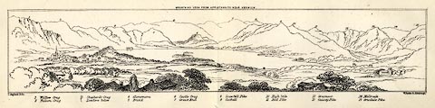 click to enlarge click to enlargeMNU114.jpg Plate, opposite p.93 in A Complete Guide to the English Lakes, by Harriet Martineau. "MOUNTAINS SEEN FROM APPLETHWAITE NEAR KESWICK." "L Aspland Delt. / W Banks Sc Edinr." The view is captioned, numbers referring to mountains in the image:- "1 Wallow Crag, 2 Falcon Crag, 3 Shepherd's Crag / Lowdore below, 4 Glaramara, 5 Brund, 6 Castle Crag, 7 Great End, 8 Scawfell Pike, 9 Catbell, 10, High Stile, 11 Red Pike, 12 Grasmoor, 13 Causey Pike, 14 Melbreak, 15 Grisdale Pike" item:- Armitt Library : A1159.14 Image © see bottom of page |
|||||||||||||||||||||||||||||||||||||||||||||||||||||
|
|
||||||||||||||||||||||||||||||||||||||||||||||||||||||
| evidence:- | old text:- Martineau 1855 placename:- Scawfell Pike item:- trig point; altitude, Scafell Pike |
|||||||||||||||||||||||||||||||||||||||||||||||||||||
| source data:- | Guide book, A Complete Guide to the English Lakes, by Harriet
Martineau, published by John Garnett, Windermere, Westmorland,
and by Whittaker and Co, London, 1855; published 1855-76. goto source Page 157:- "... There are four summits which collectively go under the name of Scawfell; viz, the most southerly, which is called simply Scawfell; Scawfell Pike, which is sixty feet higher, and the highest mountain in England (3,160 feet:) ... The Ordnance surveyors set up a staff on a pile of stones on the highest peak; so that there need be no mistake henceforth. ..." |
|||||||||||||||||||||||||||||||||||||||||||||||||||||
|
|
||||||||||||||||||||||||||||||||||||||||||||||||||||||
| evidence:- | old text:- Martineau 1855 placename:- Scawfell Pikes item:- altitude, Scafell Pike |
|||||||||||||||||||||||||||||||||||||||||||||||||||||
| source data:- | Guide book, A Complete Guide to the English Lakes, by Harriet
Martineau, published by John Garnett, Windermere, Westmorland,
and by Whittaker and Co, London, 1855; published 1855-76. goto source Page 179:- "A TABLE OF THE HEIGHTS OF MOUNTAINS IN THE COUNTIES OF CUMBERLAND, WESTMORLAND, AND LANCASHIRE." "No. : Names of Mountains. : Counties. : Height in Feet above the Sea Level." "1 : Scawfell Pikes : Cumberland : 3160" |
|||||||||||||||||||||||||||||||||||||||||||||||||||||
|
|
||||||||||||||||||||||||||||||||||||||||||||||||||||||
| evidence:- | descriptive text:- Clarke 1858 placename:- Sca Fell Pike |
|||||||||||||||||||||||||||||||||||||||||||||||||||||
| source data:- | Report, Account of the Observations and Calculations of the
Principal Triangulation, by Captain Alexander Ross Clarke,
published by the Ordnance Survey, London, 1858. "SCA FELL PIKE, 1841. This hill lies between Eskdale and Wastdale, in the county of Cumberland; its summit is about three quarters of a mile north-east of Sca Fell, from which it is separated by a deep chasm called the Mickle Door. The station is marked by a pile, 21 feet high and 18 feet in diameter, beneath which the frame on which the instrument stood, and a centre stone with a hole in it marking the exact centre of this station, will be found. The nearest houses are at Wastdale Head, from whence the station is best approached." "SCA FELL 3-ft. Theodolite, R.S. From 8th July to 20th September 1841. Observers: Lieuts. PIPON and CRAIGIE, R.E." Objects / Bearings in degrees, minutes and decimal seconds. "Blackcomb / 19 14 52.80" "Snowdon / 20 38 31.85" "Llanelian / 31 45 38.86" "Holyhead / 37 45 50.86" "South Berule / 70 55 36.88" "Snea Fell / 75 51 16.39" "North Berule / 77 7 0.84" "Mull of Galloway / 101 23 34.47" "Dent Hill / 107 11 2.27" "Glasserton / 109 41 21.28" "Cairnsmuir of Fleet / 128 59 39.77" "Merrick / 133 [50] 41.88" "Ben Cairn / 135 45 48.06" "Cairnsmuir on Deugh / 144 37 56.91" "Criffel / 153 45 43.29" "Hart Fell / 173 32 25.97" "Wisp / 189 31 25.96" "High Pike / 199 23 59.43" "Cheviot / 210 28 54.36" "Helvellyn / 237 7 18.55" "Cross Fell / 239 6 52.22" "Water Crag / 271 6 11.28" "Calf / 281 41 13.39" "Great Whernside / 291 58 11.83" "Little Whernside / 295 16 15.73" "Ingleboro' / 300 50 23.35" "Boulsworth / 314 4 59.20" "Pendle / 317 10 43.86" "Whittle Hill / 324 23 43.98" "Bery / 350 43 43.12" Altitude above mean sea level:- "(Sca Fell) 3229.6 feet" Position, latitude and longitude, degrees minutes decimal seconds "(Sca Fell) 54 27 14.89 / 3 12 35.34" The altitude and position figures are given for 'Sca Fell'; it is not clear that this is this is Scawfell Pike. |
|||||||||||||||||||||||||||||||||||||||||||||||||||||
|
|
||||||||||||||||||||||||||||||||||||||||||||||||||||||
| evidence:- | old photograph:- Bell 1880s-1940s |
|||||||||||||||||||||||||||||||||||||||||||||||||||||
| source data:- | Photograph, sepia, head of Eskdale, and Sca Fell, Cumberland, by Herbert Bell, photographer,
Ambleside, Westmorland, 1890s. click to enlarge click to enlargeHB0910.jpg item:- Armitt Library : ALPS585 Image © see bottom of page |
|||||||||||||||||||||||||||||||||||||||||||||||||||||
|
|
||||||||||||||||||||||||||||||||||||||||||||||||||||||
| evidence:- | old photograph:- Bell 1880s-1940s |
|||||||||||||||||||||||||||||||||||||||||||||||||||||
| source data:- | Photograph, black and white, view from Scafell Pike, Eskdale, Cumberland, by Herbert
Bell, photographer, Ambleside, Westmorland, 1890s. click to enlarge click to enlargeHB0906.jpg item:- Armitt Library : ALPS581 Image © see bottom of page |
|||||||||||||||||||||||||||||||||||||||||||||||||||||
|
|
||||||||||||||||||||||||||||||||||||||||||||||||||||||
| evidence:- | old photograph:- Bell 1880s-1940s item:- boat; rowing boat |
|||||||||||||||||||||||||||||||||||||||||||||||||||||
| source data:- | Photograph, black and white, Lingmell, Nether Wasdale and Scafell Pike, Eskdale, Cumberland,
by Herbert Bell, photographer, Ambleside, Westmorland, 1890s.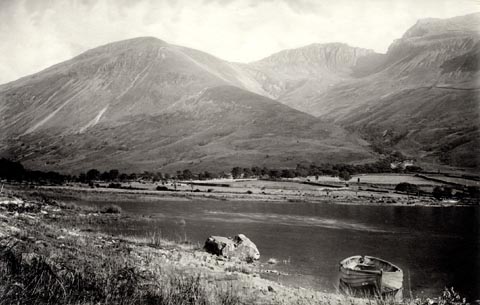 click to enlarge click to enlargeHB0883.jpg internegative at lower left:- "H. Bell" item:- Armitt Library : ALPS554 Image © see bottom of page |
|||||||||||||||||||||||||||||||||||||||||||||||||||||
|
|
||||||||||||||||||||||||||||||||||||||||||||||||||||||
| evidence:- | old photograph:- Bell 1880s-1940s |
|||||||||||||||||||||||||||||||||||||||||||||||||||||
| source data:- | Photograph, black and white, Scafell Pike, Eskdale, Cumberland, by Herbert Bell, photographer,
Ambleside, Westmorland, 1890s.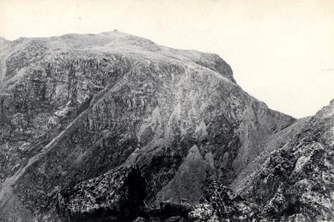 click to enlarge click to enlargeHB0707.jpg stamped on reverse:- "HERBERT BELL / Photographer / AMBLESIDE" item:- Armitt Library : ALPS371 Image © see bottom of page |
|||||||||||||||||||||||||||||||||||||||||||||||||||||
|
|
||||||||||||||||||||||||||||||||||||||||||||||||||||||
| evidence:- | old photograph:- Bell 1880s-1940s |
|||||||||||||||||||||||||||||||||||||||||||||||||||||
| source data:- | Photograph, black and white, Scafell Pike, Eskdale, Cumberland, by Herbert Bell, photographer,
Ambleside, Westmorland, 1890s.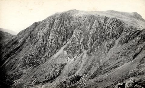 click to enlarge click to enlargeHB0706.jpg internegative at lower left:- "H. Bell" stamped on reverse:- "HERBERT BELL / Photographer / AMBLESIDE" item:- Armitt Library : ALPS370 Image © see bottom of page |
|||||||||||||||||||||||||||||||||||||||||||||||||||||
|
|
||||||||||||||||||||||||||||||||||||||||||||||||||||||
| evidence:- | old photograph:- Bell 1880s-1940s |
|||||||||||||||||||||||||||||||||||||||||||||||||||||
| source data:- | Photograph, black and white, head of Eskdale, and Sca Fell, Cumberland, by Herbert
Bell, Ambleside, Westmorland, 1890s.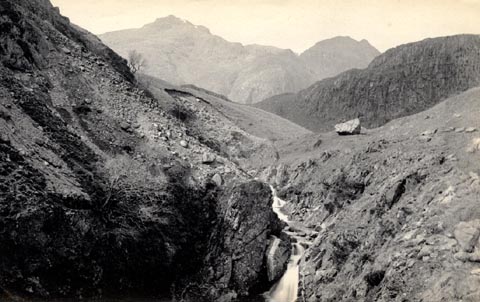 click to enlarge click to enlargeHB0522.jpg item:- Armitt Library : ALPS185 Image © see bottom of page |
|||||||||||||||||||||||||||||||||||||||||||||||||||||
|
|
||||||||||||||||||||||||||||||||||||||||||||||||||||||
| evidence:- | text:- Mason 1907 (edn 1930) item:- altitude, mountains |
|||||||||||||||||||||||||||||||||||||||||||||||||||||
| source data:- | Text book, The Ambleside Geography Books bk.III, The Counties of
England, by Charlotte M Mason, published by Kegan Paul, Trench,
Trubner and Co, Broadway House, 68-74 Carter Lane, and the
Parents' Educational Union Office, 26 Victoria Street, London,
edn 1930. MSN1P020.txt Page 20:- "..." "Helvellyn is the monarch of the lake mountains: Sca Fell is a hundred feet higher; Skiddaw, Sca Fell, and Helvellyn are all over 3000 feet; but neither of the others is such a big, swelling, giant of a mountain as Helvellyn." MSN1P023.txt Page 23:- "..." "... to know that ... Sca Fell Pikes and Langdale Pikes - are pairs of giants with rounded heads, that you may always recognise." |
|||||||||||||||||||||||||||||||||||||||||||||||||||||
|
|
||||||||||||||||||||||||||||||||||||||||||||||||||||||
| evidence:- | outline view:- Seascale 1920s-30s placename:- Scawfell Pike |
|||||||||||||||||||||||||||||||||||||||||||||||||||||
| source data:- | Print, uncoloured engraving, outline view, mountains from Seascale, published by Edward
Burrow and Son, Cheltenham, Gloucestershire, 1920s-30s.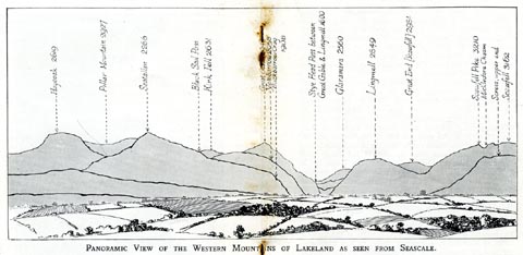 click to enlarge click to enlargeSES113.jpg "PANORAMIC VIEW OF THE WESTERN MOUNTAINS OF LAKELAND AS SEEN FROM SEASCALE." "... Scawfell Pike 3210 ..." item:- JandMN : 1079.13 Image © see bottom of page |
|||||||||||||||||||||||||||||||||||||||||||||||||||||
|
|
||||||||||||||||||||||||||||||||||||||||||||||||||||||
| evidence:- | old print:- Barber and Atkinson 1927 placename:- Scafell |
|||||||||||||||||||||||||||||||||||||||||||||||||||||
| source data:- | Print, halftone photograph, Scafell, from Hardknott Pass, Cumberland, by E H Atkinson,
published by James Atkinson, Caxton Printing Works, Ulverston, Lancashire, 1928.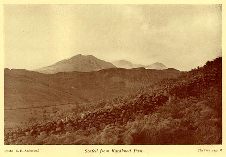 click to enlarge click to enlargeAK0402.jpg Tipped in opposite p.17 of Lakeland Passes, by John B Barber and George Atkinson, 1927, 3rd edn 1928. printed at bottom:- "Photo E. H. Atkinson) Scafell from Hardknott Pass. (To face plage 17." item:- JandMN : 350.3 Image © see bottom of page |
|||||||||||||||||||||||||||||||||||||||||||||||||||||
|
|
||||||||||||||||||||||||||||||||||||||||||||||||||||||
| evidence:- | outline view:- LMS 1920s |
|||||||||||||||||||||||||||||||||||||||||||||||||||||
| source data:- | Hills of Lakeland in Outline, published in the LMS Route Book No.3, The Track of the
Royal Scot, by the London, Midland and Scottish Railway, LMS, 1920s.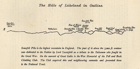 click to enlarge click to enlargeLS1E32.jpg item:- JandMN : 95.5 Image © see bottom of page |
|||||||||||||||||||||||||||||||||||||||||||||||||||||
|
|
||||||||||||||||||||||||||||||||||||||||||||||||||||||
| evidence:- | old photograph:- Bogg 1898 item:- climbing; Moss Ghyll |
|||||||||||||||||||||||||||||||||||||||||||||||||||||
| source data:- | Photograph, halftone print, Moss Ghyll from Rake's Progress, Scafell Pike, Ennerdale
and Kinniside, Cumberland, by F Leach, published by Edmund Bogg, 3 Woodhouse Lane,
and James Miles, Guildford Street, Leeds, Yorkshire, 1898.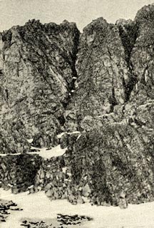 click to enlarge click to enlargeBGG155.jpg Included on p.166 of Lakeland and Ribblesdale, by Edmund Bogg. item:- JandMN : 231.55 Image © see bottom of page |
|||||||||||||||||||||||||||||||||||||||||||||||||||||
|
|
||||||||||||||||||||||||||||||||||||||||||||||||||||||
| evidence:- | old print:- Bogg 1898 item:- climbing |
|||||||||||||||||||||||||||||||||||||||||||||||||||||
| source data:- | Print, engraving, Outline Sketch of Scafell, Eskdale, Cumberland, 1893 from a photograph
by Prof. Dixon, published by Edmund Bogg, 3 Woodhouse Lane, and James Miles, Guildford
Street, Leeds, Yorkshire, 1898.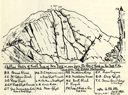 click to enlarge click to enlargeBGG153.jpg Included on p.164 of Lakeland and Ribblesdale, by Edmund Bogg. item:- JandMN : 231.53 Image © see bottom of page |
|||||||||||||||||||||||||||||||||||||||||||||||||||||
|
|
||||||||||||||||||||||||||||||||||||||||||||||||||||||
| evidence:- | outline view:- Jenkinson 1875 placename:- Scawfell Pikes |
|||||||||||||||||||||||||||||||||||||||||||||||||||||
| source data:- | Print, lithograph, outline view, Panoramic Sketches from Helvellyn, Westmorland, by
Edwin A Pettitt, London, published by Edward Stanford, 55 Charing Cross, London, 1875. click to enlarge click to enlargeJk01E1.jpg "... Scawfell Pikes ..." item:- JandMN : 28.5 Image © see bottom of page |
|||||||||||||||||||||||||||||||||||||||||||||||||||||
|
|
||||||||||||||||||||||||||||||||||||||||||||||||||||||
| evidence:- | outline view:- Jenkinson 1875 placename:- Scawfell Pikes |
|||||||||||||||||||||||||||||||||||||||||||||||||||||
| source data:- | Print, lithograph, outline view, Panoramic Sketches from Skiddaw, Cumberland, by Edwin
A Pettitt, London, published by Edward Stanford, 55 Charing Cross, London, 1875. click to enlarge click to enlargeJk01E2.jpg "... Scawfell Pikes ..." item:- JandMN : 28.8 Image © see bottom of page |
|||||||||||||||||||||||||||||||||||||||||||||||||||||
|
|
||||||||||||||||||||||||||||||||||||||||||||||||||||||
| evidence:- | outline view:- Jenkinson 1875 placename:- Scawfell Pikes |
|||||||||||||||||||||||||||||||||||||||||||||||||||||
| source data:- | Print, lithograph, outline view, Panoramic Sketches from Scawfell Pike, Cumberland,
by Edwin A Pettitt, London, published by Edward Stanford, 55 Charing Cross, London,
1875. click to enlarge click to enlargeJk01E3.jpg "... Scawfell Pike (second) ... Scawfell Pike (first) ..." item:- JandMN : 28.9 Image © see bottom of page |
|||||||||||||||||||||||||||||||||||||||||||||||||||||
|
|
||||||||||||||||||||||||||||||||||||||||||||||||||||||
| evidence:- | outline view:- Matthew 1866 placename:- Scawfell Pike |
|||||||||||||||||||||||||||||||||||||||||||||||||||||
| source data:- | Print, engraving, outline view, Mountains as seen from the Road to Wastwater near
Murthwaiteside, Cumberland, published by J Richardson, Highgate, Kendal, Westmorland,
1866.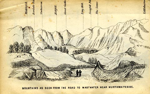 click to enlarge click to enlargeMW1E03.jpg Tipped in before p.1 of The English Lakes, Peaks and Passes, from Kendal to Keswick, by George King Matthew. printed at bottom:- "MOUNTAINS AS SEEN FROM THE ROAD TO WASTWATER NEAR MURTHWAITESIDE." printed at caption to mountains:- "... Scawfell Pik[ ] ..." item:- Armitt Library : A1168.3 Image © see bottom of page |
|||||||||||||||||||||||||||||||||||||||||||||||||||||
|
|
||||||||||||||||||||||||||||||||||||||||||||||||||||||
| evidence:- | old print:- Prior 1865 placename:- Scafell Pike |
|||||||||||||||||||||||||||||||||||||||||||||||||||||
| source data:- | Print, uncoloured engraving, Sty Head Tarn, Scafell Pike, and Scafell, in Borrowdale
and in Eskdale, Cumberland, published by John Garnett, Windermere, Westmorland, and
by Simpkin, Marshall and Co, London, 1865.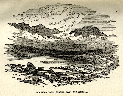 click to enlarge click to enlargePI0106.jpg Included on page 39 of the guide book, Ascents and Passes in the Lake District of England, by Herman Prior. printed at bottom:- "STY HAD TARN, SCAFELL PIKE, AND SCAFELL." item:- JandMN : 235.8 Image © see bottom of page |
|||||||||||||||||||||||||||||||||||||||||||||||||||||
|
|
||||||||||||||||||||||||||||||||||||||||||||||||||||||
| evidence:- | outline view:- Black 1856 (23rd edn 1900) placename:- Scawfell Pike |
|||||||||||||||||||||||||||||||||||||||||||||||||||||
| source data:- | Print, lithograph, Outline Views, Windermere - Mountains as seen from the North End
of Belle Isle, Windermere, and Mountains as seen from Biscay How, Bowness, by J Flintoft,
Keswick, Cumberland, engraved by R Mason, Edinburgh, Lothian, about 1900.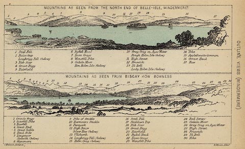 click to enlarge click to enlargeBC08E1.jpg "... 2 Scawfell Pike ..." item:- JandMN : 37.4 Image © see bottom of page |
|||||||||||||||||||||||||||||||||||||||||||||||||||||
|
|
||||||||||||||||||||||||||||||||||||||||||||||||||||||
| evidence:- | outline view:- Black 1856 (23rd edn 1900) placename:- Scawfell Pike |
|||||||||||||||||||||||||||||||||||||||||||||||||||||
| source data:- | Print, lithograph, Outline Views, Skiddaw and Derwent Water - Mountains as seen at
Lodore Hotel, and Mountains as seen at the Third Gate on Ascending Latrigg on the
Way to Skiddaw, by J Flintoft, Keswick, Cumberland, engraved by R Mason, Edinburgh,
Lothian, about 1900.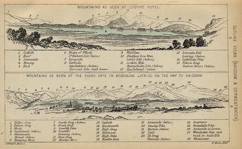 click to enlarge click to enlargeBC08E4.jpg "... 9 Scawfell Pike ..." item:- JandMN : 37.14 Image © see bottom of page |
|||||||||||||||||||||||||||||||||||||||||||||||||||||
|
|
||||||||||||||||||||||||||||||||||||||||||||||||||||||
| evidence:- | outline view:- Black 1856 (23rd edn 1900) placename:- Scawfell Pike |
|||||||||||||||||||||||||||||||||||||||||||||||||||||
| source data:- | Print, lithograph, Outline Views, Buttermere - Mountains as seen from the Knots near
the Hotel at Buttermere, and Mountains as seen at the Seat in Lanthwaite Wood, Scale
Hill, by J Flintoft, Keswick, Cumberland, engraved by R Mason, Edinburgh, Lothian,
about 1900. click to enlarge click to enlargeBC08E5.jpg "... 7 Scaw Fell High Pike ..." item:- JandMN : 37.19 Image © see bottom of page |
|||||||||||||||||||||||||||||||||||||||||||||||||||||
|
|
||||||||||||||||||||||||||||||||||||||||||||||||||||||
| evidence:- | outline view:- Black 1856 (23rd edn 1900) placename:- Scawfell Pike |
|||||||||||||||||||||||||||||||||||||||||||||||||||||
| source data:- | Print, lithograph, Outline Views, Haws and Wastwater - Mountains as seen from Burn-Banks
near the Foot of Hawes Water, and Mountains as seen near Nether Wastdale at the First
Bridge on the road to Wast-Water, by J Flintoft, Keswick, Cumberland, engraved by
R Mason, Edinburgh, Lothian, about 1900.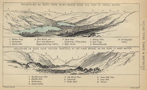 click to enlarge click to enlargeBC08E6.jpg "... 8 Scaw Fell Pike ..." item:- JandMN : 37.21 Image © see bottom of page |
|||||||||||||||||||||||||||||||||||||||||||||||||||||
|
|
||||||||||||||||||||||||||||||||||||||||||||||||||||||
| evidence:- | outline view:- Linton 1852 placename:- Scawfell Pike |
|||||||||||||||||||||||||||||||||||||||||||||||||||||
| source data:- | Print, engraving, outline views, Mountains as Seen from the Esk Viaduct, the Eskmeals
Viaduct, and Mountains as Seen from the Viaduct near Drigg, the Irt Viaduct, Whitehaven
and Furness Junction Railway, Cumberland, engraved by W H Lizars, Edinburgh, published
by Whittaker and Co, London, and by R Gibson and Son and by Callander and Dixon, Whitehaven,
Cumberland, 1852.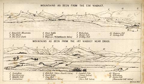 click to enlarge click to enlargeLN1E13.jpg Tipped in opposite p.86 of A Handbook of the Whitehaven and Furness Railway, by John Linton. item:- Armitt Library : A1158.11 Image © see bottom of page |
|||||||||||||||||||||||||||||||||||||||||||||||||||||
|
|
||||||||||||||||||||||||||||||||||||||||||||||||||||||
| evidence:- | outline view:- Black 1841 (3rd edn 1846) placename:- Scaw Fell Pike |
|||||||||||||||||||||||||||||||||||||||||||||||||||||
| source data:- | Print, engraving, outline view, Mountains as seen from the North End of Belle Isle,
Windermere, and Mountains as seen from Bisket How, Bowness, by J Flintoft, Keswick,
Cumberland, engraved by R Mason, Edinburgh, about 1844.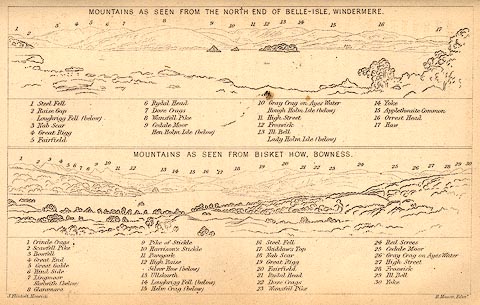 click to enlarge click to enlargeBC02E1.jpg "... 2 Scawfell Pike ..." item:- JandMN : 32.3 Image © see bottom of page |
|||||||||||||||||||||||||||||||||||||||||||||||||||||
|
|
||||||||||||||||||||||||||||||||||||||||||||||||||||||
| evidence:- | outline view:- Black 1841 (3rd edn 1846) placename:- Scaw Fell Pike |
|||||||||||||||||||||||||||||||||||||||||||||||||||||
| source data:- | Print, engraving, outline view, Mountains as seen at Lowdore Inn, and Mountains as
seen at the Third Gate on Ascending Latrigg on the Way to Skiddaw, by J Flintoft,
Keswick, Cumberland, engraved by R Mason, Edinburgh, Lothian, about 1846.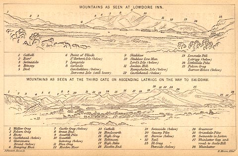 click to enlarge click to enlargeBC02E4.jpg "... 9 Scawfell Pike ..." item:- JandMN : 32.7 Image © see bottom of page |
|||||||||||||||||||||||||||||||||||||||||||||||||||||
|
|
||||||||||||||||||||||||||||||||||||||||||||||||||||||
| evidence:- | outline view:- Black 1841 (3rd edn 1846) placename:- Scaw Fell Pike |
|||||||||||||||||||||||||||||||||||||||||||||||||||||
| source data:- | Print, engraving, outline view, Mountains as seen from The Knots near the Victoria
at Buttermere, and Mountains as seen at the Seat in Lanthwaite Wood, Scale Hill, by
J Flintoft, Keswick, Cumberland, engraved by R Mason, Edinburgh, Lothian, about 1846.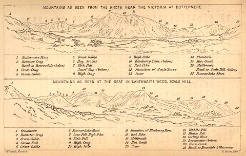 click to enlarge click to enlargeBC02E7.jpg "... 7 Scaw Fell High Pike ..." item:- JandMN : 32.11 Image © see bottom of page |
|||||||||||||||||||||||||||||||||||||||||||||||||||||
|
|
||||||||||||||||||||||||||||||||||||||||||||||||||||||
| evidence:- | outline view:- Black 1841 (3rd edn 1846) placename:- Scaw Fell Pike |
|||||||||||||||||||||||||||||||||||||||||||||||||||||
| source data:- | Print, engraving, outline view, Mountains as seen from Burn Banks near the Foot of
Hawes Water, and Mountains as seen near Strands in Wastdale at the First bridge on
the Road to Wast Water, by J Flintoft, Keswick, Cumberland, engraved by R Mason, Edinburgh,
Lothian, about 1846.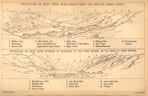 click to enlarge click to enlargeBC02E8.jpg "... 8 Scaw Fell Pike ..." item:- JandMN : 32.12 Image © see bottom of page |
|||||||||||||||||||||||||||||||||||||||||||||||||||||
|
|
||||||||||||||||||||||||||||||||||||||||||||||||||||||
| evidence:- | outline view:- Tattersall 1836 (version 1869) placename:- Scawfell Pikes |
|||||||||||||||||||||||||||||||||||||||||||||||||||||
| source data:- | Print, hand coloured, Wast Water and Scawfell Pikes, from the road to Calder Bridge,
Nether Wasdale, Cumberland, drawn by George Tattersall, 1836, engraved by W F Topham,
published by T J Allman, 463 Oxford Street, London, 1869.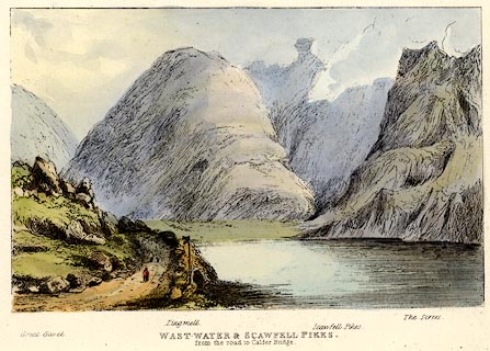 click to enlarge click to enlargeTAT214.jpg Included in The Lakes of England, by W F Topham. printed at bottom:- "WAST WATER &SCAWFELL PIKES, / from the road to Calder Bridge." printed at bottom:- "Great Gavel. / Lingmell. / Scawfell Pikes. / The Screes." item:- Armitt Library : A1067.14 Image © see bottom of page |
|||||||||||||||||||||||||||||||||||||||||||||||||||||
|
|
||||||||||||||||||||||||||||||||||||||||||||||||||||||
| evidence:- | outline view:- Tattersall 1836 (version 1869) placename:- Scawfell Pikes |
|||||||||||||||||||||||||||||||||||||||||||||||||||||
| source data:- | Print, hand coloured, Stye Head Tarn, Cumberland, drawn by George Tattersall, 1836,
engraved by W F Topham, published by T J Allman, 463 Oxford Street, London, 1869.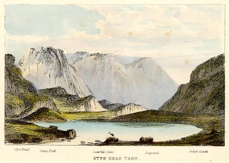 click to enlarge click to enlargeTAT213.jpg Included in The Lakes of England, by W F Topham. printed at bottom:- "STYE HEAD TARN." printed at bottom:- "Stye Head. / Great End. / Scawfell Pikes. / Lingmell. / Great Gavel." item:- Armitt Library : A1067.13 Image © see bottom of page |
|||||||||||||||||||||||||||||||||||||||||||||||||||||
|
|
||||||||||||||||||||||||||||||||||||||||||||||||||||||
| evidence:- | outline view:- Tattersall 1836 placename:- Scawfell Pikes item:- fingerpost |
|||||||||||||||||||||||||||||||||||||||||||||||||||||
| source data:- | Print, engraving, Wast Water and Scawfell Pikes, from the road to Calder Bridge, Nether
Wasdale, Cumberland, drawn by George Tattersall, engraved by W F Topham, published
by Sherwood and Co, Paternoster Row, London, about 1836.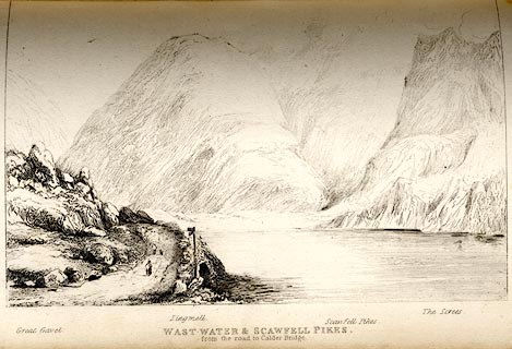 click to enlarge click to enlargeTAT132.jpg The print is captioned with mountain names and acts as an outline view. Tipped in opposite p.80 of The Lakes of England, by George Tattersall. printed at bottom:- "WAST WATER &SCAWFELL PIKES, / from the road to Calder Bridge." printed at bottom left to right:- "Great Gavel. / Lingmell. / Scawfell Pikes. / The Screes." item:- Armitt Library : A1204.33 Image © see bottom of page |
|||||||||||||||||||||||||||||||||||||||||||||||||||||
|
|
||||||||||||||||||||||||||||||||||||||||||||||||||||||
| evidence:- | outline view:- Tattersall 1836 placename:- Scawfell Pikes item:- heron |
|||||||||||||||||||||||||||||||||||||||||||||||||||||
| source data:- | Print, engraving, Stye Head Tarn, Borrowdale, Cumberland, drawn by George Tattersall,
engraved by W F Topham, published by Sherwood and Co, Paternoster Row, London, about
1836.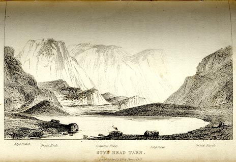 click to enlarge click to enlargeTAT131.jpg The print is captioned with mountain names and acts as an outline view. Tipped in opposite p.78 of The Lakes of England, by George Tattersall. printed at bottom:- "STYE HEAD TARN. / London Pubd. April 15th. 1836, by Sherwood &Co." printed at bottom left to right:- "Stye Head. / Great End. / Scawfell Pikes. / Lingmell. / Great Gavel." item:- Armitt Library : A1204.32 Image © see bottom of page |
|||||||||||||||||||||||||||||||||||||||||||||||||||||
|
|
||||||||||||||||||||||||||||||||||||||||||||||||||||||
| evidence:- | outline view:- placename:- Scawfell Pikes |
|||||||||||||||||||||||||||||||||||||||||||||||||||||
| source data:- | Print, hand coloured engraving, Wast Water and Scawfell Pikes from the Road to Calder
Bridge, Cumberland, published by Sherwood and Co, London, 1836?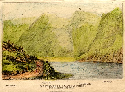 click to enlarge click to enlargePR0373.jpg Objects in the view are identified by a caption at the bottom - Great Gavel, Lingmell, Scawfell Pikes, The Screes. printed at bottom:- "WAST-WATER & SCAWFELL PIKES. / from the road to Calder Bridge. / London. Pubd. April 15th 1836 by Sherwood &Co." item:- Dove Cottage : 2008.107.373 Image © see bottom of page |
|||||||||||||||||||||||||||||||||||||||||||||||||||||
|
|
||||||||||||||||||||||||||||||||||||||||||||||||||||||
| evidence:- | old print:- Rose 1832-35 (vol.1 no.72) placename:- Scawfell Pikes |
|||||||||||||||||||||||||||||||||||||||||||||||||||||
| source data:- | Print, uncoloured engraving, Scawfell Pikes, from Sty Head, Cumberland, drawn by Thomas
Allom, engraved by J C Bentley, published by Fisher, Son and Co, London, 1833.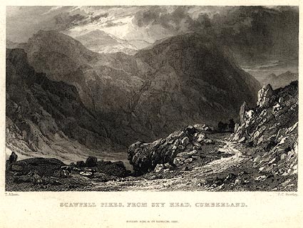 click to enlarge click to enlargePR0027.jpg vol.1 pl.72 in the set of prints, Westmorland, Cumberland, Durham and Northumberland Illustrated. printed at bottom left, right, centre:- "T. Allom. / J. C. Bentley. / SCAWFELL PIKES, FROM STY HEAD, CUMBERLAND. / FISHER, SON &CO. LONDON, 1833." item:- Dove Cottage : 2008.107.27 Image © see bottom of page |
|||||||||||||||||||||||||||||||||||||||||||||||||||||
|
|
||||||||||||||||||||||||||||||||||||||||||||||||||||||
| evidence:- | old print:- Rose 1832-35 placename:- Scawfell Pikes |
|||||||||||||||||||||||||||||||||||||||||||||||||||||
| source data:- | Print, engraving, Wastdale Head, Scawfell Pikes, Cumberland, by Thomas Allom, engraved
by S Lacey, 1833.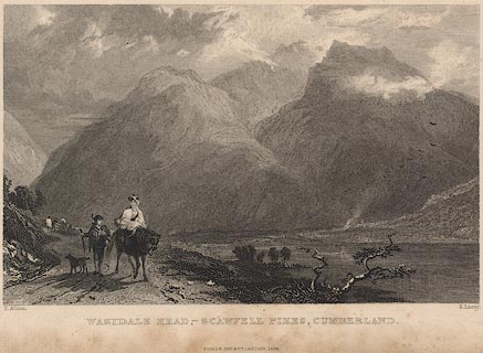 click to enlarge click to enlargeR258.jpg "Wastdale Head, Scawfell Pikes, Cumberland" item:- JandMN : 96.19 Image © see bottom of page |
|||||||||||||||||||||||||||||||||||||||||||||||||||||
|
|
||||||||||||||||||||||||||||||||||||||||||||||||||||||
 ascent 1800s ascent 1800s |
||||||||||||||||||||||||||||||||||||||||||||||||||||||
|
|
||||||||||||||||||||||||||||||||||||||||||||||||||||||
| ascent 1900 |
||||||||||||||||||||||||||||||||||||||||||||||||||||||
|
|
||||||||||||||||||||||||||||||||||||||||||||||||||||||
 BMB41.jpg (taken 11.5.2006)  BNV02.jpg (taken 9.6.2007) 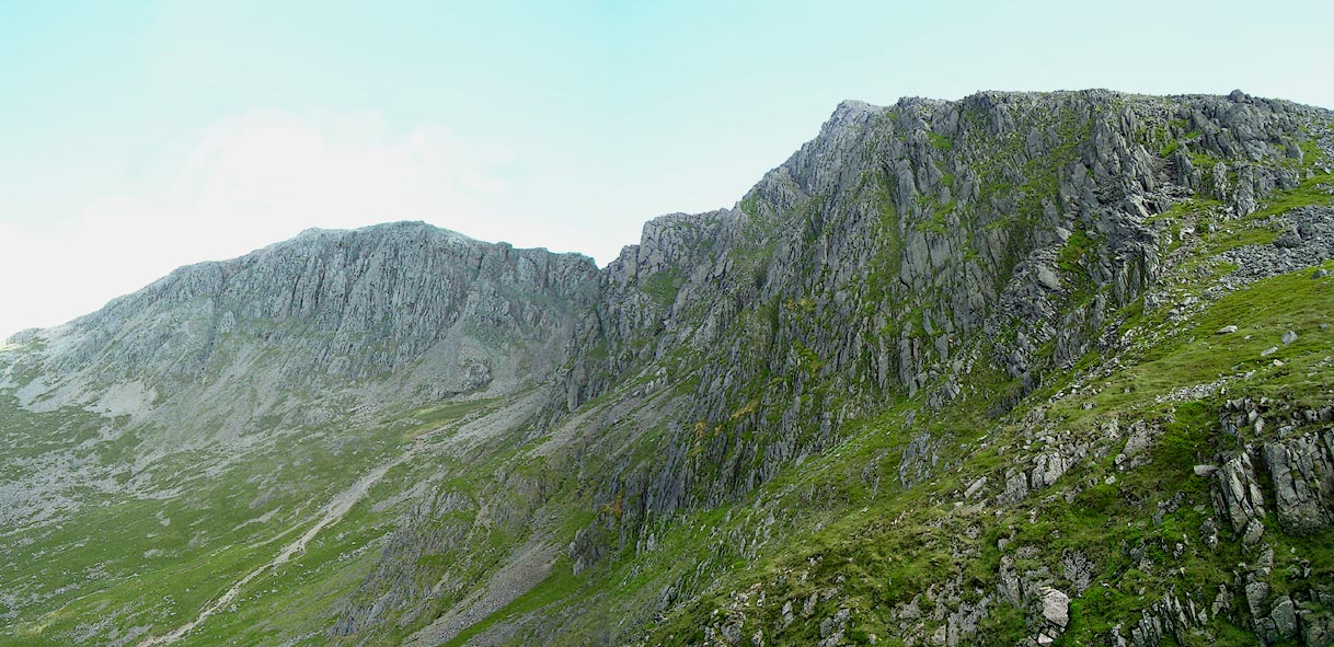 Click to enlarge BNV06.jpg (taken 9.6.2007) 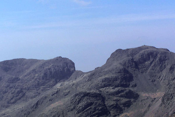 BQL57.jpg Sca Fell, Mickledore and Scafell Pikes from Bow Fell. (taken 20.4.2009) 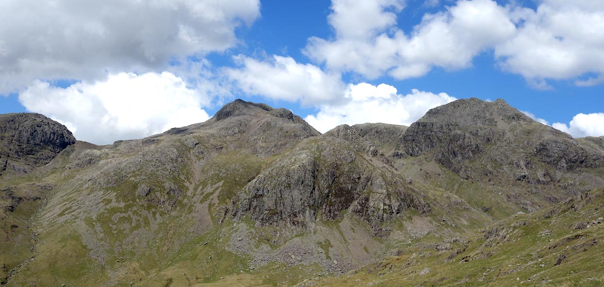 Click to enlarge BYN14.jpg Sca Fell Buttress on the left, then Scafell Pike, Broad Crag, Ill Crag, with Dow Crag in front. (taken 4.6.2013) |
||||||||||||||||||||||||||||||||||||||||||||||||||||||
|
|
||||||||||||||||||||||||||||||||||||||||||||||||||||||
| notes:- |
This is the highest mountain top in England, and is a 'Furth Munro'. |
|||||||||||||||||||||||||||||||||||||||||||||||||||||
|
|
||||||||||||||||||||||||||||||||||||||||||||||||||||||
| observation:- |
BEWARE. The naming of bits of Sca Fell and Scafell Pike is of great interest to both climbers and walkers. It is said that Scafell is the Mecca of the climbing world. Both that world, represented by the Fell and Rock Climbing Club in an admirable series of guides, and the Ordnance Survey in their admirable maps, make a mess of naming and labelling bits of the mountain. Wainwright is more helpful. |
|||||||||||||||||||||||||||||||||||||||||||||||||||||
|
|
||||||||||||||||||||||||||||||||||||||||||||||||||||||
| hearsay:- |
Lehmann J Oppenheimer, The Heart of Lakeland, 1908:- |
|||||||||||||||||||||||||||||||||||||||||||||||||||||
| "... lunch. Pockets soon emptied: bread and butter, potted meat, raisins, chocolate,
crystalised ginger, and brandy - a queer mixture, and no doubt the three tourists
lunching quietly at the hotel would have pitied us as much as we pitied them." |
||||||||||||||||||||||||||||||||||||||||||||||||||||||
|
|
||||||||||||||||||||||||||||||||||||||||||||||||||||||
| hearsay:- |
Up to the 1930s climbers used rope and hobnail boots. In 1933 a climber on Scafell used a piton, a spike and ring. This was declared to be cheating and caused a great fuss in the climbing world - it was a first. Now climbers use pitons, carabiners, and a lot of other gadgets. |
|||||||||||||||||||||||||||||||||||||||||||||||||||||
|
|
||||||||||||||||||||||||||||||||||||||||||||||||||||||
Lakes Guides menu.