 Old Cumbria Gazetteer
 |
 |
|
| Salthouse Junction, Barrow-in-Furness | ||
| Salthouse Junction | ||
| site name:- | Furness Railway | |
| locality:- | Barrow-in-Furness | |
| civil parish:- | Barrow-in-Furness (formerly Lancashire) | |
| county:- | Cumbria | |
| locality type:- | railway junction | |
| coordinates:- | SD21436877 | |
| 1Km square:- | SD2168 | |
| 10Km square:- | SD26 | |
|
|
||
| evidence:- | old map:- OS County Series (Lan 21 12) placename:- Salthouse Junction item:- railway signal |
|
| source data:- | Maps, County Series maps of Great Britain, scales 6 and 25
inches to 1 mile, published by the Ordnance Survey, Southampton,
Hampshire, from about 1863 to 1948.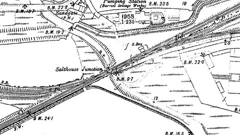 click to enlarge click to enlargeCSRY0133.jpg "Salthouse Junction / S. Box / S.P." to W lines to Barrow Central, Barrow docks; to E liines to Dalton, the Stank Mines, and Piel Island |
|
|
|
||
 Lakes Guides menu.