 |
 |
|
|
|
|
Rowrah |
| civil parish:- |
Arlecdon and Frizington (formerly Cumberland) |
| civil parish:- |
Lamplugh (formerly Cumberland) |
| county:- |
Cumbria |
| locality type:- |
locality |
| locality type:- |
buildings |
| coordinates:- |
NY05711854 (etc) |
| 1Km square:- |
NY0518 |
| 10Km square:- |
NY01 |
|
|
| evidence:- |
old map:- Donald 1774 (Cmd)
placename:- Rowrah
|
| source data:- |
Map, hand coloured engraving, 3x2 sheets, The County of Cumberland, scale about 1
inch to 1 mile, by Thomas Donald, engraved and published by Joseph Hodskinson, 29
Arundel Street, Strand, London, 1774.
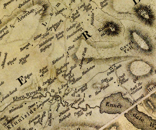
D4NY01NE.jpg
"Rowrah"
block or blocks, labelled in lowercase; a hamlet or just a house
item:- Carlisle Library : Map 2
Image © Carlisle Library |
|
|
| places:- |
 |
NY05961861 Pasture Gate (Arlecdon and Frizington) |
|
|
|
NY05451855 police station, Rowrah (Arlecdon and Frizington) |
|
|
 |
NY05991858 railway bridge, Rowrah (Lamplugh) |
|
|
|
NY05801804 Rowrah Hall Quarry (Arlecdon and Frizington) |
|
|
|
NY05521836 Rowrah Hall (Lamplugh) L |
|
|
|
NY05811839 Rowrah Head Quarry (Arlecdon and Frizington) |
|
|
|
NY05701852 Rowrah Head (Arlecdon and Frizington) |
|
|
|
NY0518 Rowrah Junction (Arlecdon and Frizington) |
|
|
 |
NY05961857 Rowrah Station (Lamplugh) |
|
