 Old Cumbria Gazetteer
 |
 |
|
|
| included in:- |
 road, Windermere to Coniston road, Windermere to Coniston |
||
| road, Coniston to Hawkshead | |||
| Coniston to Hawkshead | |||
| Hawkshead to Coniston | |||
| civil parish:- | Coniston (formerly Lancashire) | ||
| civil parish:- | Hawkshead (formerly Lancashire) | ||
| county:- | Cumbria | ||
| locality type:- | road route | ||
| 10Km square:- | SD39 | ||
|
|
|||
| evidence:- | descriptive text:- West 1778 (11th edn 1821) |
||
| source data:- | Guide book, A Guide to the Lakes, by Thomas West, published by
William Pennington, Kendal, Cumbria once Westmorland, and in
London, 1778 to 1821. goto source Page 54:- "..." "At Water-head, the road to the east leads to Ambleside, eight miles; to Hawkshead, three. Ascend a steep hill surronded (sic) with" goto sourcePage 55:- "wood, and have a back view of the lake. ... turn your face to the east, and you have a view of some part of Windermere-water. The road soon divides; the left leads to Ambleside, the right to Hawkshead, which stands under a mountain, at the upper end of a narrow valley. The church is seated on the front of an eminence that commands the vale, which is floated with" |
||
|
|
|||
| evidence:- | road map:- Cary 1790 (Lan/edn 1792) |
||
| source data:- | Road map, hand coloured engraving, Lancashire, scale about 18
miles to 1 inch, by John Cary, 181 Strand, London, 1790, edn
1792.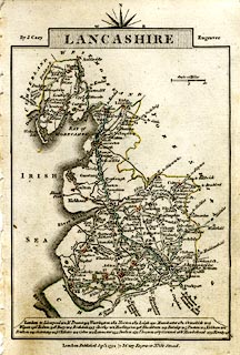 click to enlarge click to enlargeCY46.jpg double line, with road distances from Broughton in Furness item:- JandMN : 418 Image © see bottom of page |
||
|
|
|||
| evidence:- | old map:- Cooke 1802 |
||
| source data:- | Map, Lancashire, scale about 18 miles to 1 inch, by George
Cooke, 1802, bound in Gray's New Book of Roads, 1824, published
by Sherwood, Jones and Co, Paternoster Road, London, 1824.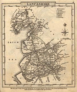 click to enlarge click to enlargeGRA1La.jpg "from Ravenglass" double line, light dark solid; road item:- Hampshire Museums : FA2000.62.6 Image © see bottom of page |
||
|
|
|||
| evidence:- | old map:- Laurie and Whittle 1806 |
||
| source data:- | Road map, Completion of the Roads to the Lakes, scale about 10
miles to 1 inch, by Nathaniel Coltman? 1806, published by Robert
H Laurie, 53 Fleet Street, London, 1834. click to enlarge click to enlargeLw18.jpg light line; 'Other Direct Roads from LONDON' item:- private collection : 18.18 Image © see bottom of page |
||
|
|
|||
| evidence:- | descriptive text:- Ford 1839 (3rd edn 1843) |
||
| source data:- | Guide book, A Description of Scenery in the Lake District, by
Rev William Ford, published by Charles Thurnam, Carlisle, by W
Edwards, 12 Ave Maria Lane, Charles Tilt, Fleet Street, William
Smith, 113 Fleet Street, London, by Currie and Bowman,
Newcastle, by Bancks and Co, Manchester, by Oliver and Boyd,
Edinburgh, and by Sinclair, Dumfries, 1839. goto source Page 15:- "..." "With feelings of mingled delight and regret, the tourist may now leave Coniston and proceed to Hawkshead, over a road wild and dreary, among heath-clad rocks, and past some picturesque cottages, beyond which is seen the town, its white houses, church, and lake, and Furness Fells, making a beautiful pastoral picture." |
||
|
|
|||
| evidence:- | old map:- Ford 1839 map |
||
| source data:- | Map, uncoloured engraving, Map of the Lake District of
Cumberland, Westmoreland and Lancashire, scale about 3.5 miles
to 1 inch, published by Charles Thurnam, Carlisle, and by R
Groombridge, 5 Paternoster Row, London, 3rd edn 1843.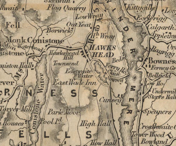 FD02SD39.jpg item:- JandMN : 100.1 Image © see bottom of page |
||
|
|
|||
| places:- | Coniston Hawkshead |
||
|
|
|||
Lakes Guides menu.