 Old Cumbria Gazetteer
 |
 |
|
| Riddings Station, Kirkandrews | ||
| Riddings Junction Station | ||
| site name:- | Border Union Railway | |
| locality:- | Riddings | |
| civil parish:- | Kirkandrews (formerly Cumberland) | |
| county:- | Cumbria | |
| locality type:- | railway station | |
| coordinates:- | NY40807517 | |
| 1Km square:- | NY4075 | |
| 10Km square:- | NY47 | |
| SummaryText:- | Opened 1861; closed 1964. | |
|
|
||
| evidence:- | old map:- OS County Series (Cmd 6 4) placename:- Riddings Station item:- railway signal |
|
| source data:- | Maps, County Series maps of Great Britain, scales 6 and 25
inches to 1 mile, published by the Ordnance Survey, Southampton,
Hampshire, from about 1863 to 1948.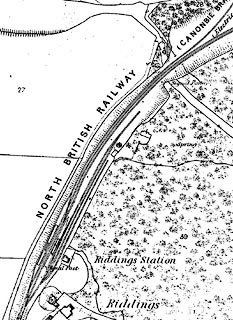 click to enlarge click to enlargeCSRY0036.jpg "Riddings Station / Signal Ppost / NORTH BRITISH RAILWAY" |
|
|
|
||
 Lakes Guides menu.